
Open Data: Roads in India
Posted by naveenpf on 18 September 2018 in English. Last updated on 6 October 2018.India has a road network of over 56,03,293 kilometres(56 lakhs kilometres) as on 31 March 2016, the second largest road network in the world. Openstreetmap has about 15 lakhs of road length mapped in India.
What percentage of the population can reach the nearest hospital in 20 minutes?
What percentage of the population can be rescued by fire and rescue department in case of emergency in 30 minutes ?
We should place our hospitals and fire and rescue stations with the support of spatial data analysis.
For that, we need data, Open Data !!!
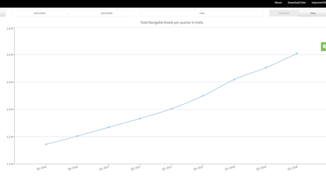
Data from https://metrics.improveosm.org/
- Q3 2016 - 11,71,820 Kms
- Q3 2017 - 13,02,207 Kms
- Q3 2018 - 15,05,239 Kms
Last one year OSM has mapped about 2,03,032 Kms (from Q3 2017 to Q3 2018). Previous one year OSM has mapped about 1,30,387 Kms (from Q3 2016 to Q3 2017).
Myself coming from WikiProject Indian roads in english Wikipedia, maps national highways in India. While national highways constitute 1.8% of Indian roads, they carry 40% of the traffic. I am involved in mapping state highways, major district road and other roads in Kerala too.
National Highway
India:National_Highways_(statewise)
Every month egazette notifications are monitored. For every new NH announced it will be mapped in OSM and an article will be written english wikipedia. A wikidata QID is generated for each National Highway, that links Wikipedia article and mapped National highway in OSM.
Results maps
- National Highways in India by highway number(See the Map)
- National Highway 48 Spur Map
- And Central Govt website for BharatMala project uses our OSM data. (without attribution)
Current Status
- Total no of NH :- 590 (around)
- No of NH mapped in OSM :- 560 - Our Working page (If anyone interested join to help)
- No of NH having article in English Wikipedia:- 437 Our Working page (If anyone interested join to help)
You also can contribute to other road networks in India here.
Some of the road network is also completely mapped fully.
- OSM page:- State Highway (Kerala)
- Wikipedia page :- State highways in Kerala
Roads are mapped manually at the rate of 2 lakhs kilometer per year. OSM India would take 20 years to completely map full road network in India(if it is done manually).
Two things we should try:-
- Govt should release road data in KML format through National Data Sharing and Accessibility Policy in Government Open Data License .
- Road data import using machine learning.(Kerala Road import)
About 1.5 lakh people die on Indian roads every year. We need better road data to plan, monitor, and manage infrastructure more effectively.
In India a death occurs every 3.5 minutes due to road accidents
Discussion