OpenStreetMap 로고 OpenStreetMap

pantierra의 일기

최근 일기 항목

mod_tile, consisting of libapache2-mod-tile and renderd, to instruct Mapnik to generate raster tile images and deliver them via a web server has reached version 0.6 through a broad and constructive collaboration among Free and Open Source Software contributors. And the installation packages have recently become part of Debian and Ubuntu.

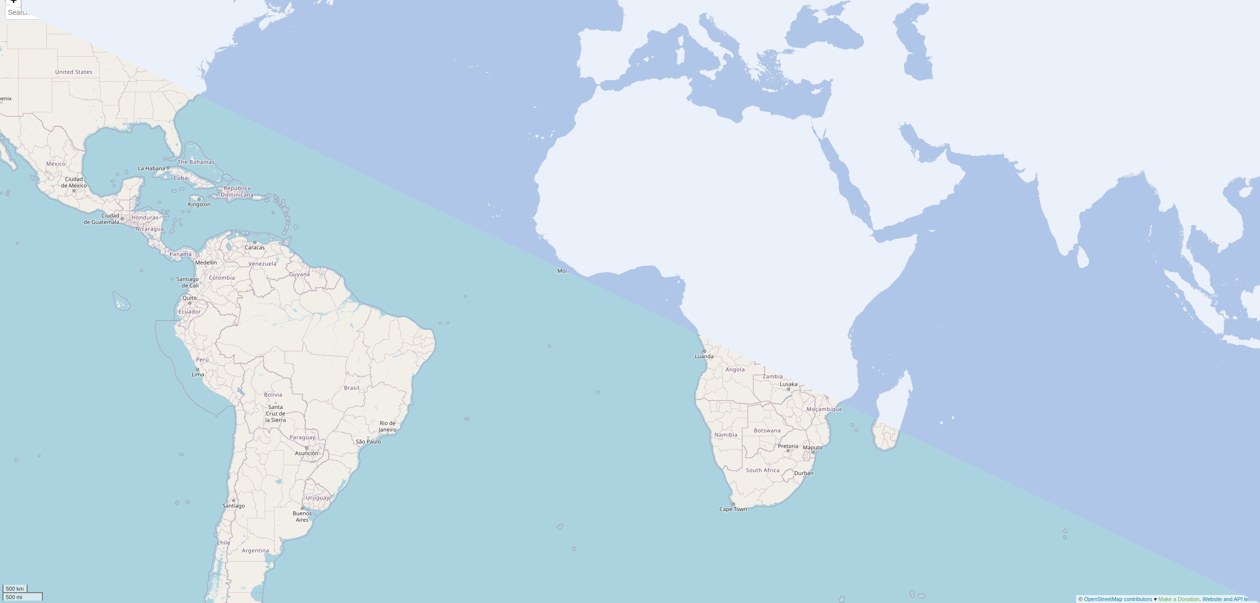
OpenStreetMap.org and many other web map tile servers are using mod_tile with Mapnik to generate and render raster tile images and with Apache2 to make them availabe serving on a webserver. For example for providing a slippy map on the web.

mod_tile has been been actively implemented between 2008 and 2014 by a core group of contributors. The last release was nine years ago when I assumed responsibility for maintenance, at the same there were also many good code suggestions waiting in the pipeline as pull requests on Github.

모든 항목 보기

File management and online collaboration for the OSMF

pantierra님이 English로 2021년 4월 26일에 게시함.

The OpenStreetMap Foundation now offers a file management and collaborative writing platform based on Nextcloud:

https://files.osmfoundation.org

Screenshot of the osmfiles

Up until now, working groups, committees, and the board have often relied on Google services for Foundation work. Based on the recommendations of the FOSS Policy Special Committee in a recent report, and at the initiative of the Local Chapters and Communites Working Group (LCCWG), the Board recently decided to deploy a Nextcloud Free and Open Source Software (FOSS) solution as a privacy-friendly alternative.

The functionality of this software allows you to do:

  • collaborative editing of rich text documents and spreadsheets (similar to Google Docs and Sheets)
  • collaborative editing of simple text documents (similar to Etherpad and HackMD)
  • management of files (similar to Google Docs)
  • calendar sharing (similar to Google Calendar)

모든 항목 보기

The use of Free and Open Source Software in the OpenStreetMap Foundation

pantierra님이 English로 2021년 1월 29일에 게시함. 최근 2021년 1월 31일에 업데이트됨.

The Free and Open Source Software (FOSS) Policy Special Committee of the OpenStreetMap Foundation has been asked by the Board of Directors to assess the degree to which Free and/or Open Source Software or Services are being used within the OpenStreetMap Foundation (OSMF), the board itself, the different working groups, and committees. This analysis focuses on collaborative services to be used over the Internet. The FOSS Policy Special Committee was explicitly excluding the software used by the community at large, local chapters, or systems running on personal computers.

Indicators

The committee has defined two indicators that cover the most important aspects of freedom and openness of software. These are:

1. Programs or Services released under a Free and/or Open Source Software license: Are the programs or services used released under licenses that have been officially approved by either the Free Software Foundation or the Open Source Initiative. Only these licenses are following the standards to be considered free and/or open.

2. Control over data stored at hosted services: The key aspect of hosted services is the ability of the OSMF and the community to fully control the data hosted and to prevent this data from being used for other purposes by a third party. Some of such services are based on open-source software and can be self-hosted by the OSMF, then offering full control and ownership of the data. Non-open services usually do not offer this ability and the full control of the data is at least questionable if not completely impossible.

Inventory

모든 항목 보기

Candidate statement for the HOT board elections 2020

pantierra님이 English로 2020년 7월 18일에 게시함. 최근 2021년 7월 28일에 업데이트됨.

The Humanitarian OpenStreetMap Team (HOT) is opening board elections, and I am delighted to be invited by Miriam Gonzales a.k.a. Mapanauta, Nathalie Sidibe (both current board members) and Enock Seth Nyamador to run for it.

I am a long-time member of HOT, which I joined in 2013 when I was conducting mapping projects during my residency in Nicaragua. Since then I have supported HOT in many ways, from managing the website in the early days to working later as a project manager on the initial machine learning initiatives and leading the technical team to implement version 4 of Tasking Manager. Today I work as a Geospatial Data Systems Architect at the German Research Centre for Geosciences.

HOT Tech meeting Jakarta

I know HOT well and from all sides: as community and project partner with OSM Nicaragua, as active volunteer, as supporting member and as key person in the technical staff. And I am confident that I have the deeper insights to contribute to HOT in an inclusive and constructive way.

모든 항목 보기

Team up in the new Tasking Manager

pantierra님이 English로 2020년 5월 7일에 게시함. 최근 2021년 7월 28일에 업데이트됨.

The Humanitarian OpenStreetMap Team (HOT) has launched the latest software version 4 of Tasking Manager. It comes with a number of enhancements that will improve users’ experience of collaborative mapping in OpenStreetMap. You can check it out now on the HOT Tasking Manager or watch this video to see it in action and what has changed.

Tasking Manager has evolved: technically and visually. Guided by our community of users, who participated in our user experience discovery, and the HOT tech team listened. We have redesigned and enhanced our user interface using state of the art programming libraries.

What is Tasking Manager?

The Tasking Manager is the most popular application to coordinate mapping in OpenStreetMap. It enables anyone, anywhere in the world to team up with others and contribute to the map. The Software is being built by the Humanitarian OpenStreetMap Team (HOT) together with a vibrant Free Software community.

A new approach, a new experience:

모든 항목 보기

Mobile applications for Nicaragua's public transport

pantierra님이 English로 2018년 8월 2일에 게시함. 최근 2021년 7월 28일에 업데이트됨.

How the OpenStreetMap data was made available to people’s smartphones

After the Nicaraguan OpenStreetMap community crowd-sourced with over 250 interested citizens the data of their capital’s public transportation system in OpenStreetMap, a schematic paper map was created from this data.

In a next step the community wanted to offer state-of-the-art routing applications to the visitors and inhabitants of Managua. For this, the data from OpenStreetMap was combined with also crowd-sourced schedule information by the Sofware tool osm2gtfs. The result is the common format for public transport data - GTFS -, which was then possible to include into existing applications, where the data can be used now:


Managua is available in the following mobile aplicaciones

Transportr: Public transport route planner for Android. Because its convenience and its characteristic of being Free Software, it is the best option for users of the collective transport.

모든 항목 보기

위치: Sur Laguna Tiscapa, Sector Sur Laguna Tiscapa, District I, Managua, 11131, Nicaragua

osm2gtfs, extendable for any city

pantierra님이 English로 2018년 8월 1일에 게시함. 최근 2021년 7월 28일에 업데이트됨.

The Nicaraguan OpenStreetMap Community started some years ago a public transport project to create the first proper bus map of a Central American city. Once the data has been collected in a collective crowd-sourcing process directly on OpenStreetMap, a paper map has been created. In a next step this data should be made available in different applications. The most obvious and best path was to rely on the common format GTFS, which can be easily integrated in most public transport routing solutions.

At this point, checking different options to convert OpenStreetMap data into GTFS - unfortunately none was satisfying. Within this desk study I also stumbled over the python script osm2gtfs, by Torsten Grote, the creator of the great Free and Open Source public transport application Transportr. This script was targeted to only work for Florianopolis in Brasil. It grabbed data from OpenStreetMap, parsed online information about schedule from the bus operators’ website and created a GTFS out of it.

모든 항목 보기

위치: Sur Laguna Tiscapa, Sector Sur Laguna Tiscapa, District I, Managua, 11131, Nicaragua

Geotechnology: a tool for innovation

pantierra님이 English로 2018년 7월 31일에 게시함. 최근 2021년 7월 28일에 업데이트됨.

Cover of the printed publication Over the last years several individuals of the Nicaraguan OpenStreetMap community MapaNica.net collaborated fruitfully in various occasions with UNICEF Nicaragua to experiment with participatory geotechnologies and children and adolescents on the Caribbean coast of the country.

This is the publication note by UNICEF Nicaragua (freely translated into English):

모든 항목 보기

위치: Sector Este Avenida Bolivar, District I, Managua, 11123, Nicaragua

Digital Maps that make a change

pantierra님이 English로 2018년 7월 31일에 게시함. 최근 2021년 7월 28일에 업데이트됨.

Article about OpenStreetMap in the print magazine of the Austrian Scientific Exchange Service (OeAD News)

Villagers from Kyrgyzstan mapping with tablet and fieldpapers 
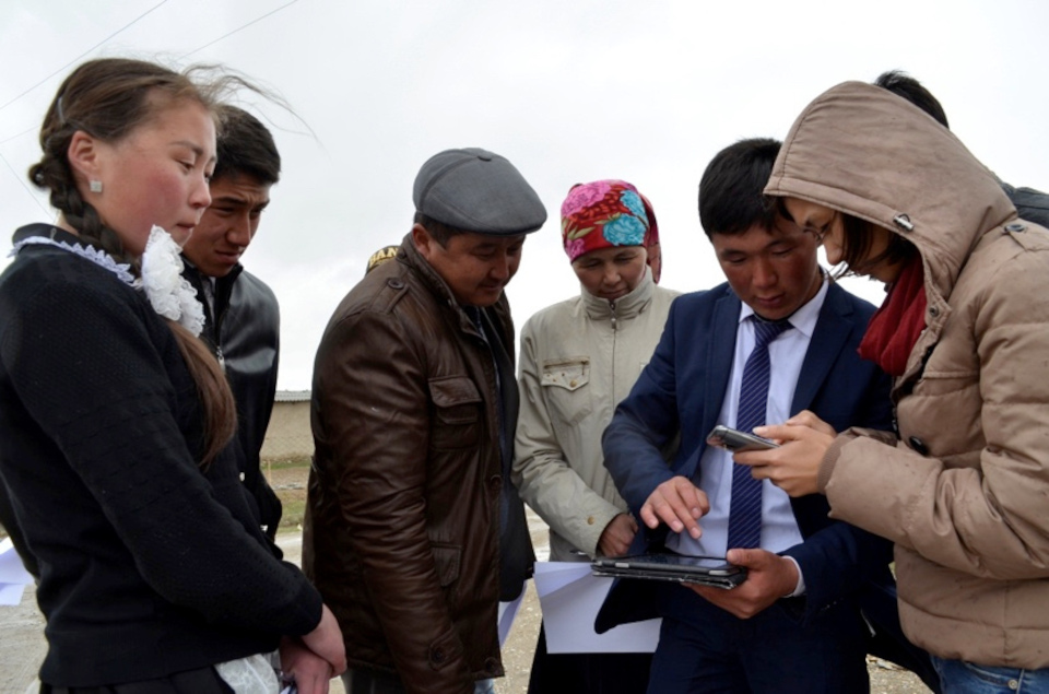
For the two students Taalaikul (15), Ulsana (16) and their teacher Kaiyrgul from the remote village of Jani-Talap, which lies on the edge of the roof of the world - on the Himalayas in the Tien Shan Mountains in Kyrgyzstan - water is the central theme. In the spring, the area is regularly flooded during the snowmelt, but after a few weeks, the wide river bed, which runs past the edge of the village, dries out for the rest of the year. The environment of the village appears dry and barren in summer, snowy in winter. The modesty of the people, but also their poverty can be felt and seen in the village. People make the most of it, having impressive patience and work together to improve the living conditions in this almost forgotten village that is hardly to find on any map.

모든 항목 보기