
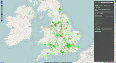
Ordnance Survey have just released their May 2014 version of OS Locator, the comprehensive gazetteer for GB. According to my calculations there are 17,925 new entries and 13,847 removed entries since the last release in November.
I’ve updated my comparison tool Musical Chairs with the new data. New entries tend to show up prominently in the “recent relevant updates” view mode for a few days after an update, so this is a good way of taking a look at what’s changed in your area.
I’d suggest GB mappers take a look at their area, even if not for the purpose of mapping - new releases of Locator often reveal some interesting things about new building projects and developments.
Абмеркаванне
Камэнтар cartinus ад 11 Травень 2014 у 07:37
Hello,
I’ve looked at Nottingham a bit. There is so much green on the map itself (trunk roads, parks and other greenery) that the green circles are hard to see. Your tool might benefit from using (at least as an option) the Mapnik b/w tiles from BBBike.org or any of the other less colourful options listed in the wiki.
Камэнтар robert ад 11 Травень 2014 у 10:56
That’s a good idea - I might add that tile option when I get round to it.