Logo OpenStreetMap OpenStreetMap

Deník uživatele ryebread

Nedávné deníkové záznamy

Attn: Mappers in SE Michigan, US

Zapsal ryebread 28. 12. 2016 v jazyce English.

Last time I tried to do an import, things ended up a bit ugly. I prepared all the data transformations and processes, but I did not receive the permission to use the dataset from Boston GIS, and I was not able to contact anybody from the GIS department. So I gave up. And learned from my mistakes.

After spending some time untangling the lanes on nearby highways in Greater Detroit Area and adding 5 square miles of residential buildings just because why not, I decided to see whether there is any open dataset available to tag these buildings with addresses.

After being told by my city officials that neither they nor the county we are in provide any data, I kept my hopes low.

SEMCOG

Two days ago I discovered SEMCOG, the Southeast Michigan Council of Governments, and today I wrote them for permission to import their data into OpenStreetMap.

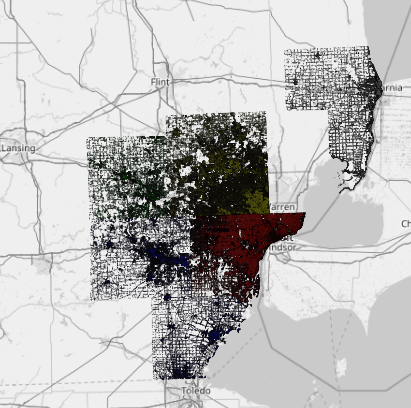
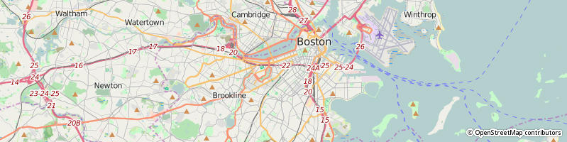
Their coverage is huge:

SEMCOG coverage

Zobrazit celý záznam

Místo: Farmington Hills, Oakland County, Michigan, United States

Validating Basic Routing with CartoType Maps

Zapsal ryebread 3. 8. 2016 v jazyce English. Naposledy aktualizováno 23. 11. 2016

I am using various OSM-based applications as a daily driver for navigation purposes (this month I am fascinated by Magic Earth. They have recently added relief data and traffic-based routing, so go check them out).

I’ve been testing routing primarily with demo OSRM and Valhalla servers, but these services take time to be updated, and I want to make sure my changes don’t break things now.

While browsing the Routing I found CartoType Maps, which is a closed-source desktop application that renders and perform routing locally.

CartoType Maps

A separate makemap application is required to convert from OSM XML to CartoType internal representation.

I found that sometimes the application gives false positives, claiming roads are not connected only because it does not seem to handle turn restrictions properly. Far from ideal, but still better than waiting for the remote servers to catch up.

Zobrazit celý záznam

Really trying to review Scout

Zapsal ryebread 28. 7. 2016 v jazyce English.

As I try to continue writing about various OpenStreetMap-based navigation applications, I’m really struggling to write something about Scout.

Scout

It is a weird application.

It is a combination of a navigation engine (offline download costs money), but it only works in the US, ignores service roads, and does not show buildings. It has a chat built in, but I have 5 chat clients already. It supports sending your location to other people, but these other people must have Scout installed as well, and you can’t just say “here, watch me go somewhere”, you MUST provide your destination (unlike Glympse). You don’t see POIs unless you search for them, and the POI database may not have correct location for the addresses. Since there are no buildings (and no satellite imagery), you can’t see you are directed to a shed instead of Walmart Superstore.

Has anybody here used Scout and thinks it is the best thing since sliced bread?

Místo: Commerce Charter Township, Oakland County, Michigan, 48382, United States

MapQuest Stops Serving Tiles

Zapsal ryebread 17. 7. 2016 v jazyce English.

So, I’ve decided to look at GNOME Maps yesterday and found that this happened: GNOME Maps

http://open.mapquest.com/ shows the following message:

Beginning July 2016, this version of MapQuest, along with Open.MapQuest.com, will no longer be available. We apologize for any inconvenience. If you’re using a map generated from this site on your website, please visit our Developer blog for information on how to transition your map to our updated tiles.

So now all the tiles displayed by MapQuest are hosted on MapBox servers, and every request requires a key to be provided.

actually we don’t do the maps anymore, we use Mapbox. MapQuest is focusing on some mobile and IoT applications, routing and direction engines rather than maps

http://stackoverflow.com/a/38356148/340480

The moment I launched Navmii GPS I was presented with 3 words that looked like this:

https://map.what3words.com/

I started looking for the explanation and found that’s from the service called what3words, that attempts to solve the user-unfriendliness of GPS coordinates by splitting the whole world into 3m x 3m squares and assigning a unique set of 3 words to every location:

Zobrazit celý záznam

Místo: North Farmington, Farmington Hills, Oakland County, Michigan, 48322, United States

As promised before, here’s my review of a navigation application based on OpenStreetMap data, OsmAnd:

OsmAnd: Navigating With OpenStreetMap

I have to say that when I started using OsmAnd+ for surveying location, I saw occasional rendering hickups. It was not as pleasant as the other mapping applications, but it was still doing it’s job.

Things changed dramatically when I tried using it on the roads with 45 mph (76 km/h) speed limit with complex intersections where zoom in/zoom out or turns caused the whole thing to redraw so furiously it was hard to keep track of what was where.

I posted a number of videos to show what I mean and I regret to say that I ended up with a result completely different to what I’ve hoped.

Yes, it is Open Source, and it has a ton of features (and almost awesome OSM Live!), but I just cannot use it for car navigation, sorry.

Místo: Novi, Oakland County, Michigan, United States

TIL about OSRM debug map

Zapsal ryebread 19. 5. 2016 v jazyce English.

A set of turns bypassing a roundabout I reconfigured recently was disliked by OSRM, instead sending the cars via the actual roundabout:

Take the roundabout

Daniel Patterson @ OSRM #2421 directed me towards a debug OSRM map showing that the roundabout links without ‘‘maxspeed’’ tag were categorized with default speeds of ~25 km/h (~16 mph) while the roundabout tagged with 20 mph (32 km/h) provided a faster way.

Zobrazit celý záznam

Místo: West Bloomfield Township, Oakland County, Michigan, United States

In the Beginning There Was a Node

Zapsal ryebread 8. 5. 2016 v jazyce English.

I finally wrote about OpenStreetMap on my personal blog, so here’s the link:

In the Beginning There Was a Node

http://www.keypressure.com/blog/osm-in-the-beginning-there-was-a-node/


On a related note, I am using OpenStreetMap data for all my navigation needs.

I got quite impressed with MapFactor Navigator Android application which seems to have the most up-to-date maps so far and does not have the redraw issues of OsmAnd. Yes, I know, OsmAnd is opensource, but I am not that versed in Android development. Eraser Map Beta seems to be progressing nicely, even though it likes to repeat the turn-by-turn instruction very quickly and several times. I have a list of the applications I tested in the blog post above, and I am preparing detailed reviews for each one.

Zobrazit celý záznam

Místo: Quakertown, Farmington Hills, Oakland County, Michigan, 48335, United States

Boston, MA, US Address import, waiting on license, splitting your buildings

Zapsal ryebread 29. 3. 2016 v jazyce English. Naposledy aktualizováno 30. 3. 2016

The import hit a roadblock. At the moment I am waiting for a license terms clarification from Boston GIS, since the current one was not considered a license by imports/talk-us mailing list members.

The City of Boston recognizes the value and benefit gained by sharing GIS data. Although the City has made reasonable efforts to provide accurate data, the City makes no representations or guarantees about the accuracy, completeness, or currency of the information provided. The City of Boston provides this data as is and with all faults, and makes no warranty of any kind. Each user is responsible for determining the suitability of the data for their intended use or purpose. Neither the City nor its affiliates, employees, or agents shall be liable for any loss or injury caused in whole or in part by use of any data obtained from this website. The GIS data is updated and modified on a regular basis and users are encouraged to report any errors to the City.

Now, while I am waiting to hear back from Boston GIS, I decided to proceed to the second phase - splitting the buildings that house more than one, well, house number.

Zobrazit celý záznam

Místo: City Point, South Boston, Boston, Suffolk County, Massachusetts, 02127, United States

Last time I wrote here I was adding the addr:housenumber tags to some houses automatically using the data from Property Assessment dataset. Since the license was not clear for that data (it is public and provided via Open Government initiative), I decided to pause whatever I was doing and search for an alternative source of data with an explicit license.

City of Boston provides another dataset called Live Street Address Management (SAM) Addresses and it fits our task perfectly.

At this point I decided that this is going to be a full-scale import instead of street-by-street handpicking. I joined the relevant mailing lists and sent the RFC for wiki:Boston Street Address Management (SAM) Import.

Even without any manual work, we are able to assign the unique addr:housenumber to almost 90% of the existing buildings across all the neighborhoods, which is 100% better than no house numbers at all.

The python source driving the transformation is linked from the wiki page as well as .osc files that are periodically generated as I am refining the algorithm. The files must not be uploaded until the import is approved (and .osn files must not be uploaded at all), but you can load them locally and see what the future holds for Boston.

Místo: Bay Village, Back Bay, Boston, Suffolk County, Massachusetts, 02111, United States

Mapping Jamaica Plain, MA

Zapsal ryebread 7. 3. 2016 v jazyce English.

I’ve been occasionally looking at OpenStreetMap project for some “free/opensource” directions, location information, etc. But usually the results for the places I’ve searched were quite poor. It was making me sad and reverting to a mainstream mapping services.

And then I’ve got some free time, and decided that I should not spend the days home, and explore the world that is immediately around me instead. Pairing this with the low quality of Jamaica Plain map (where I currently am) in general, I decided to try fill in as many blank spots as possible.

Source Data

The first thing I found was the ArcGIS-based service from City Of Boston - Boston Tax Parcel Viewer. After spending an hour trying to learn more about map tile services in general I found that there is a MapServer with WMTS support. Since some of the buildings I knew were shaped quite accurately there, I decided to start using is as a common base layer.

Most of the building shapes in Boston in OSM comes from Orthoimagery paired with LIDAR data from some older days as well as people mapping the buildings from Bing imagery. There is newer data available from 2011-2015 Ortho Imagery. I may later switch to these maps even though the rooftop analysis is error-prone, but it is still much better than retracing the buildings from Bing.

The roads for Boston were imported from MassDOT using the data from 2007 and don’t seem to have been update since. Some of the streets had curves that weren’t there in the Basemap or the real world, so I got new ones dated 2013.

Zobrazit celý záznam

Místo: Jamaica Plain, Boston, Suffolk County, Massachusetts, 02130, United States