OpenStreetMap logo OpenStreetMap

seav's Diary

Recent diary entries

OSM 15 Puzzle

Posted by seav on 12 October 2024 in English.

I recently finished this mini-project where I implemented the classic 15 puzzle game but using the standard OpenStreetMap tiles as the sliding pieces!

While there are many implementations of this game online and in app stores (some even let you upload your own image), as far as I know, not one directly uses OSM slippy map tiles for the pieces. I figured this would be a nifty side coding project and it was fun to do!

Currently you can play any of 20 map locations. Enjoy! 🎉

Play the game here: https://seav.github.io/osm-15-puzzle/

Screenshot of a web app showing the classic 15 puzzle sliding game (scrambled) where each tile shows 1/16 of the whole world in Mercator projection 
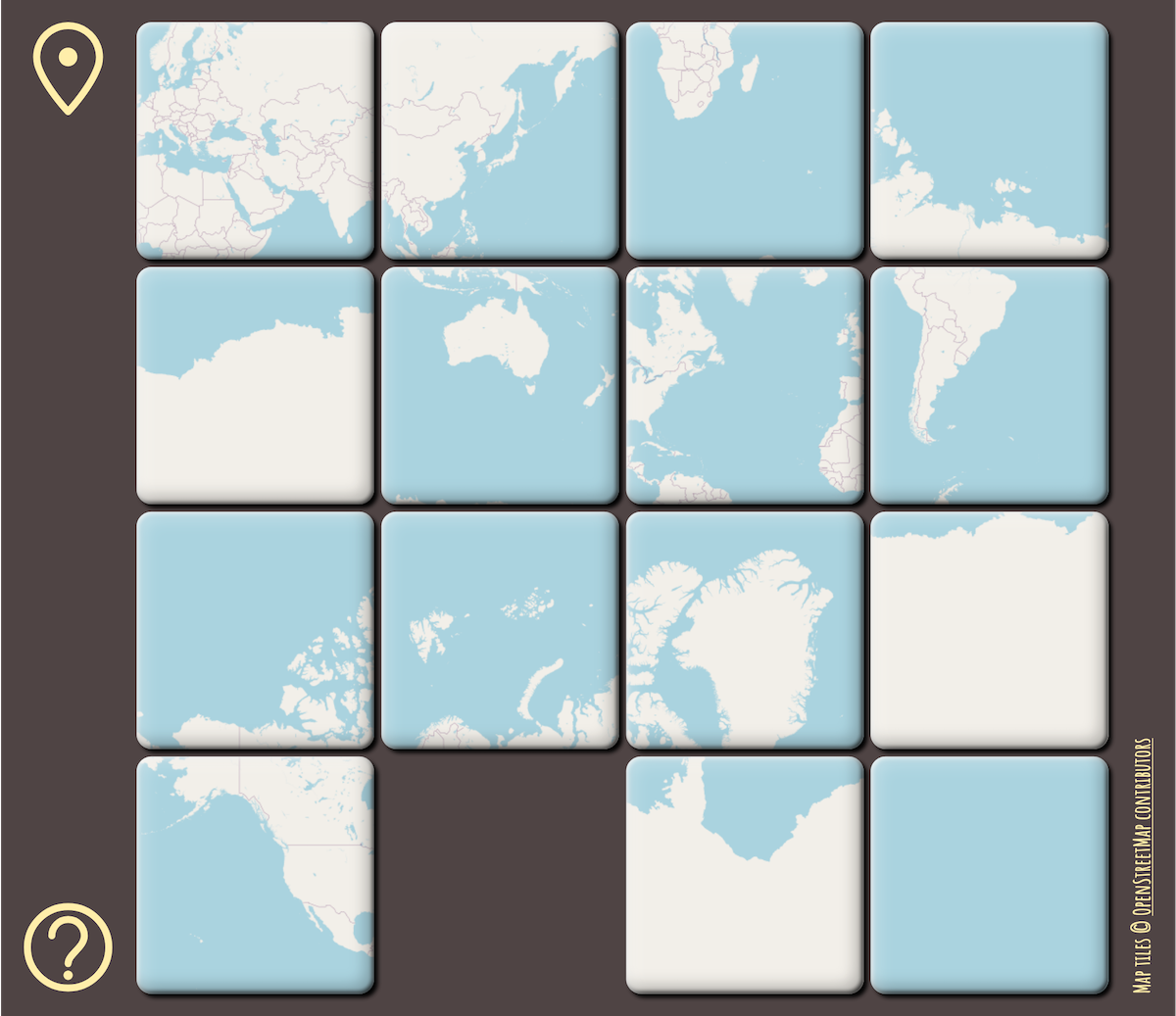
Scrambled puzzle showing the whole world in Mercator projection

See full entry

Cover image of the statement

Last September 1, Amazon Web Services (AWS) released an episode of their documentary series Now Go Build which highlighted the work done by the Humanitarian OpenStreetMap Team in the Philippines, especially in mapping the town of Guagua, Pampanga.

Several members of the OSM-PH community however have observed that there are missing and problematic narratives in the video related to the story it tells of geospatial and humanitarian workers in the country.

Therefore, some of us have prepared and released the following statement: osm.wiki/w/images/a/aa/A_Call_to_Correct_Narratives_about_Geospatial_Work.pdf

Wikidata+OSM at State of the Map 2019 and WikidataCon 2019

Posted by seav on 15 December 2019 in English. Last updated on 16 December 2019.

I’ve been a Wikimedian since 2002 and an OSM mapper since 2007. While there are certainly a lot of differences between the two projects, I believe that there is much more in common between Wikimedia and OSM especially since OSM was directly inspired by Wikipedia (people usually introduce OSM as the “Wikipedia of maps”) and because they both came out of the free knowledge and open data movement (Wikipedia is licensed under Creative Commons and OSM was originally licensed under CC too before switching to ODbL). I therefore support and contribute to efforts for the two communities to understand each other and collaborate with each other. And I am not alone: there are a lot of Wikimedian/OSM contributors like me.

Over the past decade, I’ve given a lot of presentations, talks, trainings, and workshops on how to contribute to and make use of Wikimedia projects (like Wikipedia) and OSM but it was during Wikimania 2014 that I was first able to give a half-hour presentation about both projects and showing how the Wikimedia and OSM communities benefit from and collaborate with each other. (See the session page and my presentation slides.) Since then, I’ve given several talks about essentially the same topic in various Wikimedia and OSM events and you can see an overview of them on the Wikimedia Meta site.

State of the Map 2019 and WikidataCon 2019

See full entry

Typhoon Haiyan, five years after

Posted by seav on 8 November 2018 in English.

Today, November 8, is the fifth anniversary of Typhoon Haiyan, known locally as Typhoon Yolanda, making landfall in the Philippines. This devastating typhoon, which broke the record for being the strongest landfalling tropical cyclone in history, had a lasting impact on the country and its effects are still affecting Filipinos to this day.

For the OSM Philippines community in particular, Typhoon Haiyan radically transformed what it meant to volunteer our time, effort, and resources to map and provide freely accessible geographic data for the country.

Before, the local OSM community was a pretty small group of hobbyist mappers who enjoyed going outside to map and share information about the places we live, work, and play in. But Haiyan showed us that the work we do in mapping the Philippines can sometimes mean the difference between life and death. Past typhoons and storms like Ketsana (Ondoy), Washi (Sendong), Bopha (Pablo), and the 2013 Bohol earthquake had shown the potential of OSM in applications related to humanitarian efforts and disaster resilience, but Haiyan has thrown that into a painfully clear perspective.

See full entry

SotM Asia 2016 group photo SotM Asia 2016 group photo

The second and final day of State of the Map Asia 2016 is almost done and it has been great to hear and learn from OpenStreetMap colleagues from India, Japan, Indonesia, Taiwan, Sri Lanka, Nepal, Bangladesh, Russia, Sweden, the United States, the Philippines, and many other countries.

Location: UP Campus, Diliman, 4th District, Quezon City, Eastern Manila District, Metro Manila, 1101, Philippines

Maps and Ale at OpenStreetMap’s 10th Anniversary Celebration in London

Posted by seav on 31 August 2014 in English. Last updated on 8 November 2018.

The OSM 10th Anniversary blackboard greeting

The London OSM community is quite active having their regular pub meetups, so it was exciting for me to attend their 10th anniversary celebration, which was held at The Artillery Arms. Intentionally held near the Barbican Centre, where Wikimania 2014 was held, the party had a pretty good mix of people from the OpenStreetMap and Wikimedia communities. It was really great meeting people and talking about OSM over pints of ale and beer.

Read more at my blog.

Location: Saint Luke's, Finsbury, London Borough of Islington, London, Greater London, England, EC1V 3RQ, United Kingdom

Presenting about Wikimedia and OpenStreetMap at Wikimania 2014

Posted by seav on 25 August 2014 in English. Last updated on 8 November 2018.

Eugene Villar giving his presentation

Photo Ⓒ Harry Wood, CC-BY-SA 2.0

Over two weeks ago, I had the amazing opportunity to attend Wikimania 2014 in London. Wikimania is the annual conference for the Wikimedia movement, which includes the Wikipedia project. Coincidentally, the conference occurred on the same weekend as the 10th anniversary of OpenStreetMap. As my way of celebrating the anniversary, I gave a presentation about the collaborations between OpenStreetMap and the Wikimedia projects at the conference.

Read more at my blog.

Presentation slides.

Location: Barbican, City of London, Greater London, England, EC2Y 8DT, United Kingdom

Using OpenStreetMap for Disaster Risk Reduction

Posted by seav on 20 January 2014 in English. Last updated on 8 November 2018.

Several people are taking down notes beside a small street-side historical marker bearing the title "Death March, KM 93".

Last November 5 to 7, I and a few other volunteer mappers from the OpenStreetMap Philippines community joined the Environmental Science for Social Change (ESSC) in training the local government of Guagua, Pampanga in contributing to and using OpenStreetMap with an eye for disaster risk reduction.

Read the rest of this piece on my blog.

Location: Santo Niño, San Pablo, Guagua, Pampanga, Central Luzon, 2003, Philippines

Node density in the Philippines

Posted by seav on 25 February 2012 in English.

I created a visualization showing the node density of OSM data in the Philippines taken from the 2012-01-02 Geofabrik extract. Each pixel (in the full-sized image) represents a 0.01°×0.01° degree square or approximately 1 square kilometer. Brighter pixels represent areas with higher node counts.

Node density map

The edges of available satellite imagery at that time is quite visible in some areas like Pangasinan, Cebu, Bukidnon, and Davao del Sur. As expected, brighter areas are places where there is a large amount of editing and with a large population.

Imagery coverage map for OSM Philippines

Posted by seav on 22 February 2012 in English. Last updated on 25 February 2012.

Screenshot of the Imagery Coverage Map

I mentioned in my previous diary entry that I discovered that Bing has added/updated tons of satellite imagery for the Philippines (and apparently also for the rest of the world). This now makes maintaining the catalog of imagery coverage in the Wiki very unwieldy.

So, what I did was to create a simple slippy map to visualize the areas in the Philippines that are covered by Bing and other available imagery.

It's my first time to use CloudMade's Leaflet and I have to say that it's a joy to use. :)

More satellite imagery in Bing!

Posted by seav on 7 February 2012 in English.

At least in my country (Philippines) it seems that Bing Maps has added a whole lot of new/updated satellite imagery sometime within the last two days. The scale of the update is mind-boggling. It’s as if Microsoft went on a satellite image shopping spree! The added imagery seems to have more than tripled the area that is available for tracing. 2012 will certainly be a very busy year for OpenStreetMap in my country, and that’s not just because of the license change. ;-)

Can people in other countries confirm this development?

OpenStreetMap Philippines: 2011 Year in Review

Posted by seav on 23 January 2012 in English. Last updated on 8 November 2018.

A wrote about my personal view of how 2011 went for the OpenStreetMap project in the Philippines.

2011 was a pretty good year for the OpenStreetMap project in the Philippines. Aside from the usual Mapping Parties, the community has organized or participated in several other events, some of them outside the Philippines. 2011 also saw the release of a more improved and usable OSM Philippine Garmin map, and OSM contributors made 2011 the best year in terms of increase of data in the Philippines (thanks to Bing).

Continue reading at my blog.

Wikimania 2011, the annual conference of people in the Wikimedia/Wikipedia movement, is currently happening here in Haifa, Israel. There will be two OpenStreetMap-related items in the conference schedule, both on Friday afternoon, August 5:

1. A workshop introducing OpenStreetMap

2. A Mapping Party right after the workshop on the streets of Haifa

If you happen to be in Haifa, why not drop by and join the mapping party? :-)

Location: Merkaz HaCarmel, Carmel District, Haifa, Haifa Subdistrict, Haifa District, 3463626, Israel

A new phase of OCOSMD

Posted by seav on 1 May 2011 in English.

I wrote over 2 years ago that OSM is far too addicting. And while I still don't think that I'll score high in the OSM purity self-test, my OCOSMD (obsessive-compulsive OSM disorder) has reached a new level.

I've noticed that during the past few weeks, I've been paying extra attention to POIs during my daily commute to and from work and other trips outside the house. I either mentally note them or key them in my cellphone. Consequently, majority of my recent edits have been to "add/update POIs" (an example).

This practice has gotten so distracting that I have to actually force myself to ignore my surroundings so that my mental buffer would not overflow! Sometimes, I pass by POIs too fast for me to remember or note them. Other times, it gets dangerous because it's my turn driving and I have to concentrate on the road. So lately, I've been practicing the art of letting go—letting go of noting down a POIs, that is. :-)

The Manila-Cavite Expressway, which goes by many other names (such as Aguinaldo Boulevard and Coastal Road), is a major tollway in Metro Manila and is designated as part of the Radial Road 1 route (R-1). This road used to go from Zapote, Bacoor to Tambo, Parañaque and functions as a major transit corridor for people who live in western Cavite in going to and from their offices in Metro Manila.

There has been an ongoing project to extend this expressway to Binakayan, Kawit and just last week, the southbound side of the extension was opened to the public. Of course, this was an opportunity for mapping! So yesterday, Good Friday, I went out and took a GPS trace of the extension.

GPS trace containing the R-1 Road Extension

See full entry

Location: Pulvorista, Binakayan, Kawit, Cavite, Calabarzon, 4104, Philippines

Christmas mapping: Metrogate Tagaytay Estates

Posted by seav on 26 December 2010 in English.

I came home earlier today from a house-warming party hosted by my godmother (my mother's cousin) in Metrogate Tagaytay Estates, a gated community in Tagaytay City. The subdivision is quite nice and they apparently have several celebrities owning properties there such as Piolo Pascual, Luz Valdez, Mel Tiangco, Rio Locsin, and Aga Muhlach. In fact, Nova Villa, another celebrity property-owner, was at the party herself!

Anyway, I saw that OpenStreetMap didn't have any data for this gated community save for a now-deleted node, so I couldn't resist going around the subdivision to map everything I can. My siblings accompanied me on my impromptu mapping party (they wanted to look at the architecture of the houses) and we took a GPS track of the road network and got the existing street names (save for one, which I found out later to my chagrin).

And the first thing I did when I went home? I added the data into OSM, of course. :-)

Merry Christmas and a Happy New Year, everyone!

Location: Metrogate Tagaytay Estates Phase 2, Tagaytay, Cavite, Calabarzon, 4120, Philippines

An amusing Mapping Party anecdote

Posted by seav on 15 December 2010 in English.

My slice buddy, Wayne, and I had a funny encounter during last Saturday's Intramuros Mapping Party. So we were walking all over northwestern Ermita in Manila noting down various POIs on a Walking Paper when these two guys called our attention. We ignored them at first because we thought they wanted trouble, but we soon learned that they were merely asking for directions.

"Where is Solidaridad Bookshop?" asked one of the strangers.

Wayne and I laughed because we passed by that bookshop maybe around a half hour before that! If the two guys asked us before then, we would honestly say that we didn't know. But as it was, we had noted down that bookshop and so we consulted our papers and gave the two chaps the directions to the bookshop which was about a block away.

One of the guys noticed what we were carrying and laughed himself saying, "Oh, it's a good thing these guys have a map!"

OpenStreetMap saves the day!

Location: Barangay 667, Ermita, Fifth District, Manila, Capital District, Metro Manila, 1000, Philippines

I thought only congressmen had a penchant for renaming roads. (I have a hunch that half of the laws enacted by Congress are renamings of roads, schools, public buildings, and the like.) But apparently, Ayala Land Inc. has renamed the quite old streets in Ayala Center and has confusingly reused the cardinal directions (like "North") on totally different streets. For context, the renamings appear to be part of Ayala's redevelopment of the Makati Central Business District. (See this news article for context.)

Fortunately for Ayala, most people don't really use the names of these roads to determine addresses and to find locations in Ayala Center, preferring instead to refer to the more well-known buildings like Glorietta. So these recent renamings are not a hassle at all. I very much doubt that people who are not mappers (like me!) would even notice.

So here are the old and new names that I could determine. Some of the old names don't have street signs put up yet so I don't know their new names yet.

Rizal Drive -> West Street
North Drive -> Parkway Drive
Office Drive -> North Street
East Drive -> Courtyard Drive
Hotel Drive -> East Street
Highway Drive -> Station Road
South Drive -> (unknown)
Theater Drive -> (unknown)
Park Square Drive -> (no longer exists)
West Drive -> (unknown)

Of course, I have already edited the data in OSM putting the old name into old_name=* and alt_name=* tags. No other map (Google, RoadGuide.PH, etc.) has these new names yet. :-)

P.S. Zoom to level 17 on the map link below.

Location: San Lorenzo, District I, Makati, Southern Manila District, Metro Manila, Philippines

Mapping part of West Triangle in Quezon City

Posted by seav on 15 November 2010 in English.

Last Sunday, my family attended the baptism of my cousin's kid, but we arrived too early at the church. So what do I do? I map of course! It was a good thing I brought my bag where I keep a notebook and pen. So, while waiting for the relatives to arrive and the ceremony to begin, I walked around the gated community and noted down POIs, street names, and addresses. Good thing the weather was cool making the excursion bearable, though I still worked up a sweat.

Unfortunately, I wasn't able to visit every street due to lack of time (Chronicle and Evening News being the holdouts). Moreover, a roving security guard on a bike approached me and asked if I was surveying. Since I was sure he would say that surveying was prohibited without prior permission from the homeowners association, I said that I was waiting for the baptism to start and was passing the time, which was nominally true. :-) I guess he believed me since he left me and didn't ask to see my notebook. I just continued my survey more discreetly. Hehehe.

Location to map with the correct zoom level: osm.org/go/4zhTBbHCI--

Location: West Triangle Homes, Diliman, 1st District, Quezon City, Eastern Manila District, Metro Manila, Philippines