OpenStreetMap logo OpenStreetMap

skunk's Diary

Recent diary entries

OpenStreetBrowser: New category: Kerbs

Posted by skunk on 29 December 2022 in English.

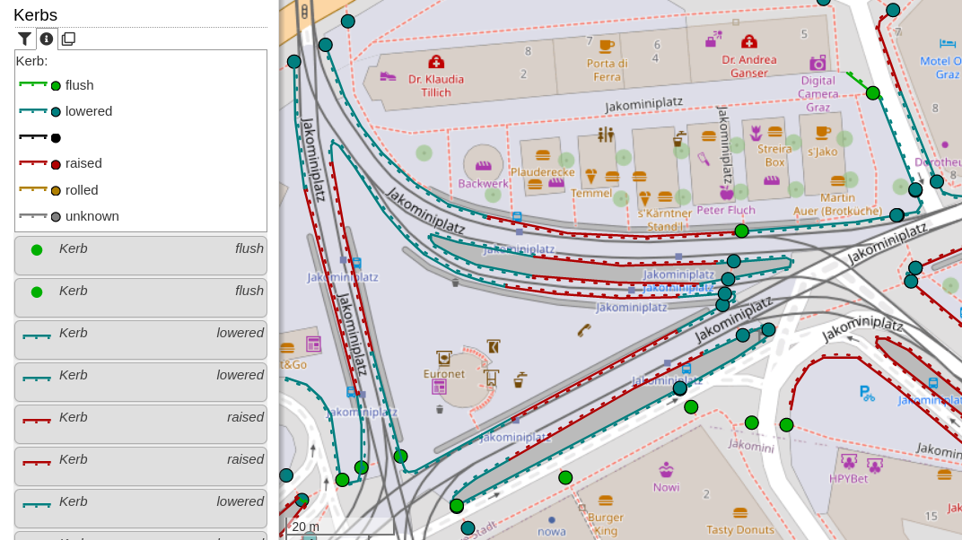
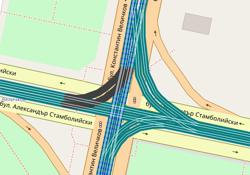
This new category shows kerbs (the edge where a road meets a sidewalk). Read more about this in the OpenStreetMap Wiki. The category uses the colours from the Wiki page. Popups will show additional information: type of kerb (lowered, raised, …), they wheelchair accessibility (if set), if the kerb has tactile paving and the height.

Screenshot of OpenStreetBrowser, showing a map of Jakominiplatz, Graz with the "Kerbs" overlay. In the left sidebar, the map key is visible and a list of map features.

For discussion, please go to the OpenStreetMap Community Forum.

Thanks to a contribution by user danieldegroot2, dates and date ranges are now displayed in Dutch. Other languages which are currently supported are: English, French and German. If you are interested in adding another locale, please check out the module openstreetmap-date-format (HOWTO).

Screenshot of OpenStreetBrowser, with a map showing buildings and their age in colors. A popup on a "Palais Kazianer" is open. It shows the date when the building was completed in Dutch: "tussen de 15e eeuw en de 16e eeuw" (between 15th and 16th century).

The reason for this module is the flexibility of the date system in OpenStreetMap, which allows for inexact dates like “C16” (16th century), “early 2000s” (sometime between 2000 and 2003), and “1848..1855” (between 1848 and 1855).

The new “Footways” category (under Transportation -> Walking) shows sidewalks, footways, steps, platforms and pedestrian zones. Sidewalks mapped on the street way (sidewalk:left, sidewalk:right resp. sidewalk:both) will be shown with an offset - hatching indicates the relation.

Screenshot of OpenStreetBrowser showing the "Footways" category. In the left side the map key for the category is visible, below some of the features in the map view. In the map view a popup on a street with sidewalks is open.

If you have an questions, comments or ideas, please create an issue on Github! Quite some new strings were added to the translation system. Your participation is highly appreciated!

Recently I introduced a few “OpenStreetMap Quality Control” categories:

  • Fix Me - All map features which have a “fixme” (or similar) tag, categorized by suffix (e.g. fixme:name) or content (e.g. “name wrong”). It can also filtered by type of feature (e.g. Shop, Road, …).
  • Culture - Media/Wikidata - In my opinion, each cultural map feature (artwork, memorial, tourist attraction, …) should have an image and/or a wikimedia_commons category (red=missing, light blue=set). Often, there even exists a Wikidata item (dark blue). Many memorials erroneously have the wikidata link to a person (magenta), this should most likely be a “subject:wikidata” (resp. “subject:wikipedia”) tag.
  • Wikipedia - This category was in the “Special” top category before. It shows all map features in the area with a wikipedia or wikidata tag (including prefixes, e.g. “subject:wikipedia” or “name:etymology:wikidata”).

Screenshot of OpenStreetBrowser showing the "Culture - Media/Wikidata" category.

Parcel lockers are a newly approved feature in OpenStreetMap. They are now included in the “Communication” category with a box symbol. I also included the deprecated tags vending=parcel_pickup;parcel_mail_in, vending=parcel_pickup and vending=parcel_mail_in. These will render with a bright red symbol to indicate deprecation, also there’s a warning in the popup.

Screenshot of OpenStreetBrowser, showing the communications category with a popup on a deprecated parcel locker

  • Do you know of more tags which should be indicated as deprecated? I was thinking about adding some QA features for some time, so this is a good opportunity.
  • There’s a new string to translate for this deprecation warning. Find the translation system here.

Recently, I added a new category, which shows all heritage protected items (at least those, which are tagged correctly in OpenStreetMap). Additionally, I created a web-application which helps tagging heritage protected items in Austria (and Berlin, Germany). I blogged about this here.

Screenshot of OpenStreetBrowser, showing the "Heritage Protection" category.

Ich hab letztens schon mein neues Tool vorgestellt, welches dabei hilft, OGD Datensätze mit Wikidata, Wikipedia Listen, Wikimedia Commons und OpenStreetMap abzugleichen.

In einem neuen Screencast hab ich beschrieben, wie man das Tool selber installiert und dann eigene Datensätze hinzufügen kann: https://www.youtube.com/watch?v=4PKUCjS2HL8

Außerdem gibt es einen neuen Datensatz: die öffentlichen Toilettenanlagen in Wien!

OGD Wikimedia OpenStreetMap Checker

Posted by skunk on 10 November 2021 in German (Deutsch).

Screenshot des Tools

Ich hab ein kleines Tool geschrieben, welches dabei hilft OGD Datensätze mit Wikimedia (Wikipedia, Wikimedia Commons, Wikidata) und OpenStreetMap abzugleichen. Es findet sich auf hier: https://www.openstreetmap.at/checker.

Da das Tool nicht ganz selbst-erklärend ist, hab ich ein kleines Erklärungsvideo gemacht: https://www.youtube.com/watch?v=e9Is-3ssA7U

Der Source Code findet sich auf Github. Ich freue mich über Kommentare, Ideen und Code-Beiträge!

Mapping artwork and memorials with Wikimedia integration

Posted by skunk on 3 August 2020 in English. Last updated on 8 October 2021.

Originally, I wrote this post for my blog: http://plepe.at/398

I love mapping for the OpenStreetMap project, it’s a very pleasing thing to do. I especially like to do it as vacation activity, because then I’m exploring new places anyway, but I also like to do it my home town.

Recently I’m concentrating on mapping artwork and memorials. Even in a well-mapped city like Vienna, Austria, there’s still plenty to do. For example, most social housing building complexes (Vienna is famous for it’s social housing) have some kind of artwork, e.g. some murals or statues in the gardens.

Some examples:

See full entry

The category “Construction” under Infrastructure has been split into three sub categories:

  • Construction sites: landuse=construction, highway=construction, building=construction, railway=construction and all items with a tag prefixed with ‘construction:’.
  • Proposals: landuse=proposed, highway=proposed, building=proposed, railway=proposed and all items with a tag prefixed with ‘proposed:’.
  • Developable areas: landuse=greenfield and landuse=brownfield.

Further updates:

Example of the “Developable Areas” category: Image showing a screenshot of OpenStreetBrowser with a greenfield and a brownfield highlighted

The latest feature update brings links to tag listings of an object. There are a variety of tags which will be converted to links: first of all website, url, phone and similar, but also wikipedia, image and wikidata. Finally the “Tag2Link” rules (JOSM also uses this under that name) are imported from Wikidata and OSM Sophox. In some cases there are multiple possible links, which will be presented in a small popup to let you choose an appropriate provider (as you can see in the screenshot for the ‘icao’ tag). OpenStreetBrowser listing tags of an aerodrome

-> https://www.openstreetbrowser.org/

The toolbar in the sidebar now includes a globe symbol. It will show information about the current view and highlight the view center with a crosshair.

When activating GPS location, your location will be highlighted. Also, details will be included in the toolbar panel.

The details of map features show geographic information about the object: coordinates, length and area (when applicable).

In the Options you can configure coordinate formats and unit systems.

Also, in the Options you can select which editor will be used, when clicking the ‘edit’ button in a map feature popup.

For all translators: there are quite a few strings which need translation in the User Interface category.

OpenStreetBrowser showing map view details and map feature details

A current update allows symbols to use the scale of the current map view for parameters (e.g. for width or offset of lines). To demonstrate these features, the “Railway gauge” category now shows the rails with the correct offsets (although the exact configuration for multi-gauge rails is neither mapped nor evaluated) (available from zoom level 18). Code.

Map showing single and dual gauge tramway tracks in Sofia, Bulgaria Map showing single and dual gauge tramway tracks in Sofia, Bulgaria

Details: * The value map.metersPerPixel, which measures the size of the pixel at the viewport center in meters, is now available for twig templates. From this you can calculate the width or the offset of a line in meters. E.g. you could use {{ max(5, 3 / map.metersPerPixel) }} as value for width: 3 meters, or at least 5 pixels. * Related to the first feature, you can now also specify the value of certain style parameters (width, offset, …) with a unit: ‘px’ (for screen pixels) and ‘m’ (world meters).

See the README.md for details.

OpenStreetBrowser: New translation system

Posted by skunk on 7 February 2019 in English.

A few days ago, Ivan Seoane showed me weblate - an open source translation management system. Very nice and very suitable for OpenStreetBrowser. I installed it right away, you can find it here: https://weblate.openstreetbrowser.org. Also, Ivan is working on the translation for Galician, which is already available.

Be aware, that authentication is not connected to any other service (like OpenStreetMap, OpenStreetBrowser Dev, Github, Weblate), so you need a separate account there.

Not all parts of OpenStreetBrowser can be translated there, e.g. date formats have their own separate repository, as you have to actually produce code (it’s just too complex).

This update brings some nice improvements concerning localization: repository-specific language strings, localized start_date and opening_date and a brand-new translation overview page listing all translators.

-> https://www.openstreetbrowser.org/

Buildings age in Graz, Austria Again buildings age in Graz, Austria (haven’t found many places so well mapped). This time with German dates. Note also the image, included via Wikidata.

Read more on the OpenStreetBrowser Blog.