OpenStreetMap logo OpenStreetMap

Diary Entries in English

Recent diary entries

Posted by SomeoneElse on 4 December 2022 in English.

The problem

Historically, the map at map.atownsend.org.uk didn’t change the URL as you moved around, and you had to press a “permalink” button to save the current location. This wasn’t ideal, so I had a look around for alternatives. Helpfully, the Leaflet site has a list of suitable plugins. Of those, leaflet-hash was suggested elsewhere. That seems to be still in use, although it hasn’t been updated for a while. It is spectaculary easy to use, and “does what it does” with no problems.

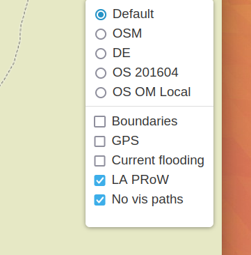
The challenge is that it stores the current location (for example “https://map.atownsend.org.uk/maps/map/map.html#11/54.4900/-3.1098”) but doesn’t store the current layer. That map currently has a choice of 5 base maps (test instances have 6) and 5 overlays:

Layer selector

How to solve this

See full entry

Location: LCPs of Fylingdales and Hawsker-cum-Stainsacre, North Yorkshire, York and North Yorkshire, England, YO22 4QB, United Kingdom

I started to map in OSM at a mapathon in Prague, Czech Republic, in November 2019. Little did I know then that I was lucky to integrate an already existing, well organized Missing Maps Czech & Slovak community. I joined the Missing Maps project with the Médecins Sans Frontières in January 2020 and since then engaged with many more mapping communities - Missing Maps London, the Missing Maps members, HOT community working group, OSM RDC and OSM Uganda, to name a few.

When we discussed the OSM Diary with @ODULANA_OLUWATOYIN and @JaphetMasunzu, I knew I ought to try as well. When I reflected on topics, community building was a top choice among the six ideas I came up with - I will return to the others at the end. Listed in no particular order, these actions will help: 1. Announce next opportunities We always do that at a wrap-up at the end of a mapathon. This means, that you check in with the community members before what events they are planning before your mapathon. Ideally, you already plan the date and format of the next mapathon. A certain regularity of events is helpful to keep people coming back. Typically, we create a slide that we show, whether online or in-person event, that way people can remember better than if they only heard it.

2. Invite the participants of past mapathons

Eventbrite is a helpful tool to set up and keep track of the registrations. You can download a list of registered participants after the event under the Manage event menu, Dashboard section, and set up an email campaign for the next event under the Marketing section. Make sure to send email invitations to those, who registered for your mapathons in the past 6-12 monts. The click-through rate of the invitation email is the highest, compared to the other communication channels, because these people already know what they are in for!

3. Reach existing supporters through e-newsletter

See full entry

Location: Libeň, Prague, obvod Praha 8, Capital City of Prague, Prague, Czechia
Posted by SK53 on 2 December 2022 in English. Last updated on 10 April 2024.

The other day richlv asked on IRC if there was any OSM-based rendering showing the age of buildings. Although I could think of a couple of examples where people have done this, they did not use OSM data (other than the extremely early work.

buildings in central Leiden colour coded by building age

I made use of open data of buildings from Portland Oregon to look at clustering, but the inspiration, and awareness that the data existed, came from a MapBox blog post.

A similar approach was taken by Waag who made use of the BAG open data on buildings for the whole of the The Netherlands.

I wondered if it was possible to use MapCSS styling within OverpassTurbo to create a simple way to achieve the same effect. After a bit of experimentation I was able to do this. I used Dutch localities as test areas as all buildings have been imported from BAG and therefore have start_date tags in a consistent format (“yyyy”). I also looked at other places with some buildings (usually those with a heritage protection) have start_date tags.

See full entry

Location: Binnenstad, Leiden, South Holland, Netherlands, 2312 DH, Netherlands
Posted by JuliusKLahai on 2 December 2022 in English.

A Brief Introduction

My name is Julius Koroma Lahai, a geologist with a keen interest in environmental research and mapping. I’m a graduate of the University of Sierra Leone, Fourah Bay College. I’ve had enough experience with remote sensing and geographic information systems. I started using Open Street Map when I realized that my village, where I spent 14 years, was not visible on maps. My experience with OSM has been amazing, such that I am able to make changes to specific areas that I am very familiar with. In 2020, I was the team leader for the first digital cartographic mapping with Statistics Sierra Leone to delineate enumeration areas ahead of the 2021 Mid-Term Census. I am currently working on the financial inclusion geospatial mapping for the Bank of Sierra Leone under JenMaa Consultants.

Why do I edit and map places with OSM?

See full entry

Location: Gbalahiela Base 1, Hill Station, Freetown, Western Area Urban, Western Area, Sierra Leone
Posted by ODULANA OLUWATOYIN on 2 December 2022 in English.

INTRODUCTION

My name is Odulana Oluwatoyin Abosede, a Geographer with a keen interest in sustainability. A Graduate of the Department of Geography, University of Lagos, It has been an experience-filled OpenStreetMap journey since I joined in 2019 through the Youthmappers initiative at the University of Lagos. Also, Served as the Youthmappers president of YouthmappersUNILAG in 2021.

MAPPING EXPERIENCE

Some of my mapping experience includes; 1. Sustainableenergy4all Mapathon by NESP 2. United Nations Training in partnership with the University Of Lagos 3. Imagery4SocialGood 4. Humanitarian OpenStreetMap Data Quality Internship 2022 (HOTDQI2022). 5. Some Mapping Projects on OpenStreetMap Asides the openstreetmap contributions, i have had experience going to the field to collect data that can be mapped and also created some maps.

MY INTEREST

See full entry

Location: AlakIa, Egbeda, Oyo State, Nigeria
Posted by b-unicycling on 1 December 2022 in English.

Motivated by OpenStreetMap Poland’s openaedmap.org, I went on a targeted survey of AEDs in Kilkenny. I had added some before, and I always do, when I see one, but this time I put some extra effort in, knocked on doors etc.

According to overpass, I’ve edited 141 AEDs, but some are in areas I’ve never been to, so I don’t know how that happened. Unless I used mapillary…Impossible to remember.

Kilkenny is a small Irish town with a lot of tourism. (They want it to be called a “city”, because they got that status in 1609, but the numbers are telling a different story.) I started off using openaedmap.org on my phone, but then I learned about the Quick Actions on OSMAnd, made myself one for AEDs and used it from then on.

Over the course of two days (3-5 hours in total maybe), I went into most

  • hotels (50-50 chance)
  • supermarkets (SuperValu and Dunnes good coverage, Lidl not)
  • shopping centres (100% with 3 surveyed)
  • banks (bad coverage with 2 surveyed, AIB and Permanent TSB)
  • some doctors’ offices,
  • churches,
  • public offices (good coverage)
  • major tourist attractions (coverage depends on size and operator)
  • social facilities (good coverage)

in an about 1km radius etc. Not only was I able to add about 23 unmapped AEDs, but I also raised awareness about the bad coverage after 6pm, because many businesses close then, and none of the AEDs surveyed during these days are outdoors and publicly accessible. Some people also weren’t aware about the closest AED to them or had outdated information.

When I got into longer chats with people, I also got a chance to mention openaedmap.org, and stickers or cards would have come in handy, but they might find it anyway.

See full entry

Location: Gardens, Kilkenny, The Municipal District of Kilkenny City, County Kilkenny, Leinster, Ireland
Posted by Bengeber143 on 1 December 2022 in English.

I wanna to thank you for the organizer in Pista ng Mapa × State of the Map Asia 2022 that they choose me in Free Travel Granted. I didn’t expect to be choosen in Free Travel Granted even I don’t have laptop they still to choose me.

In 5 days of conference of Pista ng Mapa × State of the Map Asia 2022 I amaze that they are so many open source and open data of map. Some maps that animate, also others map can traces a weather path, and also can traces where did you stop and where did you go. Also the Dronebirds Are Go that presented by Sir Taichi Furuhasi that can give some supply for some disaster event that no one can go because of disaster, so the drone only can give them a food resources.

I also have fun in amazing run with Sir Taichi Furuhashi, Justine May Gamayon, Shaira Jane Pagaran and Vince Alain Salcedo, we won in this activity. I hope in next Pista ng Mapa × State of the Map Asia 2022 we can see each other.

OSMDIARY

#PnM×SotMA2022

Last week, we celebrated the 4th Pista ng Mapa (Festival of Maps) as well as State of the Map Asia 2022. I finally get to physically meet and interact with open data, open source, open mapping and Openstreetmap advocates and contributors after the pandemic. I will write more about my experience in another entry.

In this diary, I would like to honor a person whom I have never physically met but have made a huge difference in my career - one of the pioneers of GIS in the Philippines, the founder of PhilGIS.org and an open geodata advocate who showed compassion to a young beginner mapper / aspiring GIS Specialist (me), Sir Alejandro “Al” Tongco.

Thank you Pista ng Mapa x SotM Asia organizers for remembering his work through the Tatak OSM PH Award :)

Sir Al Tongco's Tatak OSM PH Award, photo by Ms. Janjan Orano Sir Al Tongco’s Tatak OSM PH Award, photo by Ms. Janjan Orano

PhilGIS.org : The first open geoadata source in the Philippines (that I know of)

See full entry

Posted by deepblue66 on 1 December 2022 in English. Last updated on 2 December 2022.

In some parts of the map the density of objects is very high. Therefore I like to filter unecessary parts of it. If you need to understand e.g. routing issues, the other way round may be helpful: show only what you need.

Declutter

  • landuse=* or natural=tree
  • boundary=* or disused=*
  • railway=*
  • building=* or “building:part”=yes or man_made=tower or role:perimeter

Attention

Routing

access=* or psv=* or taxi=* or bus=* or minibus=* or disabled=* or emergency=*

POI

shop=* or office=* or craft=* or healthcare=* or leisure=fitness_centre or amenity=cafe or amenity=restaurant or amenity=pub

Posted by trixabella on 30 November 2022 in English.

Project: Uganda 2022 Ebola Outbreak - Kitumbi Subcounty Kassanda District Project

Today I got the email notification that the last of my tasks had been verified, and at 9:00am received confirmation that the project has been completed.

Total Hours Contributed: 4 hours 10 min

Checking the task manager there are 2 more projects relating to the Ugandan Ebola Outbreak. As I have gotten used to the style of mapping I have decided to start on another of their district mapping projects:

UGANDA 2022 EBOLA OUTBREAK - BANDA SUBCOUNTY MITYANA DISTRICT

I recently wrote about using a Tag-Fix MapRoulette Challenge to update OSM data in an efficient way, no editor required. Tag-Fix is one of two newer Challenge types MapRoulette has available. The other one is called Cooperative. They are called Cooperative because it’s a cooperation between you and the Challenge owner. The Challenge Owner provides the OSM changes, you validate them, tweak them as needed, and commit them to OSM. Cooperative challenges are ideal for when you may be thinking about an import, but you would like to have each feature manually verified by a mapper.

Today, we will look at how to set up a Cooperative Challenge using Microsoft Building Footprints open data. (In a future post we’ll look at how to work with the Challenge as a mapper.) This is not really a beginner’s tutorial; we will be working with PostGIS, QGIS and the command line tools imposm and ogr2ogr. If you have those tools installed and are just a little familiar with them, you should be able to follow along fine!

This is what the final result will look like:

See full entry

Location: 9th & 9th, Salt Lake City, Salt Lake County, Utah, 84102, United States
Posted by joyceeemaeee on 29 November 2022 in English. Last updated on 30 November 2022.

The SotMAxPnM2022 International Conference emphasized the value of employing open source, open data, and open mapping in the current state of technological growth. - November 21–25, 2022, Legazpi City, Albay, Philippines. Events were held by several groups in addition to the conference sessions and workshops. Also hosting their social event were Youthmappers, Mapbeks, and GeoladiesPH. My memories of the Pista ng Mapa Conference and the State of the Map Asia Conference are still fresh, but they will always be remembered.

Let me express my gratitude to the State of the Map Asia x Pista ng Mapa Organizing Team for the opportunity to be one of the local travel grantees. Also, attending the conference does not have enough money, but big thanks to Sir Aimon Pangan and to COLLADEV for adopting our YouthMappers chapter for the whole week (we miss the breakfast, Ka sama ka Sir). We do not have any funds, but I/we are forever grateful for this once-in-a-lifetime opportunity!

To the Bicol University College of Engineering, thank you very much for the kind welcome. We really enjoyed our time at your prestigious university. We appreciate that you keep our surroundings pristine and secure. A special thanks to Christine and the two guys who were with us that day for showing us around their big campus.

Fast-forward to the “State of the Map Asia x Pista ng Mapa” occasion. The work of Mr. John Louie Fabila in producing 3D animated maps to encourage greater interactions captivated me. Sir Aimon Pangan for sharing his work on Data-Driven Development for Policymaking with Kobocollect; I was blown away by how Sir Aimon works with the community in other places. Also, to the UP Tacloban Youthmappers, Kuya Michael Joshua Orais, although I didn’t attend the workshop because it was already full, I was fascinated by your presentation, “Ang Unang Paglipad,” because the first YouthMappers chapter has drone training.

See full entry

Location: Cruzada, Legazpi, Albay, Bicol Region, 4500, Philippines

Introduction

The OSM community is made up of volunteer contributors from different countries around the world, who are dedicated to improving the world map. To contribute to OSM it is required first to have an OSM account and to be trained on how to contribute. These contributions are subject to validation in order to censor errors that may have crept in during the mapping process. Through this data quality internship, we had the opportunity to be trained on how to do the validation process.

Frequently observed errors

During the validation practice, for the tasks that were validated so far, here are the common mistakes made by the contributors that we noticed: - Buildings with non-square corners. However, the instructions for the projects always give clear directions for this! - Not completely mapped spots, especially in rural areas where there are circular buildings; - The use of some inappropriate tags, especially for circular buildings like “building=hut”.

Recommendations

Here are some recommendations we make: - Always remind contributors to a mapping project right at the beginning, especially beginner mappers that before locking a task into a project for mapping, first read the project instructions carefully; - Validate the tasks in time, so that the given remarks help the cartographers to improve; because a remark given after 1 or 2 years in my opinion has lost its meaning. Thanks again HOT for this good opportunity where we are being trained and informed a lot.

Location: Ngere, Butembo, Kimeni, Butembo, North Kivu, Democratic Republic of the Congo
Posted by trixabella on 28 November 2022 in English.

Project: Uganda 2022 Ebola Outbreak - Kitumbi Subcounty Kassanda District Project

Starting today with reviewing my notifications within the HOT Tasking Manager.

The following tasks have now been verified by moderators and are completed for the project:

  1. Task 306 (this was the one I had additional mapping to complete yesterday)

  2. Task 428

  3. Task 150

  4. Task 266

  5. Task 233

The project that I have been working on (Uganda 2022 Ebola Outbreak - Kitumbi Subcounty Kassanda District Project) is now nearing completion with only 3 sub-squares left to map (the remaining tasks are awaiting verification prior to completion)

  1. Task 512 - 35 mins

The last task I helped with Task 511 (25 mins) had a number of areas where I couldn’t distinguish between houses or ground distrubances, so instead I completed as much as I could then submitted the task as uncomplete to allow another mapper to review and contribute.

As the only other remaining tile was locked this is the end of this project for me and I will need to look for a new project to work on next.

Total Time: 1 hour

Getting new users to contribute to collaborative mapping with OpenStreetMap sometimes can be a hard task, and even more difficult when you think about attracting new women users, especially if you are in a country like mine, Brazil.

Why do I speak of new women users? Because if you are in a country like mine, Brazil, most users are men, and this is not the reality in cartography courses, then why women in general aren’t participating, because they do not feel encouraged to participate, is that it?

In this text I will talk a little about my experience for you. Here in the group that I am part of with my college friends, we were having a hard time getting new girls to join the group and trying to understand this reality we met the group Geochicas OSM, a group of Latin America, a collective that came up with the idea of closing the gender gap among those who participate in the collaborative mapping project OpenStreetMap (OSM).

See full entry

Location: Cabula, Salvador, Região Geográfica Imediata de Salvador, Região Metropolitana de Salvador, Região Geográfica Intermediária de Salvador, Bahia, Northeast Region, Brazil