OpenStreetMap logo OpenStreetMap

Diary Entries in English

Recent diary entries

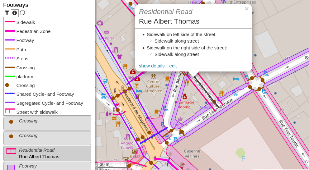
The new “Footways” category (under Transportation -> Walking) shows sidewalks, footways, steps, platforms and pedestrian zones. Sidewalks mapped on the street way (sidewalk:left, sidewalk:right resp. sidewalk:both) will be shown with an offset - hatching indicates the relation.

Screenshot of OpenStreetBrowser showing the "Footways" category. In the left side the map key for the category is visible, below some of the features in the map view. In the map view a popup on a street with sidewalks is open.

If you have an questions, comments or ideas, please create an issue on Github! Quite some new strings were added to the translation system. Your participation is highly appreciated!

As I’m involved in running the OSM Foundation board elections, I thought it would be interesting to share some statistics on the OSMF members who are eligible to vote this year, compared to last year.

Thanks and data sources

Thanks to:

Regions of OSMF members eligible to vote

This year 1518 out of 1937 OSMF members (as of 2022-12-07), from 96 countries, are eligible to vote in the 2022 board election. The regional distribution is shown on the image below and the table is also on the OSM wiki.

Regions of OSM Foundation members eligible to vote in 2021 and 2022 OSMF board elections

Notes:

See full entry

Posted by watmildon on 9 December 2022 in English. Last updated on 28 March 2024.

Update: Check out my comment below about the state of the art being greatly improved!

Northeast US address density

The idea

After finishing my first address import I was looking for a good view of “where else needs addresses”. One trick that always pays dividends for me is to look at distributions of ratios of various quantities. In particular, I presumed there should be a pretty smooth distribution to the ratio of number of addresses vs number of buildings in any given area.

Building it

osmconvert alabama-latest.osm.pbf -o=alabama-nodes.csv --max-objects=50000000 --all-to-nodes --csv="@lat @lon addr:housenumber building"
  • A bit of C# to do the binning (I’m sure QGIS and other tools are great for this but you use what you know)
  • Tableau Public for the viz generation

The results

See full entry

Many of the features we had to deal with in the Sq___ renaming were small streams and creeks. For some reason, Sq___ Creek seemed to be a very popular name. In most cases, the creeks weren’t present on OSM, and as part of the renaming, we decided to add missing features with the new names so that future mappers wouldn’t unknowingly add the features with the old Sq___ names. So, we had to map a lot of small creeks.

One of the challenges with mapping named waterways is identifying the full extent of the waterway. Where is the mouth of the waterway? Where is the source? Of the many branches upstream from the mouth, which branch is the identified course?

If you’re just working with GNIS, the GNIS data has two or sometimes three sets of coordinates for waterway features. The first coordinate is the mouth. If there is a second coordinate, it falls somewhere in the middle of the waterway. The last coordinate is the source.

From there, you can use topo and aerial maps to trace the course of the waterway by hand.

Alternatively, you can download the local data file from the National Hydrography Dataset, find the waterway you want, merge it into an OSM layer, and clean it up before uploading it. Here’s how that works:

See full entry

Posted by Ivy Perez on 8 December 2022 in English. Last updated on 23 June 2024.

The celebrations have been over for more than a week, yet the Pista ng Mapa X State of the Map Asia 2022 spirit still abound!

The first international conference I attended just happened so fast. I still remember the time that I was accepted as one of the local travel grantee of this international conference in Albay, Legazpi. One thing that came into my mind for attending the conference is that I will be seeing the beauty of great Mt. Mayon but I was wrong, It was the experiences and learnings that will be my souvenir once I got home.

I had been part of the Viscan YouthMappers Organization in Visayas State University in Baybay City, Leyte, Philippines. Since I joined the organization months ago, I started contributing in Open Street Map to map places that needed help on disaster response and planning on a certain area. Through this conference, I was able to share my hardwork and perseverance to other people I just met.

See full entry

Location: Gabas, Patag, Baybay, 5th District, Leyte, Eastern Visayas, 6521, Philippines
Posted by mcepl on 8 December 2022 in English. Last updated on 24 December 2022.

I understand that for most members of this community this is offensively primitive, but I have spent an hour ploughing through all APIs, so until https://github.com/mocnik-science/osm-python-tools/issues/70 is fixed perhaps it helps somebody:

# From URL (e.g., "https://www.openstreetmap.org/way/30722274#map=14/49.2925/38.1815")
# to geo-URI of the center of the object: geo:49.2953098,38.1827257

import os.path
import sys
import urllib.parse
from OSMPythonTools.cachingStrategy import CachingStrategy, JSON
from OSMPythonTools.api import Api
from shapely.geometry import shape

CachingStrategy.use(JSON, cacheDir=os.path.expanduser("~/.cache/osm"))

api = Api()

parsed_url = urllib.parse.urlparse(sys.argv[1])
way = api.query(parsed_url.path)
geom = shape(way.geometry())
print(f"geo:{geom.centroid.y:.7f},{geom.centroid.x:.7f}")

Complete program is now hosted at https://sr.ht/~mcepl/osm_where/

Insert Wikidata into POI in OsmAnd

Inserir Wikidata em POI no OsmAnd

Brief tutorial on how to insert Wiki (Wikipedia/Wikidata) into Points of Interest (POI) in OsmAnd application with OpenStreetMap map. By Túllio M. Franca - UMBRAOSM

Breve tutorial de como inserir Wiki (Wikipédia/Wikidata) em Pontos de Interesse (POI) no aplicativo OsmAnd com mapa OpenStreetMap. Por Túllio M. Franca - UMBRAOSM

https://pt.slideshare.net/umbraosm/inserir-wikidata-em-poi-no-osmand-254777845

Tulio França https://www.instagram.com/ondecetaa/

UMBRAOSM - União dos Mapeadores Brasileiros do Openstreetmap www.umbraosm.com.br

8Hours on Air 8Hours on Land

Inaugural State Of The Map Conference Nigeria 2022

The thing that made me attend this meeting was to share my experience from a big project that took place here in our country in Tanzania, which was related to the collection of Mills Information to check the level of food and nutrition. It was a Community-oriented project that involved 1091 community members and 1091 motorcycle riders.

TANZANIA NATIONWIDE MILLS CENSUS REPORT, 2022 Tanzania Nationwide Mills Mapping

Apart from sharing our experience, the other purpose of attending the conference was to get different backgrounds from different countries and see what they were doing and if we could do it in our country.

See full entry

Location: Alakahia, Obio/Akpor, Rivers State, 500004, Nigeria

Community Mapping - OSM

Mapeamento de Comunidades - OSM

Mapeamento de Comunidades - OSM Presentation of the Community Mapping Project in Brazil on OpenSreetMap integrated with other free platforms such as OpenAerialMap, Mapillary and Wiki as well as the use of StreetComplete. By Túllio M. Franca - UMBRAOSM

Apresentação do Projeto de mapeamento de comunidades no Brasil no OpenSreetMap integrado a outras plataformas livres como OpenAerialMap, Mapillary e Wiki bem como uso do StreetComplete. Por Túllio M. Franca - UMBRAOSM

https://pt.slideshare.net/umbraosm/mapeamento-de-comunidades-osm

Tulio França https://www.instagram.com/ondecetaa/

UMBRAOSM - União dos Mapeadores Brasileiros do Openstreetmap www.umbraosm.com.br

Just discovered this user 4 days ago from this note. This user is not a vandal or anything, a user has no edits yet instead of deciding that it already existed in OpenStreetMap, but it isn’t lived in OpenStreetMap. It existed on other maps likely than Google Maps.

Location: Makiling, Calamba, Laguna, Calabarzon, 4027, Philippines
Posted by Nahomi Garcia on 6 December 2022 in English.

Whether you’ve just completed school or you graduated decades ago, there are likely many things you don’t know about the extraordinary planet on which we live.

For instance: Were you aware that the Pacific Ocean is shrinking every year? Or that the world includes a sea without coasts? Or that Alaska isn’t just the westernmost state in the U.S., but the easternmost as well?

The third rock from the sun is much more complex than you may think — as evidenced by these alternative facts about geography.

Location: Lystvet, Skiptvet, Østfold, 1816, Norway

the plethora of the edits that am more focused on the time that am writing this exact note are agrotic Rural Roads between the Ayia Napa - Sotira - Paralimni borders, inside the Forest of Agios Antonios and several places near. Η πληθώρα των εξεργασιών που επικεντρώνομε αυτή την στιγμή είναι οι αγροτικοί δρόμοι στα δημοτικά σύνορα της Αγίας Νάπα - Σωτήρας - Παραλιμνίου εντός του Δάσους του Αγίου Αντώνιου και στις τριγύρω περιοχες

  • Exact (“micro”) mapping
Location: Ayia Napa, Agia Napa Municipality, Famagusta District, Cyprus, 5330, Cyprus
Posted by Pragya Pant on 5 December 2022 in English.

Introduction

My name is Pragya Pant. I am a geomatics engineer from Nepal.

My OSM Journey

I started mapping in OSM from year 2020. This journey started with mapping just for fun and utilization of my free time. After mapping for few months I started to realize the use and importance of the data I created and how it was impacting the lives of people. Now that I know the value of my contribution I map for a reason.

Interest for mapping

Being a geomatics engineer I have always been fond of mapping. I have been mapping using GIS software and have a knowledge of remote sensing and photogrammetry. I love mapping through field visits interacting to communities so that I can impact them positively. Getting OSM as an open platform I feel lucky to contribute where I use my skills of engineering to impact the communities of any part of the world through remote mapping.

Experience

From the point I realized the importance of OSM data I started mapping for projects that are running in Nepal. My experience in various OSM projects are as follows:

  1. OSM Mapping and Data Validation of Kailali/Kanchanpur/Doti/Dadeldhura/Rasuwa Districts
  2. 15 days 15 mapping campaign for mapping unmapped trials and settlements in the remote Dolpa district of Nepal organized by Youth Mappers
  3. Digitized buildings of Kathmandu Metropolitan City remotely using Open Street Map (OSM)
  4. Remotely mapped building footprints of different cities of Afghanistan
  5. Field participant of HOT Microgrant project- “Mapping Chepang community of Nepal”
  6. Participant in women leadership initiative “She Leads and She Inspires: Women in Leadership Program”- Asia-Pacific Region
  7. HOT Data Quality Intern for 2022

See full entry

Posted by KingVik on 5 December 2022 in English. Last updated on 4 July 2023.

My 5 years celebration with OpenStreetMap

Down My (OpenStreetMap) Memory lane…

I was just a Geo-informatics and Surveying Polytechnic student at Akanu Ibiam Federal Polytechnic Unwana, Ebonyi State. We used to have practical sessions using Surveying instruments but with time I realized that we are doing the same thing over and over without any data being stored. We would just acquire, use and trash! I then decided to form a team of 4 with my fellow students who I convinced of my vision – we would collect the data, save it and be updating it later to make data available to all and easy to access. We set objectives to achieving our aim and being close with my Head of Department and my lecturers give us access to instruments at any time. We decided to pick every existing feature within the school - it was a difficult experience for months but my passion for data kept me going. At the end of the struggle, we had the data and I then created a unique map for my school which is currently serving as the base map for the school even up to this day. The result got applauded by the department as I made it easy for anyone who may need data for a particular section of the school they can get it easily, saving time and eliminating use and trash. Since that day, I started keeping any data I collected and saving it for reuse. Initially I wanted to pursue Computer Science and Electronic Engineering because of my love for computers and I wanted to change the world as my strength could carry me but alas, I found myself in Geo-informatics and Surveying and completely fell in love with it. More like it was meant for me.

How I met OpenStreetMap

See full entry

It was a big surprise when I received a mail that mentioned I would be presenting at State of The Map Asia 2022, my first-ever International Conference. The moment became more exciting when Open Mapping Hub - Asia Pacific sponsored us to visit Legazpi, Philippines, and present our work in person. Ever since I started contributing to OpenStreetMap around 5 years ago, this was the first time, I had been a part of such a great event. I thought all the hard work and perseverance had finally paid off.

Due to General Election in Nepal, we missed the first two days of Pista NG Mapa but were able to attend all the sessions of SOTM Asia, 2022. Since it was my first international flight, it was a whole new experience and excitement when I reached Legazpi City on 22th Nov. Mount Mayon covered under the cloud was there to welcome us to this beautiful land where we were about to meet OSM enthusiasts around Asia and spend the most exciting five days of my life.

Mount Mayon

See full entry

Location: Tilottama-08, Deepnagar, Tilottama, Rupandehi, Lumbini Province, Nepal