OpenStreetMap logo OpenStreetMap

Diary Entries in English

Recent diary entries

Posted by courtiney on 1 May 2023 in English. Last updated on 26 May 2023.

Hi, everyone,

Between the end of April and mid-May, my former TomTom colleagues * and I posted a communications survey with the goal of gathering some information about how OSM users experience OSM community communications. Now that the survey is complete, I want to give it context as part of our presentation at State of the Map US in Richmond, Virginia.

At SotM US, we will be presenting on How to Use Data for Effective Community Communication. (The project is supported by TomTom and informed by work that two of us have done for the CWG, but it’s not formally a TomTom or OSMF project.) Our primary source of data for this presentation is derived from a tool that scrapes publicly available, anonymized, channel data from OSM listservs and forums. To augment this data, we created a communications survey. We knew that we would not be able to get a broadly representative cross-section of the OSM user demographic with our limited time and resources, but we did believe we would get some additional details that could help inform our approach.

The survey had a mix of free answer and multiple choice questions about demographics, local community involvement, and experiences using the various forums, lists and other channels. We created 12 versions of the same survey to post in 12 different channel types so that we could get a sense of the user demographics per channel: community forum, mailing list, Telegram, Twitter, Discord, Slack, Mastodon, Reddit, IRC/Matrix, weekly OSM, Facebook, LinkedIn. We received 464 responses, with more responses from Europe and North America than from Latin America, Asia and Africa. We will present a few of the observable trends at our presentation, with the caveat that they are more impressionistic than representative.
See full entry

Location: White River Junction, Hartford, Windsor County, Vermont, 03784, United States
Posted by Peter Elderson on 30 April 2023 in English. Last updated on 13 May 2023.

Turbo roundabouts are relatively new. They first appeared in Nederland, but are now starting to appear in many countries, including the US. I have tried my hand at mapping one, guided by a few front runners, then did a second one on my own. This diary entry details what I learned. As I go on, I will add things learned to this diary entry!

See [roundabout=turbo] (osm.wiki/Tag:roundabout%3Dturbo)

Variations: It’s hard to find two turbo roundabouts that are exactly the same. This is what I learned: Take care to start with an easy one, and never blindly apply the prescriptions. You have to know what it’s for. That’s why this diary entry contains a lot of explanation: those are the things I learned from the experts! Too bad the three-lane rotor roundabout in Rosmalen has already been mapped.

Mapping a turbo roundabout with JOSM

Tools used

JOSM with a detailed aerial photo background layer and style Lane and Road attributes active. This job would be near impossible with Id.

Skills required

Basic OSM editing: drawing and tagging nodes, ways, areas and relations. Cutting ways (P). Link ways to existing nodes and ways (Esc-drop, M, N). Unkink ways. Extend ways. Combining ways (C). Reverse ways (R). Copy and paste elements (Control-C and Control-V).

Skilled editing: Adjusting lines with O (round) and Q (straight). Create turn restriction relations: tag, add elements and assign roles to, via from. Use existing turn restriction to duplicate and adapt for a new restriction. Route relations: download members, identify ordering problems and membership problems, and correct sorting errors.

What?

See full entry

Posted by Frank Peng on 29 April 2023 in English. Last updated on 4 September 2023.

What is a sock puppet account?

A sock puppet account is defined as a person whose actions are controlled by another. It is a reference to the manipulation of a simple hand puppet made from a sock and is often used to refer to alternative online identities or user accounts used for purposes of deception. Online, it came to be used to refer to a false identity assumed by a member of an internet community who spoke to, or about, themselves while pretending to be another person.

The use of the term has expanded to now include other misleading uses of online identities, such as those created to praise, defend, or support a person or organization, to manipulate public opinion, or to circumvent restrictions, such as viewing a social media account that they are blocked from, suspension, or an outright ban from a website. A significant difference between a pseudonym and a sock puppet is that the latter poses as a third party independent of the main account operator. Sock puppets are unwelcome in many online communities and forums. https://en.wikipedia.org/wiki/Sock_puppet_account

Why do people create sock puppet accounts?

One reason for sock puppeting is to circumvent a block, ban, or other forms of sanction imposed on the person’s original account. A sockpuppet is a false online name and profile created to hide the author’s identity, usually because of personal, political, or financial ties to whatever is being discussed or reviewed. (News Literacy Project, Para. 2)

Sock puppet account vandalizes OSM

See full entry

Location: Islington, Etobicoke—Lakeshore, Etobicoke, Toronto, Golden Horseshoe, Ontario, Canada
Posted by Frank Peng on 29 April 2023 in English.

I’ll mostly be fixing railroads on OSM, like improving alignment of train tracks so they’re better aligned with those shown in aerial imagery. Most railroads on OSM were imported from TIGER and may not align very well with train tracks shown in aerial imagery because most TIGER roads and rail lines were mainly used for taking census surveys and not for drawing actual alignments of roads and train tracks. I fixed a few rail lines by adjusting the train track nodes and adding new nodes to the train track ways so they’re better aligned with aerial imagery.

Posted by ivanbranco on 28 April 2023 in English.

I am sharing some of my favourite OSM-related tools/websites/apps with a very brief description, including the most popular ones (you never know). I’ve certainly forgotten many of them and don’t know as many.

Italian version

Websites

  • overpass turbo: Fundamental website for database queries. Also useful for custom QA filters.
  • taginfo: Check which tags are most used, their usage over time, the most used values for each tag etc. For the history of a tag there is also this site.
  • RapiD: iD on steroids. Reports possible missing buildings and streets.
  • osm-revert: Revert entire changesets (it replaced Revert UI which is no longer supported).
  • Level0: Revert individual nodes. It is also a useful text editor for changing several tags at once. However, read this first.
  • NotesReview: Filter OSM notes by user, date, text etc. There is also a site by Pascal Neis.
  • Disaster Ninja: Not its main purpose, but there is an interesting layer called ‘Building Quantity’ in case you want to find areas with unmapped buildings.
  • YoHours: To simplify the compilation of the opening_hours=* tag.
  • How Did You Contribute: Stats about users. There’s also your changes’ heat map.
  • Is OSM up-to-date?: Interesting site created by an Italian that tells you which nodes are less up-to-date. If there is nothing to update you can still leave a check_date tag.
  • Field Papers: Edit OSM by taking notes on paper.

Renderer

Wiki

See full entry

Posted by SK53 on 26 April 2023 in English.

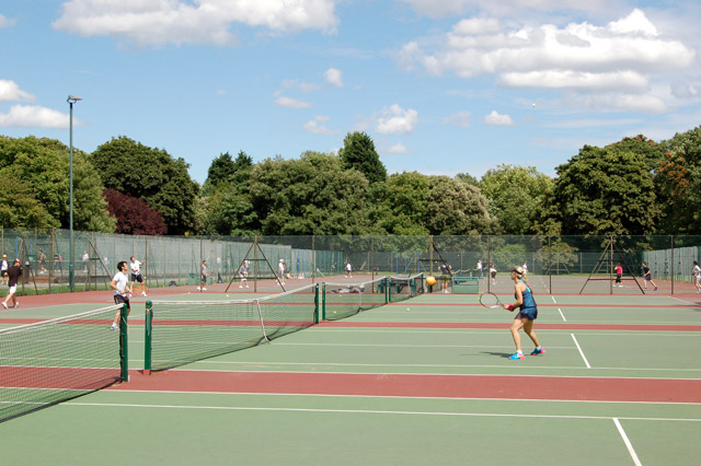
In a comment on their recent diary entry publicerination suggested that use of leisure=pitch with sport=tennis was always intended for single tennis courts. I had my doubts given that someone in San Francisco was adding quantity, and I have added pitch:count and there is also a documented tag courts. Were we just the odd mappers out?

Looking east across the tennis courts, Regents Park - geograph.org.uk - 1407669

A relatively quick way to answer this was looking at tennis courts in the UK as I have a 1-2 year old import available for Great Britain. Overpass can also be used to collect the data, but it’s not possible to calculate areas directly. I ran a query which pulled tags, the geometry and the area of each pitch in square metres and saved this first as geojson and then as a csv file.

See full entry

Location: Southfields, London Borough of Wandsworth, London, Greater London, England, SW18 5RL, United Kingdom
Posted by watmildon on 24 April 2023 in English. Last updated on 25 January 2025.

The setup

This diary is a follow on to my previous entry detailing Adding addresses with JOSM and MapWithAI. You’ll need all of the setup there plus the Conflation Plugin.

Finding a good area

The key to doing this quickly is to find an area with:

  • High quality address data with good spatial positioning
  • High density of building outlines to act as targets for the address data
  • Extremely low current address density (resolving conflicts is important but does slow you down!)

The area I’ve been spending most of my time recently is Phoenix, AZ which has great address data from the [National Address Database] and a high level of building coverage. The suburb are also quite sprawling which means you can cover a lot of very regularized ground very quickly. Here’s a good candidate for rapid addition: Aerial image of a suburb of Phoenix. The houses are laid out very regularly

See full entry

Posted by Gustavo22Soares on 23 April 2023 in English.

Versão original em português: PlayzinhoAgro está morto

Not physically dead, but I am no longer an active mapper.

For the past three years I have dedicated myself intensely to OSM and it has been an amazing experience. However, it has been exhausting and I was only able to continue thanks to the Brazilian Mastodon community.

Having so much time to dedicate to mapping has been a privilege, but recently I was diagnosed with Autism and I’m planning to move away to enter university. Before that, I will finish importing the buildings in Fortaleza and do one last address import. The data from 90 cities, including 20 with building footprint data, will be available on Github, mostly under CC0 license.

The UX/UI designs are available on Github and I will continue to maintain and improve them for a better proposal.

The OpenCollective will remain open until the end of May, when I plan to finish all ongoing projects. Currently, I receive about 170 reais (about 33 dollars) per month. To continue I would need five times that amount, i.e. about 800 Reais ($158). Unfortunately, this amount is extremely low and if I can’t reach my goal, I will have to take a break from my work with OSM and look for a paid job.

Thank you for the opportunity to be part of this community and for all the support I have received so far. I hope to be able to continue contributing in the future.

https://opencollective.com/playzinhoagro

Posted by spughetti on 23 April 2023 in English. Last updated on 1 October 2023.

I haven’t used this diary up until now, but better late than never! Figured it was time to start logging my mapping projects. :)

One of the first things I noticed when I was starting to map sport pitches in the Bay Area was the use of the quantity= tag. It was often used to map multiple pitches under one area instead of mapping each pitch individually. I’ve also seen it used to note how many of the same pitches were near each other. For example 3 basketball courts next to each other would all have a quantity=3 tag. Although I’ve seen the latter usage far less.

Mapping multiple pitches under one area makes the map less accurate, as the leisure=pitch tag is only supposed to be used for one pitch.

I’ve been fixing pitches mapped with this tag for a while when I came across them. But yesterday I learned how to use overpass turbo and now I’m able to find every pitch using the quantity= tag far more easily. I’ve been spending last night and today fixing every pitch with a quantity= tag and plan to finish fixing them in the next few hours.

Example

These 3 tennis courts were all mapped out using one tennis court area with a quantity=3 tag. In order to fix this I swapped out the leisure=pitch tag for a landuse=recreation_ground tag to turn the area into a recreation ground.

I then swapped the quantity=3 tag for a courts=3 tag, which in contrast to the quantity= tag is a registered tag on the OSM wiki.

Lastly I mapped each individual tennis court. In this case I also added a barrier=fence tag to the recreation ground.

See full entry

Location: Civic Center, South of Market, San Francisco, California, 94102, United States