OpenStreetMap logo OpenStreetMap

Diary Entries in English

Recent diary entries

Posted by nabilersyad on 15 September 2023 in English.

Thought I’d write a quick diary entry to start things out. I’ve been mapping in OSM since 2020, almost 3 years now at this point and covered many places in Malaysia. I’ll talk about those in the future.

My I have 2 major focuses now.

  1. Mapping every street in Kuala Lumpur CBD
  2. Adding satellite visible data in all of Kuala Selangor District

Kuala Lumpur

I define Kuala Lumpur CBD as all the area surrounded by the MRR1 road network. My mapping plans here are comprehensive. I would visit every single street and add as much detail as possible. However I will prioritize buildings, pavements, housenumbers, POIs, locality names and landuses. The following link visualizes how much area I’ve covered so far.

https://felt.com/map/Everystreet-KL-B4AH7To6RaiuAaKUqJBY3D?loc=3.158563,101.694303,15.72z&share=1

Kuala Selangor

The mapping here is a bit simpler. I plan to add all buildings in Kuala Selangor. Wherever I can, I will also add landuses, highways and water features.

That’s all for now. I will update every major milestones when I can.

Posted by citrula on 15 September 2023 in English.

For a while now, I have used the QA Tool OSMCha in order to observe edits happening in my local area. The saved filters allow you to create feeds of edits based on criteria like changeset location and even some validator results. Recently, I have been trying to respond to changesets in Texas which are either from new users or requested for review by the community, so I made an OSMCha filter to find those changesets. While I was using this filter, I noticed that OSMCha supports RSS feeds for saved filters!

So, I’ve added some of my most used filters into my RSS reader of choice, which has made it significantly easier to keep up with the filters without having to try to remember where I left off since it keeps track of which changesets I have actually opened. Here’s what it looks like in my reader: A screenshot of an OSMCha filter feed open in FreshRSS) Some improvements can probably be made to OSMCha to make this easier to use at a glance (such as including a simple screenshot of the bbox), but this is already great for keeping track.
See full entry

Posted by Answerquest on 15 September 2023 in English. Last updated on 14 October 2023.

Assumptions: - You’re working with a district shapefile having village polygons, and you want to add the village boundaries to OSM. (Find+replace the terms as appropriate for your use case) - Instead of separate polygons, you want each shared boundary between say 2 villages to be loaded on JOSM as a LINE shape, so that you can add it as a Way and then include it in the respective Relations of each village - So this process will help you convert those polygons into these common boundary lines

See full entry

Location: Shaniwar Peth, Pune, Pune District, Maharashtra, 411002, India
Posted by jonnymccullagh on 15 September 2023 in English.

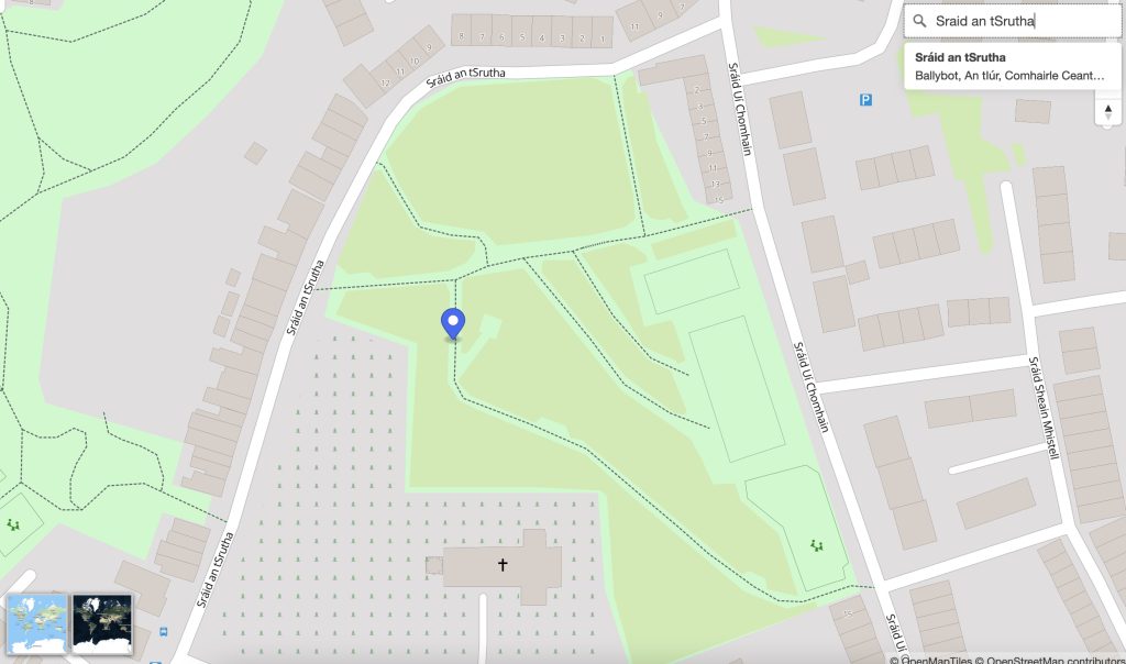
OpenStreetMap Ireland identified a need for a map of Ireland showing place names in the Irish language (Gaeilge) and to encourage more Irish language additions to OpenStreetMap (OSM). Some other mapping services show only town names in Irish when Irish is set as the preferred language in the web browser; however we wanted a map that would ‘by default’ show towns, streets and other places using the Irish place name.

We named this service ‘léarscáil’ which translates to English as ‘map’. The service is available at learscail.openstreetmap.ie Screenshot Any streets that do not have a tag for name:ga within OpenStreetMap are left blank on léarscáil – this is by-design – to encourage everyone to fill-in-the-blanks. We use official street name signs as the source for the translations.

Technical

We made use of several open technologies to solve the problem including:

See full entry

Location: Castlewilder, Agharra ED, Ballymahon Municipal District, County Longford, Leinster, Ireland

A few weeks ago, I wrote a plugin for PMTiles for JOSM. PMTiles is a web-first tile storage format which allows the provider to have a single file with all the tiles they want to share. Users can then make direct requests using HTTP Range Requests to get just the data they want. With this, other OSM users have discovered that they can run a tile server for <2 USD/month.

As of Aug 28, 2023, the JOSM MapWithAI plugin now supports PMTiles and Mapbox Vector Tiles as data sources. Please note that no tag transforms are occurring, so if you do use the data, please use the replacement tags feature of the plugin. With that said, it is theoretically possible for a pmtiles file to give us the mappings; the specification has a JSON metadata field which can have arbitrary key value mappings.

Anyway, here are some known datasets to test out this functionality (I only tested the overture-pois.pmtiles file):

As a reminder, there is a reason why the overture data has not been imported into OSM, mainly quality concerns. So if you do use it, ensure that whatever it is you are adding actually exists (for POIs) or is geometrically correct (for buildings/roads).

See full entry

Location: Grand Junction, Mesa County, Colorado, United States
Posted by umbraosmbr on 12 September 2023 in English. Last updated on 13 September 2023.

The activation of Flood Mapping in the City of Muçum, RS has begun!

As a result of the rains that affected the state of Rio Grande do Sul, Brazil, UMBRAOSM, the Brazilian Chapters of YOUTHMAPPERS created an Activation project for mapping in the city of Muçum in the state of Rio Grande do Sul - Brazil for mapping the City! !

This project aims to map buildings, so if you want to use the MapWithAI tool (Rapid or JOSM), it is recommended to use this tool mainly in rural regions with low building density. This allows you to quickly add AI-predicted buildings and roads. However, human verification is necessary. Don’t just accept auto-detected buildings - ensure correct building alignment, geometry and road classification before saving your work.

If you want to use JOSM, you must download the [MapWithAI] plugin (https://github.com/KaartGroup/JOSM_MapWIthAI_plugin#readme). The plugin wiki page contains detailed usage instructions. You can also use the [building_tools] plugin (osm.wiki/JOSM/Plugins/BuildingsTools), which will make the geometry creation process easier. Once the building has been digitized, use the “q” key to adjust the geometry. For road mapping, remember that they must be connected to each other. Additionally, generate enough nodes to avoid sharp angles when changing road directions. In the case of intersecting roads, an intermediate node must be placed at the point where they intersect, unless there is a structure separating them, such as [bridges] (osm.wiki/Key :bridge) or [tunnels] (osm.wiki/Key:tunnel).

Powered by:

Umbraosm Brazilian chapters of youthmappers HOTHubLAC Brazilian Community of Openstreetmap

See full entry

Posted by GiftedIsha1 on 11 September 2023 in English.

I honestly don’t have the words to describe the overwhelming flow of emotions that I am experiencing regarding this project.

*This a whole new experience for me and I feel so blessed to be apart of this program and would honestly recommend anyone in joining and learning about the values and endless opportunities that exist with using (OPEN STREET MAP). From the first hand experiences in my community to mapping specified areas in my country it is such a remarkable experience for the young and young at heart to widen their horizons and try new things.

Location: Jamaica
Posted by aman_bagrecha on 10 September 2023 in English. Last updated on 11 September 2023.

On September 9, 2023 Let’s Talk Spatial and OSM Bengaluru organized a mapping party in Chamrajpet, Bengaluru, India. We had 367 contributions to OpenStreetMap with 6 first-time contributors. After we finished mapping, we were #1 in the world in terms of number of edits!

photo1

The idea of organizing an outdoor mapping activity originated on the day when OSM celebrated its 19th Birthday. My social media was flooded with mappers celebrating in various different ways to show their love towards OSM.

On the last day of FOSS4G I saw mappers mapping the streets of Prizren - noting down the opening hours, contact details and much more information onto OSM. Though I missed the opportunity to map with them, I saw this could be done in my city, with the help of expert mappers.

See full entry

Location: Shankarapuram, Chamarajapete, Bengaluru, Bangalore North, Bengaluru Urban, Karnataka, 560004, India

This week continued working on the barefootstache-mapping-croatia project to align with my upcoming trip to the area.

While mapping east of Vrbanci, I noticed that I was almost done with its boundary and completed it.

before and after animation of OpenStreetMap depicting land cover addition mainly farmland, meadow, heath, scrubs, wood, and many other land covers

Quick Overview

See full entry

Location: Lazina, Mjesni odbor Lazina - Franjetići, Draganić, Municipality of Draganić, Karlovac County, 47201, Croatia
Posted by pedrito1414 on 9 September 2023 in English.

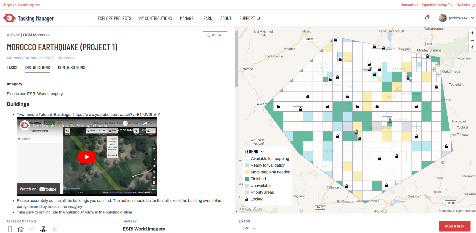
Following the earthquake in Morocco last night (08-09 Sept 2023), staff from HOT’s West and Northern Africa Open Mapping Hub and OSM Morocco agreed to launch an activation to support response efforts.

If you would like to support by mapping, please do. The first project is now on the HOT Tasking Manager and more will follow.

HOT Tasking Manager

You can also keep track via the activation wiki page : 2023 Morocco Earthquake.

If you have questions or would like to engage, you can do so via the HOT slack or the OSM community forum.

Thanks in advance for your time and skills in support!

Posted by Black_Diamond on 8 September 2023 in English.

The USGS 3D Elevation Program (3DEP) is awesome. When mapping roads, creeks and trails that are covered by trees, it’s nearly impossible to use any satellite imagery in any meaningful way. Even if someone spends the time to use GPS to track a road or hiking trail, it is even harder to find someone to walk down the middle of a lot of creeks to track the path of the water flow. It’s also not uncommon for the GPS trace to be off by several feet or even have gaps in the data near tall dense trees, which reduces the accuracy of the path being traced on a map. 3DEP can help in such situations.

three dimensional elevation program (3DEP) Logo

I believe that this data is only available for most of the US territories. So if you are mapping outside outside of the US, this may not be beneficial to use.

See full entry

Posted by prispe on 8 September 2023 in English.

On the 6th of September 2023, we the members of the committee had a review on the volume of applications submitted by the applicants for SotM Africa which is slated to be held in Cameroun this year 2923. Letters were sent to the applicants whose application was not successful.

On the 8th, we concluded were 15 of the applicants made it to the top. Letters will be sent to them by the 9th of September, 2023.

Make a Donation to UMBRAOSM Union of Brazilian OpenstreetMap Mappers and keep the site in AR and your projects!

https://www.umbraosm.com.br/doacao.html

These are the data to send a Pix to the Neon account!

To send by keys: Email: umbraosm@gmail.com

Name: Roberto Borges De Sousa

See full entry

When I started getting involved in mapping on OSM around July 2021, I asked myself: “But why hasn’t anyone made a guide to help me map this country?” and indeed, there was no specific guide to contribute on North Korea!

North Korea Mapping Guide

Beginning

After learning and integrating all the basic OSM tags (including highway=*, building=*, natural=*, landuse=* etc.) and mapping some small towns of the country, I thought about creating a personal page of recurring tags for easy retrieval.

Then the idea came to me to make a thematic page on the contribution specific to this country.

Access to the terrain in North Korea is complicated, and a good understanding of satellite imagery is essential, so a guide to the subject becomes all the more relevant. So I decided to create one!

See full entry

Location: Otan-dong, Central District, P'yŏngyang, North Korea

Being now 67 years of age I have started to think that I should get out and explore my local area. Partly to get fitter but also I have now got my free bus pass and I intend to exploit it. I have lived in Doncaster since 2016 (7 yrs). I have some knowledge of the local area obtained by driving around, but I feel its time I got out on my bicycle and explore.

Location: Carcroft, Doncaster, South Yorkshire, England, DN6 8HJ, United Kingdom