
the arch of September has its feral grip slapped free from the gators grip of October, I’m holding fast to turkeys and dipping my head in the gravy
Diary Entries in English
Recent diary entries
Posted by Wendy Achmmad Mustaqim on 3 November 2024 in English.
Year 2016.
Posted by SunshineIDR on 1 November 2024 in English.
I recently had the privilege of attending the State of the Map (SOTM) Nigeria 2024 conference in Ile-Ife, Osun State, and I am deeply grateful for the experience and the opportunities it provided. I was fortunate to receive a partial grant that covered my transportation, accommodation, and meals, allowing me to participate fully, and I am truly appreciative of this support.
The conference, centered around AI-assisted mapping, drone technology, and open geospatial tools for advancing Sustainable Development Goals (SDGs), was an incredible learning experience. The sessions led by professors, doctors, and online hosts highlighted the potential of these technologies in addressing real-world challenges.
I am especially thankful to Dr. Victor Sunday, the National Coordinator of Unique Mappers Network, for his encouragement and support in making this experience possible. The distinguished speakers greatly enriched the conference. Prof. Kamorudeen Folorunso Aleem kicked off the event with an insightful session on Open Geospatial, AI Technologies, and Geospatial Data Policies in Nigeria, which set the stage for critical discussions on data governance. Prof. Lazarus Mustapha Ojigi, the Executive Director/Professor of Geomatics at the African Regional Institute for Geospatial Information Science & Technology (AFRIGIST), shared his expertise on Artificial Intelligence-Assisted Geospatial Mapping and Modelling Techniques for Achieving Sustainable Development Goals in Africa, providing valuable insights into the integration of AI in geospatial analysis.
Cashless payments have increased dramatically lately, specially during the COVID-19 “main years”. Still, paying in cash can be crucial as a resilience method (think internet, power, banking system outages). It can be used as a great tool to slightly improve privacy. Paying in cash at a cashier usually is an option, but machines handling cash could be preferable, for example:
- Elderly people might prefer a machine handling their coins as opposed to trying to count them themselves.
- People who prefer reduced social contact.
- Cash/coin enthusiasts who prefer cash payments.
Tag payment:cash:machine is suggested to map the status here. Possible values:
- no - All cash handling happens by humans only.
- yes - Machines are available for cash handling.
- cashier - Machines are available for cash handling at cashiers (often limited to coins).
- self-service - Machines are available for cash handling at self-service stations.
Currently mapped objects in Latvia - where green indicates a present cash machine, orange - explicitly tagged “no”.
The State of the Map Nigeria Conference was indeed a unique one. Packed with a lot of excitement. When I said it was fun I really mean it. All the guest speakers both online and in person did very well and I personally learnt a lot from the conference. The conference was held from 8th to 11st of October 2024.
Posted by TheFighter137 on 31 October 2024 in English.
Last updated on 1 November 2024.
I definitely seem to love this website. Afterall, it allows me to add some facilities thanks to data provided by french government services : electricity substations, monuments, post boxes, various problems, …
For today, the main municipalities I worked on with OsmOse are Paluel, Néville, Cailleville, Angiens, Cany-Barville, etc… . I also fixed merged adresses and shops so that data is associated accordingly. I started to fix issues in the Rouen metropolis as well, however it will take a few days to finish the whole city considering its size.
Little announcement : I plan to set sort of a weekly schedule to the tasks I want to do. This way, each day of the week will be dedicated to one task in particular, and will have a special name ; for example, SamedInspector (for non-french speakers, it means that saturday would be dedicated to OSM Inspector). Also, even though I will have a weekly schedule, I will switch from 1 entry/day to 1 entry/week that will contain everything I’ve done within the last 7 days.
In Part 3 I talked about changes in POI data in a small area over a period of two months. Most of those changes were due to mapping activity, rather than anything that happened in the real world over that period. But I’d like to use a similar approach to better understand how the real-world POIs are evolving.
As I mentioned in Part 3, until recently a significant proportion of POIs in this area had never been mapped in OSM. That means there is no point in the past at which OSM data is anywhere close to a complete set of POIs for this area. But we might be able to learn something from the POIs that were mapped some time ago.
I chose to look back 5 years, to August 2019. I guessed that was roughly the point at which the data was most accurate. Most POIs were added in 2017-2018, so while lots of POIs were missing, those existing in 2019 were probably still fairly accurate. This is how those specific POIs evolved over 5 years, ignoring anything newly created over that period:
| POI count | as % | |
|---|---|---|
| no major change | 135 | 57% |
| removed | 42 | 18% |
| changed POI type | 38 | 16% |
| changed name | 22 | 9% |
| total | 237 | 100% |
Posted by Calvin Menttor on 31 October 2024 in English.
Last updated on 3 January 2025.

 …and suddenly, I woke up early in the morning just to realize that I was in Lagos on 8th October. Ask yourself what brought me here? Hehehehe… Of course, State of the Map Nigeria Conference 2024. Well, well, my journey was tiring but adventurous as well. Now, let’s double our steps to catch up with other activities. It’s a movie. Oh, sorry, it’s a story. You might need a glass of chilled water. Probably!
Welcome to Nigeria!
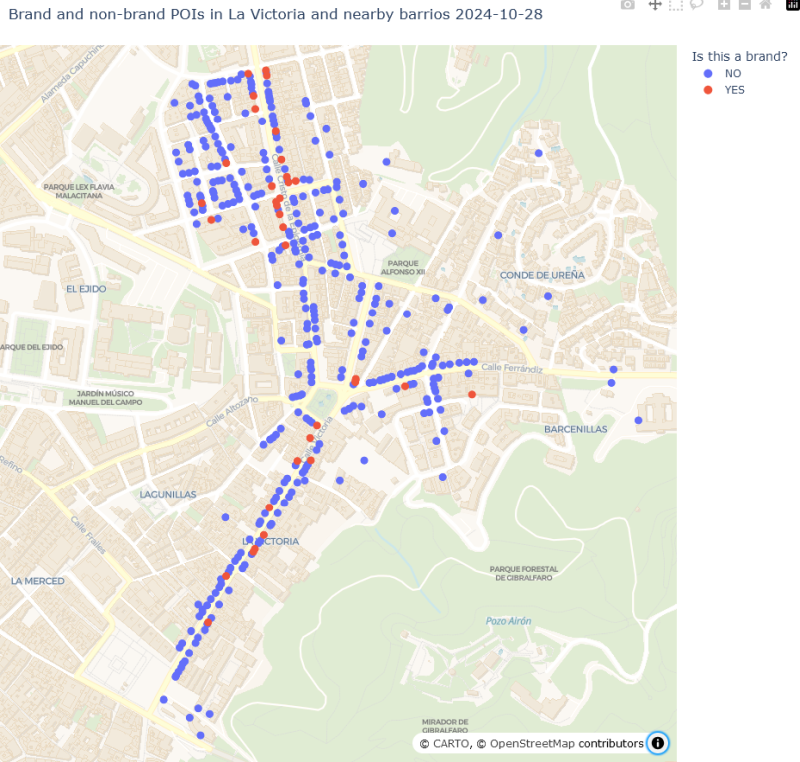
As I mentioned in Parts 1 and 2, over the last couple of months I set out to systematically update Points of Interest in four adjoining barrios in the city of Málaga.
A few businesses really did open, close, or change hands over that short period. But the vast majority of the changes in the data reflect the OSM data “catching up” with reality: adding points that had never been mapped in OSM, or updating POIs that had changed in some way since they were last touched by an OSM mapper.
Adding leisure POIs
Closely examining changes over a period is a good way of revealing faulty assumptions. I noticed that three shop locations had disappeared from my data, even though I was sure there were still businesses at those addresses. They are all gyms now, and gyms are tagged as “leisure” - a tag I had completely ignored. I’ve now added leisure POIs. As with “amenity” tags, I excluded some high-volume tags such as “garden” and “swimming pool”. I now have 392 POIs in my current dataset, not 376 as I mentioned in previous diary entries.
Changes over the period
| POI count | count distinct feature tags | |
|---|---|---|
| mid Aug 2024 | 267 | 96 |
| + newly created | 141 | 34 |
| - removed | (16) | (9) |
| late Oct 2024 | 392 | 121 |
| % change | +47% | +26% |
I mentioned in a previous post that I thought that POIs were reasonably well mapped in this neighbourhood. The numbers suggest that about two thirds of POIs were mapped two months ago. That seems respectable, but not great. There has not been any major expansion of retail space in this area recently. Some of the new additions are locations that were vacant or derelict when the area was first mapped in detail, but the majority have existed for a long time and were simply never mapped in OSM.
Posted by TheFighter137 on 30 October 2024 in English.
Last updated on 1 November 2024.
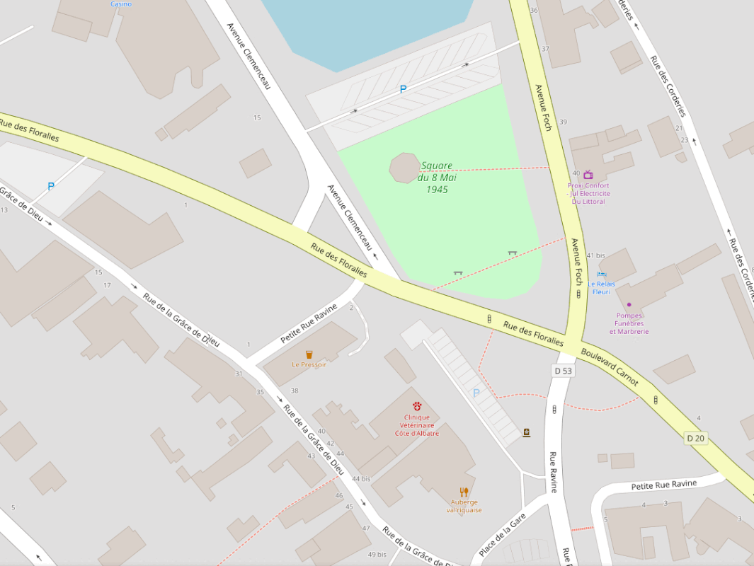
This is the first time I try micromapping in OSM. It took quite a while to learn the appropriate tags for some amenities, but I got there in the end. For a first, I decided to focus on an open area I know very well, which is a square in my hometown. I didn’t do much in terms of area coverage, but it is still pretty noticeable. By the way, if you want to check if I’ve done my job correctly, please note that less than one year ago, all hedges and trees that surrounded the square were torn down ; no idea why considering it looked awesome, now it is pretty dull and flat.
Here’s what it looks like, and considering how it is rendered, I can’t resist feeling proud :
Posted by TheFighter137 on 30 October 2024 in English.
It seems that I tend to forget to publish my daily diary entry on time ; I’ll do my best to do so, even for light workloads
Yesterday, I rode my bicycle to check on-site issues that I noticed with addresses in Saint-Valery-en-Caux. I managed to fix them all, and to map a few fire hydrants as well.
I wish to thank the OsmAnd team for their app : this diary entry was possible thanks to them and their app. Features such as audio/video notes and offline OSM notes were very helpful during this bicycle ride.
Posted by pedrito1414 on 29 October 2024 in English.
I was putting together some facts and stats* on OpenAerialMap and the open drone imagery it hosts and thought it might be interesting / useful for OSM peeps as a key user group…

In case you don’t know, OpenAerialMap is a platform for making open imagery available to people that need it.
This year the weather has been quite awful in Milan, and Sunday 20th it was raining once again. However, later during the day it was nice and even sunny, so I decided to go for another trip.
This time I planned in advance and went to Villaggio dei giornalisti, an area that was not particularly covered by previous footage. It is an area of architectural interest and particularly nice.
After that, I went back to the Parco Nord, covering more bike paths in the park.
This time I configured the camera correctly to record a time-lapse, getting around 4 GB of videos for a 2h trip, a much more reasonable file size. The battery also lasted longer, more than 2h and could have gone for much longer. I had to end my trip because it was getting dark.
Another thing I learned from the previous time was to use a fitness tracker to track my trip, so now I can see the calories and speed overall, and observe the trip later on Strava. I also could produce a GPX track, but they are already abundant on OSM in this area.
I still have to figure out an effective way to micromap based on these pictures, iD integrates with Mapillary but the interface is a bit cumbersome for large changes, currently I find easier to open another window with the footage only.
Posted by TheFighter137 on 29 October 2024 in English.
Yesterday, I worked on two municipalities : Jumièges and Saint-Valery-en-Caux, the latter being the one in which I live. I used once again the Pifomètre tool to add adresses. However, I don’t think I’ve finished everything in Jumièges, so I’ll have to work on this municipality again today.
Brands
As part of my systematic update of local POIs (see Part 1), I added the “brand” and “brand:wikidata” tags wherever I could identify them. Before I started I thought I might find quite a few POIs that I had not previously recognised as brands.
Spoiler: I was wrong, yet again. It’s good to have your preconceptions challenged by actual data. I guess.
It turned out that the reason I hadn’t heard of most of the brands displayed on POIs in this area, and the reason not many POIs had the brand tag before I started mapping, was that … they aren’t brands. It’s possible there are a few shops belonging to brands so obscure or localised that I couldn’t find any reference to them online, but I don’t think I can have missed many.
Out of 376 POIs, only 36 - less than 10 percent - are now tagged as brands.
Recently I have been trying to systematically improve OSM data about shops, businesses, and other Points of Interest in a small area of my city. Like many OSM contributors before me, I have been torn between the desire to make my local map as complete as possible, and the realisation of just how much time is needed to do that. My observations in the following series of diary posts may not be very original, but perhaps they’ll help me to clarify my thoughts on the subject.
Background
Málaga is divided into about 200 barrios or neighborhoods, all with well-defined boundaries in OSM. I chose to focus on an area of four adjoining barrios slightly to the northeast of the historic centre. The main axis of this area, formed by Calle Victoria and Calle Cristo de la Epidemia, is about 1km long (the green dashes in the map below). These main thoroughfares, and many of the smaller streets, are lined by apartment blocks with commercial premises on the ground floor. The hillier areas to the east are more purely residential. Most shops are quite small, many are sole traders, and there are no shopping malls.
Dear Diary,
Now I know what your thinking, “what kind of boy has a diary”. Its NOT a diary, remember that reader. Its a INTRICATE PROGRESS LOGGING DEVICE that is mine and mine only! Yeah, i guess you could say its a kind of “Dairy of a Wimpy Kid”, heh! Well thats awkward… Nettspend Out!
Posted by TheFighter137 on 27 October 2024 in English.
I finished solving my personal OSMose issues (mainly level 3) and other ones in municipalities around Saint-Valery-en-Caux.
To correctly tag some services, I needed to use Pifomètre for two municipalities.
I also fixed a few issues in OSM Inspector around Saint-Valery-en-Caux and Rouen, although it is pretty difficult to understand what’s wrong sometimes.
Another OSM user rightfully told me that one edit I did on bus lanes in Rouen was wrong in terms of tags, so I managed to correct it.
Posted by manojkmohan on 27 October 2024 in English.
You may know that the preparations for this year’s OpenStreetMap Kerala Annual Meetup have started. We had a meeting on the 20th to find a suitable venue and date and to brainstorm related matters and form a working group for the same.
![]()
It has now been decided to hold the annual gathering of 2024 on November 16-17 at Kerala Veterinary and Animal Sciences University, Wayanad district.
Venue and Registration - Travel Scholarship - Participatory details will be updated by the responsible volunteers in the coming days.
Posted by TheFighter137 on 26 October 2024 in English.
I decided to fix, once again, all of the issues attributed to me by OSMose. I managed to fix almost all of them for levels 1 and 2. I’ll probably fix the level 3 ones tomorrow.
Today, I also discovered the OSMose map. I already knew about the website itself, but only on its personal list form. Therefore, I decided to fix almost all the issues in my hometown, Saint-Valery-en-Caux. I briefly also fixed issues in Rouen and Barentin.
I won’t add the links of my changesets anymore, as I’m too lazy to do so (lol).