OpenStreetMap logo OpenStreetMap

Diary Entries in English

Recent diary entries

Finished result:

https://www.youtube.com/watch?v=xUkLQj29vE4

Preamble

I have been interested in making “before and after” comparisons of mapping progress for a while. The rich and beautiful OSM-carto style as it appears in standard OSM is a particularly important element of what I wanted to achieve, but it remains quite difficult to render historical map data in this style.

This guide mostly follows the ohsome guide from 2018 but taken further and with updates. Please be aware that I have done little to optimise the workflow so far; this is more of a proof-of-concept at the moment.

I started out mapping in August 2020 and mapped almost exclusively in my old hometown whilst I was stuck there during COVID. I spent a lot of time mapping this area very comprehensively and wanted to visualise my work. Big shoutout to user John Bek who greatly helped with building tracing, which is quite tedious. The Blue Mountains towns of Katoomba, Leura and Wentworth Falls featured are now some of the most comprehensively mapped in Australia.

Previous method

See full entry

Location: Leura, Sydney, Blue Mountains City Council, New South Wales, 2780, Australia

An sve01 / svwd01 vector map

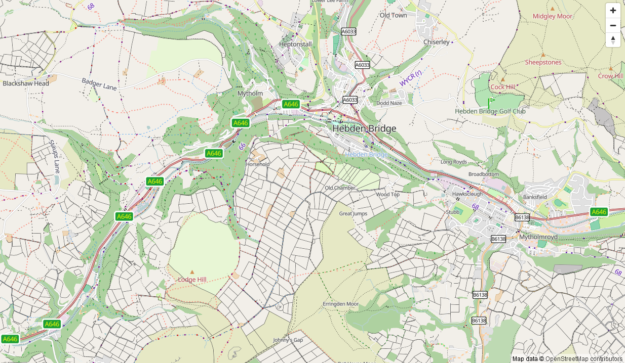
For some time I’ve been looking after a raster map style that’s designed to be a useful “England and Wales rural pedestrian” map, and also to showcase some of the richness of data that might not be obvious from basic “general” map styles such as the ones on OpenStreetMap.Org.

A goal for some time has been an offline version of that map style. At any useful level of detail that requires different technologies to be used, and the first parts of that - a vector map schema and a web map style - are now available (though not yet available offline).

The online version of that map is available here. It’ll take a couple of seconds to appear.

How vector maps work

See full entry

Location: Erringden, Calderdale, West Yorkshire, England, United Kingdom

Preface

I created this template to aid project co-ordination in tasking managers, and contributors seeking feeback. It has gone through several iterations; this is the one that I currently use. I think that there will likely be some alterations, because I see some potential impovements, though I haven’t yet received feedback regarding it from mappers.

Following interest in the template I use for validation comments from other validators, I am going to share the current version I use in this diary entry. Please, try it out and share your ideas, experiences, and results.

The template is formatted using Markdown.

Thank you to anthaas for the idea of publishing a diary entry about it.

My experience is in using the HOT TM so there may be some idiosyncratic parts which should be modified to be accurate/function within whichever TM is being used.

I have not yet seen what if any impact this has on 3rd pass validation.

Design Rationale

It was over two years ago now that I (in)validated my first tasks on the HOT tasking manager. I took a break from that until ~ 7 months ago when I started validating some more tasks here and there. Then ~ 4 months ago SColchester put me onto a good project for a beginer validator, and after that I was validating tasks at a significantly greater rate. It was also his comment on a previous diary entry of mine that insired a change in this temlpate.

After (in)validating a greater number of tasks via the HOT TM, I soon found that I was repeating myself quite a lot. For instance, linking to learning resources, events and thanking users for their contributions was very standard. I didn’t exactly fancy writing the same thing over and over, and I wanted to reach more contributors, so I decided to create something that’d make the process more efficient and idealy result in a higher quality of contributions.

See full entry

Posted by dpschep on 9 November 2024 in English. Last updated on 25 January 2025.

In January, I introduced Overpass Ultra v2 and then in June I provided some updates. Today I’m excited to share that Overpass Ultra is now simply Ultra(v3) as it has evolved beyond simply being an Overpass client into a general purpose MapLibre GL JS IDE.

Since my last update, the following features have been implemented, culminating in the release & announcement of Ultra:

  • More extensive documentation
  • The concept of query providers
  • Auto-sorting of paint and layout layer styling directives
  • Fallback glyphs
  • Bundled icons as named sprite sheets
  • HTMLControl to add custom controls, including titles to a map

📘 Documentation

At the end of June, I announced overpass-ultra.us/docs on Mastodon. In addition to basic documentation about Ultra, it includes many Examples which are focused more on Ultra’s capabilities than the specifics of quering Overpass as there are already many resources for how to do that. It also includes a MapLibre Examples section which includes ports of many MapLibre GL JS Examples to help demonstrate Ultra’s capabilities as a MapLibre IDE rather than as an Overpass client.

⚙️ Query Providers

If you’ve kept a keen eye on the afforementioned docs, you’ll have noticed that you can specify the query provider with the type key in the YAML frontmatter

Ultra’s Overpass API support is now merely one of many query providers that are supported. Ultra now implements query providers for the following:

📄 JSON & XML GIS file formats

The geojson, kml, gpx, and tcx providers all work by simply specifying the contents of a document or the URL to a document as the query body.

For example, an in-line GeoJSON query doc (Load query in Ultra)

See full entry

Posted by Pieter Vander Vennet on 9 November 2024 in English. Last updated on 13 June 2025.

Hey all,

If you want to verify your OSM-account and get that nice badge, this is possible.

UPDATE: since june (or was it may?) 2025, the OSM website introduced “social links” in the user profile. You can link your mastodon account in there and save. (*)

Then, on your Mastodon-account, go to Preferences > Public Profile. Under ‘extra fields’, set ‘OpenStreetMap’ to the left and a link to your account to the right.

(*): Previously, one had to add a html-link with rel="me" attribute into the user profile.

Calling all passionate mappers, open data enthusiasts, and geospatial innovators!

We’re thrilled to announce that the State of Map Kerala 2024 is just around the corner, and we’re extending the deadline for our Call for Proposals!

Do you have a story to tell? An OSM mapping project to showcase? Expertise in open data or geospatial technology to share? We want to hear from YOU! SotM Kerala Call for proposals extended

This is your chance to:
* Inspire the OSM Kerala community with your insights, experiences, and skills.
* Connect with fellow mappers and build valuable connections.
* Showcase your work on a platform dedicated to open mapping and open data.

We’re looking for proposals for:

  1. Lightning Talks (7 minutes): Short, impactful presentations to spark discussion.
  2. Talks (20 minutes): In-depth dives into specific topics related to OSM, open data, or geospatial innovation.
  3. Workshops (120 minutes): Interactive sessions that provide hands-on learning experiences.

See full entry

Location: Pokkode Diary Colony, Pookode, Vythiri, Wayanad, Kerala, 673576, India

OpenStreetMap; State of the Map Kerala 2024

The organizing committee meeting and Welcome Commitee formation will be held on 8/11/24 at 4 PM at the Veterinary University, Pookode, Wayanad. SotM Kerala - Formation of a Welcome Committee Following this, a basic OSM training session will be organized for students of the College of Veterinary and Animal Sciences and NSS volunteers.

Everyone is welcome to attend the meeting.

Location: Pokkode Diary Colony, Pookode, Vythiri, Wayanad, Kerala, 673576, India

It was a bright sunny afternoon in Ohio, but it was getting hard to tell from the smoke in the air.

Our Volunteer Fire Department was dispatched as mutual aid to fight a brush fire that had already burned dozens of acres. Once we got to the staging area and offloaded our brush unit side by side, I hopped in the shotgun/co-driver seat and we ventured into the woods to slowly find our way to the fire. Cell reception became practically non existent as the already mediocre network got bogged down by residents checking on each other. With sat imagery unable to load I thought OSMand and it’s offline data would be able to help us out.

We were making our way past a large pond that would prove to be a vital real world landmark for our vehicles moving to and from the fire. Even though land use was mapped I couldn’t see any useful terrain features. At one point in the past an OSM mapper simply marked the whole area as a big block of “Natural Wood” and moved on. I had to manually pin the landmarks in OSMand to give us bread crumbs to follow.

After a few hours and several hundred gallons of water being shuttled to the fire it was getting dark, but we could see the flames were no longer making progress. A county drone was now buzzing overhead and the operator confirmed that the fire was blocked by a swathe of wetlands. More fire units were stuck on the other side of it since it seemed like the fastest way to the fire from the opposite street, and they had to find their way around.

See full entry

Posted by SColchester on 7 November 2024 in English. Last updated on 12 November 2024.

Missing Maps turned ten years old in November and it may be running a full-blown internship in its tenth year.

Partially to celebrate this tenth birthday Missing Maps member organizations met for two full days in September in Nairobi, Kenya.

2024 MM Gathering
Vojtech Rehak (MSF) top left presenting on day one of the gathering, clockwise onwards around the table: Jorieke Vyncke (MSF), Benjamin ‘Benni’ Herfort (HeiGIT), Nash Naufal (MSF), Paul Knight (British Red Cross), Zacharia Muindi (Map Kibera), Rory Nealon (YouthMappers) and Sam Colchester (HOT) taking photo

What we talked about


A Short History of Missing Maps … the Last Ten Years

We reflected on the fact that on 5 November 2014, HOT, American Red Cross, British Red Cross and MSF launched the Missing Maps Project. Originally stating:

See full entry

Posted by Geojay_gis on 6 November 2024 in English.

It was a memorable moment for me attending State of the map Nigeria 2024 conference as I was opportune to meet and engage with professionals and volunteers from different backgrounds.

FROM ZARIA TO ILE-IFE

All the away from Zaria in Kaduna state, Northwest of Nigeria down to Ile-Ife in Osun state, Southwest of Nigeria for State of the map Nigeria 2024 conference. Since it was a long Journey I had to stop at Lokoja, Kogi state for a day. The following day I continued the journey down to Ile-Ife, Osun state. The venue of the conference was at African Regional Institute for Geospatial Information Science and Technology (AFRIGIST) inside Obafemi Awolowo University, Ile-Ife, Osun state, Nigeria.

THE OPENING MAPPING PARTY

It was a good beginning starting the programme with an opening mapping party. The opening mapping party started around 6:39pm with the introduction of attendees. A welcome address was done by Dr. Victor Sunday who welcomed everyone to the opening mapping party. Thereafter, the session was handed over to Mr. Calvin Menttor from Ghana who introduced the attendees to OpenStreetMaps.

Activities accomplished in mapping party

  1. OSM account opening
  2. Downloading and installation of JOSM
  3. Linking of JOSM with OSM account
  4. JOSM setup and plugins installation
  5. Building mapping: Project 657 (Nigeria- Mapping Missing Roads and Buildings in Ilesa) was done
  6. Uploading of mapped layer to the OSM server The chairperson in person of Dr. Victor Sunday concluded the session by giving the history of OpenStreetMap and how it became global. The mapping party came to an end by 9:45pm

DAY 2 OF THE CONFERENCE

The programme started by 9:35am with an opening prayer followed by the singing of the national anthem. The introduction of guests to the high table was done and the opening remarks were given by Prof. Lazarus Mustapha Ojigi. The welcome address and the goodwill message were delivered by Dr. Victor Sunday.

Key activities for day 2

See full entry

A while back I had taken a look comparing my local OGL to others in our area that were approved and listed on the wiki. Noting the similarities to existing documents I added our local cities as well per their attribution requirements. This differs slightly from documentation the that the legal working group has produced here https://osmfoundation.org/wiki/OGL_Canada_and_local_variants

I’ve not heard back from the legal questions email with my question after a few days now. But wanted to keep productive and provide supporting due diligence I am able to help out on. This seemed like a reasonable platform to use for such.

Comparing the latest “reviewed and approved” OGL from Guelph https://explore.guelph.ca/pages/open-data-license

To Edmonton and Calgary which are in turn based on the Alberta licenses. https://data.edmonton.ca/stories/s/City-of-Edmonton-Open-Data-Terms-of-Use/msh8-if28/ https://data.calgary.ca/stories/s/Open-Calgary-Terms-of-Use/u45n-7awa/ https://open.alberta.ca/licence

The majority of the documents and verbiage are identical, the differences i am able to note are as follows:

  • Preambles differ slightly for each document; however all roll up to the OGL - Canada
  • General formatting
  • Call out to relevant local attribution, acts
  • Alberta, Calgary and Edmonton add an additional exemption for “Information or Record that are not accessible under applicable laws” with an extra definition for “Records” pointing to the Alberta freedom of information and protection of Privacy act. Guelf (and others) directly reference the act as “information not accessible under the municipal freedom of information and protection of privacy act”

See full entry

Location: Rossdale, Central Core, Edmonton, Alberta, Canada

We’re thrilled to announce that our OpenStreetMap Kerala Annual Community Meetup 2024 has now been officially branded as State of the Map Kerala 2024! Heartfelt thanks to the OpenStreetMap Foundation for swiftly approving the license—this may be the first time a regional State of the Map is hosted in India, and possibly even globally!

State of the Map Kerala 2024

Event Details

  • Location: College of Veterinary Science, KVASU, Pookode, Wayanad, Kerala, India
  • Dates: November 16-17, 2024

This year, we’re excited to partner with Meta, FOSS United, TomTom, DhiSigma Systems, Kerala Veterinary and Animal Sciences University (KVASU), and National Service Scheme. We’re also grateful for the support from Sahya Digital Conservation Foundation, Geominds, and community partners Wikimedians of Kerala User Group, OpenDataKerala, Swathanthra Malayalam Computing Community, and the OpenStreetMap India Community. Updated List availabile here.

See full entry

Location: Pokkode Diary Colony, Pookode, Vythiri, Wayanad, Kerala, 673576, India

If you have some expertise the problem of correct rendering of border disputes and some spare time, then your help is welcome. If not, than of course you are welcome too!

Therefore I opened a discussion on this topic: https://community.openstreetmap.org/t/border-disputes-inconsistency-in-data-and-redering-who-can-help/121126/5

Posted by tyr_asd on 3 November 2024 in English.

Attending the recent hack weekend in Berlin, I got inspired to work on a neat feature in overpass turbo. Honestly speaking, in the past few years, the tool did not the amount of attention from the developer’s (my) side that it deserves. What came clear to me at the hacking event is that a lot of people still use it on a very regular basis and that it is an invaluable part of the OSM bag of tools, which was really nice to hear.

Auto Styler (beta)

So, what someone proposed was to extend the current query wizard feature to also support the styling of the results using mapcss. What I took from that suggestion was that it should not be hard to implement a dedicated helper dialog that auto-generates MapCSS to style the data according to the values of a selectable tag and color palette. And I’m glad to say that after a quite productive two days, there’s now already a beta version already available to test out on overpass-turbo.eu.

Screenshot of the dialog of the new auto styler dialog in overpass turbo.

See full entry