HIII!!! happy new year! i’ve decided to try an maintain a editing streak for the entirety of 2025 and it’s going pretty well (at time of writing i’ve edited daily since december 25th of 2024)! nothing much aside from that i just try to use streetcomplete when bored lol
Diary Entries in English
Recent diary entries

Starting the new year with milestone achievements! In this 22nd development update, we’re excited to present comprehensive mobile support improvements across OpenStreetMap-NG. We’ve also reached critical development milestones that put us on the final stretch toward public beta testing.
🔖 You can read other development diaries here:
osm.org/user/NorthCrab/diary/
⭐ This project is open-source — join us today:
https://github.com/openstreetmap-ng/openstreetmap-ng
🛈 This initiative is not affiliated with the OpenStreetMap Foundation.
Video Summary
This week’s video demonstration focuses primarily on our mobile interface improvements. Through practical examples and side-by-side comparisons, I showcase how OpenStreetMap-NG elevates the mobile experience.
⬇ Click the image below to play
4th Jan 2025 and 10 Million, nodes that is, I’ve set, dragged, deleted as at yesterday and the 2 days downtime broke the 1500+ days series of uninterrupted mapping. Here’s to the next.
April 1, 25 , really, and we’re on 11 Million, 3 months near exactly or 11,111 nodes a day, keeping me from the streets away.
As time passes I am delving further into the discovery that I outlined here, and contextualised a little more here and all relating to the Fingal task set up by myself and the osm community three years ago.
In quantum of the problem there are new data available from the Heigit counting service. This shows that as the validation continued up to the 18th December 2024 when the task was a year old an additional 14 thousand missing buildings were added.

Looking further into this missing building set it is distributed as follows by building tags:
*building=shed up 3700
*building=garage up 1800
*building=farm_auxiliary up 200
*building=service up 58
*building=ruins up 56
There is also some re-tagging of building objects from the building=yes tag, which mappers were requested to attempt to do.

Since yesterday, we’ve updated our Map of Mithraea using OpenStreetMap and Leaflet – and we’re quite pleased with the result!
If you’re interested in archaeology, ancient Rome, or Indo-European traditions, we invite you to explore it here: https://www.mithraeum.eu/tabula
Vale, The New Mithraeum
Posted by Calvin Menttor on 3 January 2025 in English.


On the 22nd and 23rd of November 2024, I visited the Ho Technical University (HTU) YouthMappers chapter for an exciting two-day program sponsored by OSM Ghana. These two days were not just about mapping but about igniting passion, fostering collaboration, and sharing stories that inspire.
Day One: Presentations and Knowledge Sharing

I’ve deleted OSM node 151352138 which was place=hamlet name=Dominion within the city of Longmont, CO.
It looks like this node was (automatically?) added to OSM based on USGS GNIS feature id 178314. This GNIS feature 178314 includes the following, my emphasis
- Class: Populated Place
- Feature code: Unincorporated Place
- Description: railroad siding
- Entry Date: October 13, 1978
I’ve lived in Longmont since 2008, and I’ve never seen or heard anyone refer to this location or area as “Dominion”. This GNIS “railroad siding” feature should never have been added to OSM as a place=hamlet. I checked current aerial imagery, and while there is a BNSF railway line nearby, there is definitely (no longer?) a siding near this location.
So in changeset 160974302 I’ve deleted OSM node 151352138 which was place=hamlet name=Dominion
Earlier today I OSM-stumbled upon a stele marking the western front line of the First World War in Belgium and France. In Dutch we apparently call them demarcatiepalen, a term which I find amusingly technical sounding. In French they’re often called les bornes Vauthier, named after the veteran who took the initiative of erecting them. Carved from pink granite, they stand about a metre tall. There’s a whole line of them, but I noticed that they could use a lot of work, so that became my project for this evening.
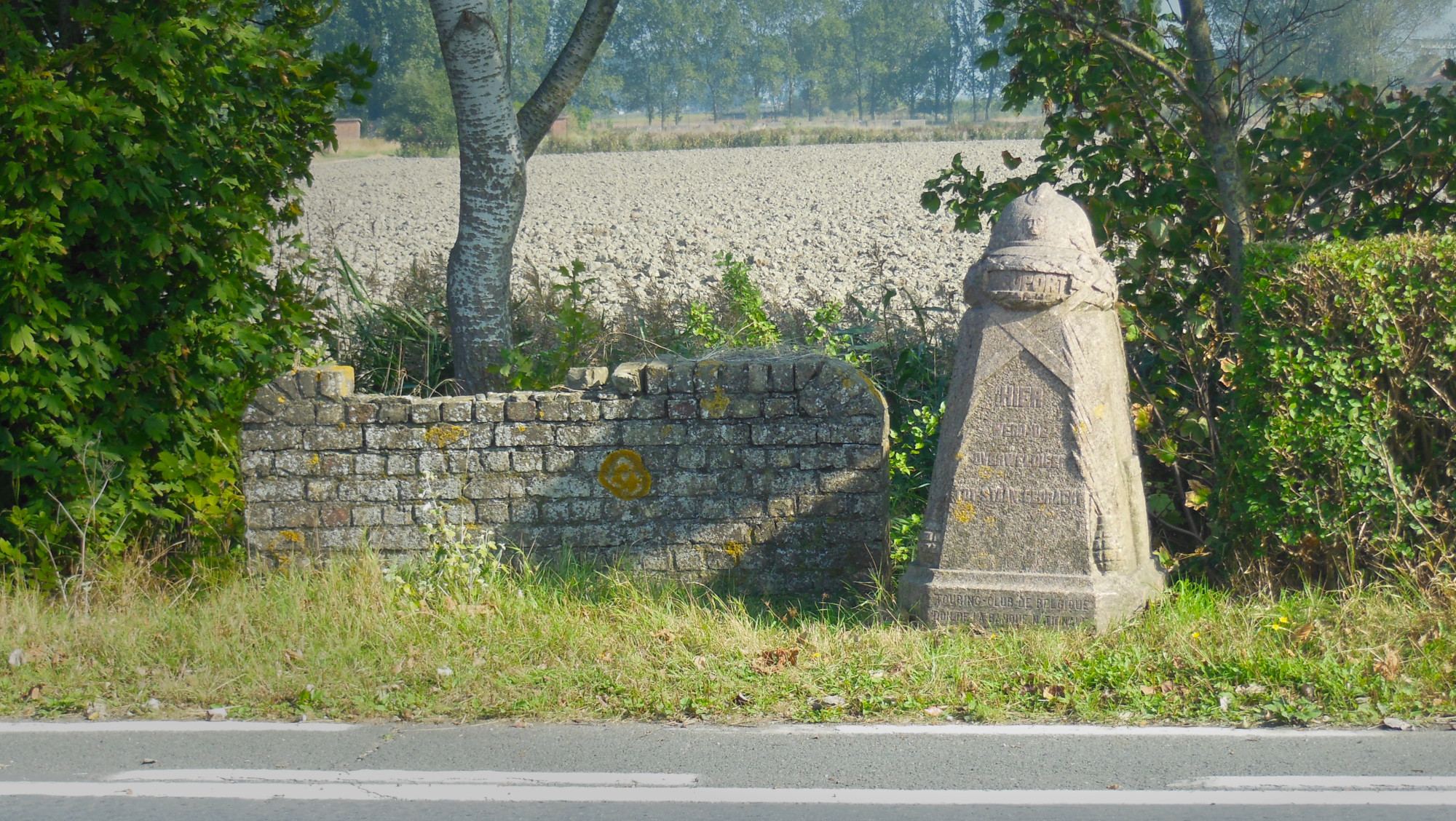
After a few hours’ work (including some distraction due to nearby unmapped stables), the 19 extant Belgian steles have all been found, added and homogenised in OSM and referenced to the database of Onroerend Erfgoed, the heritage agency of the Flemish government.

This last 5 years I have been faced with a terrifyingly real and all consuming gang stalking problem (concept which I didn’t even fully believe in until at the grips of it myself), bringing with it cognitive dissonance, dissociation and confusion through gas-lighting, bullying, financial and emotional abuse by those who are supposed to be closest to me.
it feels like I have lost all sense of footing; like solid ground could very well turn out to have been ocean this whole time and it would not be all that shocking.
My participation in this project is an attempt to help me reconnect with myself and my surroundings
By deliberately noticing everything it encompasses, and by thoroughly researching each of it’s composing elements to be able to represent them with as much fidelity as possible, I hope to regain some sense of direction and purpose and find refuge from stagnancy, isolation and depression.
Hi, my name is Joh,
and I will stand strong and make best of this, and every situation.
I shall bend not break,
I shall be,
Because I have as much right to do so as everyone else.
This is the developer’s diary concerning the fifth year of the damn project – the project that helps mappers by dividing a big area into smaller planar shapes that people can map together.
The damn project is currently used by few mappers as a tool for tracking personal mapping. (Does it make it a competitor to the SimpleTaskManager?)
In 2024, we had some problems:
-
We had performance issues when working with more than 300 000 squares in a single area; we solved these issues by pagination and forbidding creation of areas with more than 10 000 squares.
-
The damn JavaScript clients confuse mappers and we need to be serious about it; we will address this issue in 2025, but it’s not yet decided how. We are open to ideas!
2024 did not bring much to the damn project, though there are some highlights:
-
Probably no suprise that we moved to OAuth2. The amount of work is
-21lines of code. We welcome such changes. -
I wrote Unofficial design documents for HOT Tasking Manager.
The original intent of the damn project was to show that HOT Tasking Manager (HOT TM) can be done better. To help HOT TM developers, last year I wrote Unofficial design documents for HOT Tasking Manager. There is (obviously) more reasoning and comparison than in the damn server dev doc, but I don’t think it will help anyway. There is too much work and I saw the HOT TM source code. It’s unmaintainable, in my opinion.
-
We implemented enforce divide to squares function when creating new area.
If the (area’s GeoJSON)’s FeatureCollection has member
'name'then divide to squares function is NOT used. In such a case it’s expected you already divided the area – this is for compatibility reasons with MapSwipe. enforce divide to squares overrides this behavior, enforcing the division of the area to squares even if the'name'member is present in the GeoJSON’s FeatureCollection of the area.
And finally, the plan for 2025 – there are two main things:

Hi all,
In 2025, we have plans to integrate [Relocate.me]{https://relocate.me} with OpenStreetMap to rely on contributions from a global community of mappers, ensuring it is updated frequently.
More to come!
2024…I’ve learned a lot of things…
- I mapped some trees at my university.
- I love nature! So I helped @Ludway map his school with some kids. There, I practiced my knowledge of trees and species. I learned how to measure a tree! Also, I learned about some botanical things.
- I mapped my neighborhood and learned how to map buildings, shops, paths, etc.
- Now I’m envolved in YouthMappers, and I’m very proud of that.
- I met amazing people like @AngocA, @JuanMelo and @se_bras , who have taught me many things about the GIS and how develop proyects.
This was a great year, I hope next year will be better!! :)
Posted by Hans Thompson on 31 December 2024 in English.
It has been a productive year for me on osm yet I am still reaching for a more comprehensive map of both Anchorage and greater Alaska.
Mapping Natural Features
This year I continued to map large swathes of natural features in Alaska. It is still very much an open canvas to add features and without even a goal in mind it has been easy and quick to add large areas in small osm breaks throughout the day in 2024. Corollary studies published this year on the prevalence of Alzheimer’s based on occupation points to reduces occurrences with jobs requiring constant active direction finding (ambulance drivers and taxi drivers in particular). It’s been hypothesized this is from activation or stimulation of the hippocampus. That’s something I imagine I can trigger to some degree with mapping that I wouldn’t get from my typical computer work. I feel as though osm is keeping my brain sharp at least.
My First 2025 Goal

TODO
Posted by b-unicycling on 31 December 2024 in English.
Last updated on 1 January 2025.
As I wrote some time ago, I started mapping (remotely) in Indianola, Iowa. I have now reached completion (as complete as it can be with the imagery available) with buildings and added more street furniture, minor highways etc.
In total, I added or modified 6,428 buildings.

Well over a year ago I extracted all the amenity=pub objects for Great Britain. Nearly 860 keys are used across all the elements. I’ve spent some time delving into these keys, trying to classify them, and hopefully learn a bit about two things: the kinds of information people want to know about pubs; and why synonyms exist for certain keys and tags. I’ve been prompted by SomeoneElse’s list of building tags.
 A pub which I recently edited on OSM adding
 real_fire=yes.
‘Home’ now listed as a point
Posted by Bayazid Ahmed on 29 December 2024 in English.
Last updated on 27 January 2025.
📅 Date: 30-1 November 2024 🌍 Location: Cox’s Bazar, Bangladesh 🏷️ Hashtags: https://www.facebook.com/hashtag/sotm2024?__s_fcid=6811183504691807194&__s_fbid=1115079362841034 #OMGuru #YouthMappers #EasternUniversity #OSM #MappingForChange #GeospatialRevolution
🌍 A Journey of KNNOrganization, Collaborate, and CONNECTION Besides being a conference the State of the Map Asia 2024 in Cox’s Bazar was an experience that made me feel I am an empowered and global mapper. Held from November 30th to December 1st, 2024, this event truly captured the essence of its theme: “Unite, Inspire, Innovate.” And the best part? I was awarded the Certificate of Participation upon my active participation in this amazing campaign!
🔥 Day 1: 𝐈𝐧𝐬𝐢𝐠𝐡𝐭 𝐃𝐢𝐬𝐜𝐮𝐬𝐬 𝐚𝐧𝐝 𝐊𝐞𝐲 ℚ𝐮𝐞𝐬𝐭𝐢𝐨𝐤 The first day of the map conference State of the Map Asia2024 started with a brilliant and inspiring keynote by Said Turksever from Mapillary&@Meta. His insights into the future of mapping technologies were nothing short of captivating, especially when he raised these two crucial questions: 1) Does Mapillary have certain regulations, or limitations on what and where users can record via their application? 2) What are the further objectives of the Mapillary platform and what updates are further expected from it? These questions raised debates regarding the ethical issues within and the future possibilities of such platforms as Mapillary, thus promising a highly stimulating tone for the whole conference.
A few years ago I started working to make my town, Glenrothes, more visible on the Open Street Map. Mostly it was just roads and land use imported from public data, though a few people had added in some housing areas, addresses, and point of interest. I have steadily been adding all the missing buildings, shops, addresses, other missing POIs and cleaning up major land use blocks.
It is far from perfect, but things are in a much better state than they were a few years ago. But there are still a few areas where data needs to be added. If possible, it would be nice to address these in the coming year:
- Finish adding the remaining missing addresses - There are a lot of neighbourhoods still missing address data. The UK’s PAF still hasn’t been released under open license, so these will need to be surveyed and added manually. In clockwise order: Collydean, Pitcairn, Balfarg, Cadham, Markinch, Thornton, Stenton, Caskieberran, Stenton, and Leslie. I want to be accurate though, and the layouts of houses in same areas can be difficult to navigate, so it may take some time.
- More details for POIs like shop opening hours - Locations on the OSM can have additional metadata like contact details, opening hours, whether they are disabled accessible, and things like types of menu for restaurants. Some of this info is made available on websites, some of it may need direct surveying.
- There are lots of construction areas around town that will need to be surveyed when they are complete. New buildings and POIs to be added. The town park is also being upgraded and when it is finished next year there may be lots of changes to update, like new paths and play areas. Some of these changes have already been updated.