Posted by Raquel Dezidério Souto on 30 April 2025 in Brazilian Portuguese (Português do Brasil).
Last updated on 7 May 2025.
Users' Diaries
Recent diary entries
Cross-posted from https://odeco-research.eu/?p=4999
On Thursday, the 10th of April 2025, we celebrated the event “OpenStreetMap: Mapping & Hiking” at the University of Camerino, Italy. After two months of preparation, the event was well-received and had a diverse and satisfied crowd.
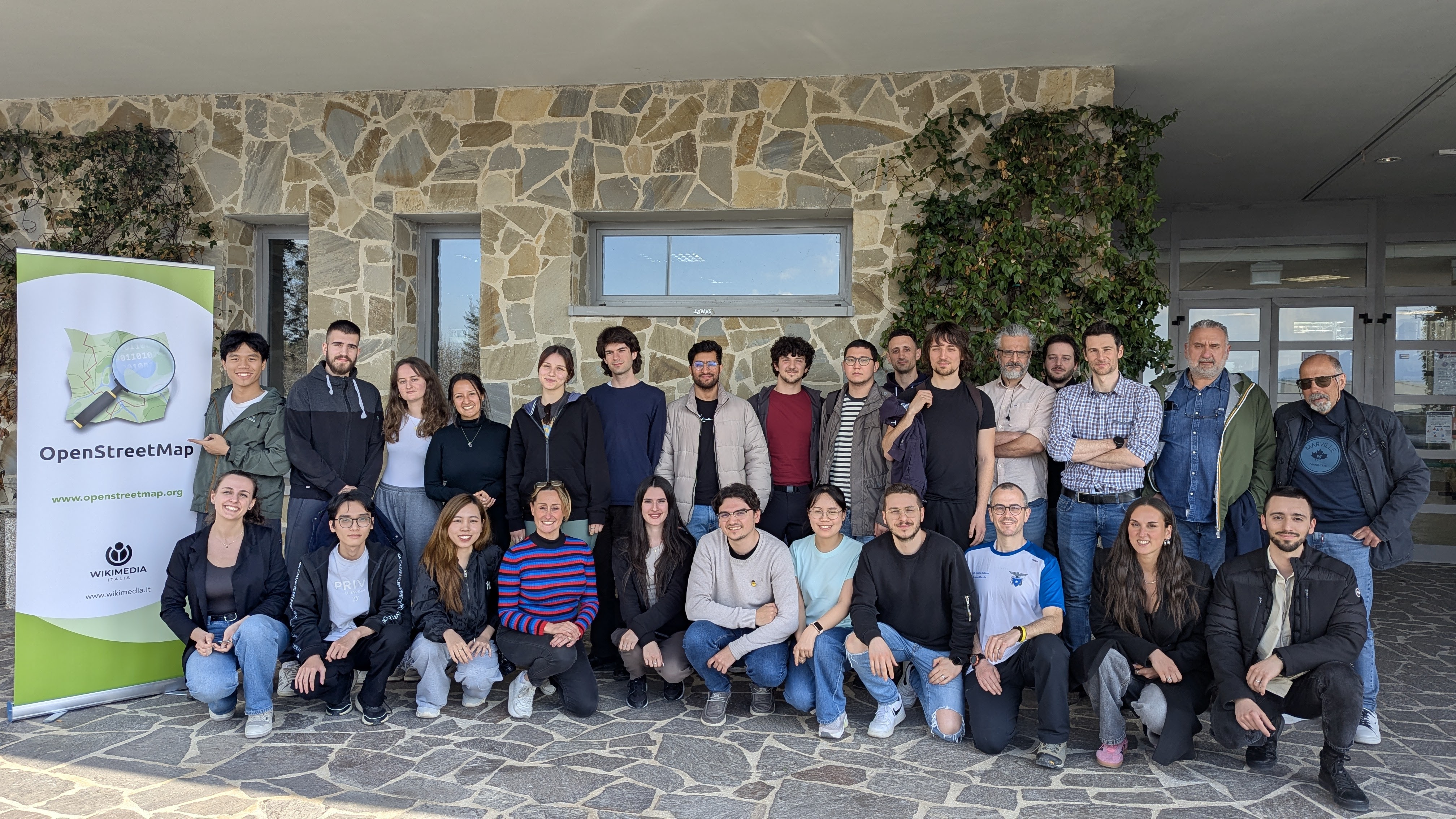
OpenStreetMap (OSM) is a collaborative geographical database of the world. Millions of people use its data, and also millions contribute to it in various ways. However, there are still places where there is no strong local community, where its villages and rural areas are heavily undermapped. Camerino, while the town itself is well mapped, has some incredible nature and cultural spots nearby, which needed an update. As well, being a university town with students coming from all corners of Italy and the world, makes it a prime location for engaging in outreach activities and kickstarting a community.
How complete are addresses in OpenStreetMap in Belgium? After several status these previous years (see September 2022, in May 2023, and in May 2024, November 24), I finally adapt the process to analyse addresses completeness for all Belgium!
The aim of this small article is to assess the completeness of addresses in Belgium for OSM, compared to official data. Basically we count the address points in OSM and in official data by municipalities. We don’t check the address quality here, we know there can be errors in OSM data, and even in official data.
How I proceeded
Using QGIS, I gathered OSM addresses and official ones. OSM data is imported in a PostgreSQL database using osm2pgsql based on a pbf file for Belgium from the 24th of April. Official data is coming from BEST address csv files, that gathers Belgian addresses for the 3 regions of the country.
Addresses in OSM can be mapped on buildings (most of the cases), hence on a way, or on a node. I consider only objects with the “addr:housenumber” tag. First, I made a single layer of addresses points from OSM data by merging the centroids of buildings with this tag and the points with these tags, by excluding the places where these two layers overlaps (typically points with an address inside a building where there is already an address). The method is far from perfect: I don’t consider relations, I miss some way objects with addresses but without the building tag (typically some schools), and probably a lot of other edge cases due to the “joyeux bordel” of the OSM data model.
Official data considers several address points for each building unit, or box number. It means that there are often several points at the same place, especially in cities, accounting for each box number. Since the mapping of box number is often not so used in OSM, I merged all points at the same place (given a buffer of 1 meter) as a first step. This reduces the number of official address from 7,004,321 to 4,454,017.

A UMBRAOSM está no Mastodon!
Agora a União dos Mapeadores Brasileiros do OpenStreetMap (UMBRAOSM) também faz parte do Mastodon, a rede social livre e descentralizada! A comunidade OpenStreetMap em todo o mundo utiliza o Mastodon para compartilhar atualizações, divulgar eventos, projetos de mapeamento e trocar experiências.
Siga a UMBRAOSM e fique por dentro das novidades do mapeamento colaborativo brasileiro!
Acesse: https://en.osm.town/@umbraosm
Posted by angela_bsjw on 27 April 2025 in German (Deutsch).
Ich haben einen Track hochgeladen. Der Import hat geklappt steht in der Bestätigungs-email und bei meinen Tracks wird angezeigt:
” 2025_04_27_2195689183_bsjw_all_tracks_openmaps.gpx.gz 5330 Punkte IDENTIFIZIERBAR
vor 16 Minuten von angela_bsjw
Braunschweiger Jakobsweg ist ein Pilgerweg. Er beginnt in Magdeburg am Dom. Dort zweigt er vom Jakobusweg Sachsen-Anhalt ab. In Hildesheim-Marienrode trifft er auf den Jakobsweg Via Scandinavica und endet nach 275 km am Kloster/Schloß Corvey bei Höxter . “
Aber der Track wird in der Karte nicht angezeigt. Was ist falsch??
Posted by SeverinGeo on 27 April 2025 in English.
EN version below
Ce post a été initialement publié ici.
Le 14 décembre 2024, Mayotte était frappée par le cyclone Chido, le plus violent qu’elle ait connu depuis plus de 50 ans. Rapidement, l’IGN a diffusé des imageries Pléiades prises les 17, 18, 20, 21 et 24 décembre et a confirmé le 25 décembre que la communauté OSM pouvaient les utiliser comme source dans ses éditions. De suite, j’ai eu l’envie de les utiliser pour évaluer les dommages du bâti. Pourquoi le bâti ? Du point de vue cartographique, parce que les dommages sont plus visibles sur des infrastructures polygonales que ponctuelles ou linéaires. Du point de vue de la réponse de crise, parce que les dégâts étaient particulièrement importants, ayant fait disparaître ou rendu impraticables les foyers de beaucoup d’habitants.
Trois mois après, ce billet revient sur les grandes étapes de cette cartographie toujours en cours, organisée bénévolement sur du temps libre.
Revue et choix méthodologique
La cartographie des dommages du bâti à l’aide d’imagerie post-désastre n’a évidemment pas été inventée dans OpenStreetMap et des expériences similaires ont déjà été menées par le passé dans OSM.
Après le passage du cyclone Haiyan sur les Philippines en novembre 2013, une cartographie des dommages du bâti avait été réalisée sur la région autour de Tacloban. Par ailleurs, des chercheurs du Harvard Humanitarian Initiative (HHI) avaient publié en mars 2016 un article détaillant une méthodologie qui avait été de suite adaptée à OSM sous la forme de modèles de préréglages et d’un style cartographique pour JOSM, et appliqués notamment à Haïti après le passage du cyclone Mathieu en octobre 2016.

OpenStreetMap Indonesia, in partnership with TomTom, organised a Community Mapping Party at GoWork Plaza Indonesia in Jakarta on Saturday, 26 April 2025.
Planning
January 23, 2025 – 17:05 WIB
“For those living in the Jabotabek area, how about we hold our first offline monthly talk next time and align it with the TomTom Mapping Party event?”
Initial discussions about hosting an offline gathering began among members in the Greater Jakarta area. A suggestion was made to align the monthly community meeting (usually held online, but in this proposal, it will be held offline for the first time) with an upcoming Mapping Party event organized by TomTom. The idea was presented in an open-ended way, inviting members to consider the possibility when time allowed.
January 30, 2025 – 08:34 WIB
“It might be better to hold it before Ramadan.”
The conversation picked up pace, with another participant suggesting that it would be preferable to hold the event before the fasting month (Ramadan) began. The comment hinted at the logistical advantages of scheduling it earlier.
February 3, 2025 – 11:01 WIB
“If it is held before Ramadan, preparation time would be very tight. It has been proposed to schedule it after Eid, possibly in mid or late April, and a response is still awaited.”
It was mentioned that holding the event before Ramadan might be too rushed given the short preparation time. As a result, a new proposal was introduced: to hold the Mapping Party after the Eid al-Fitr holiday, possibly in mid to late April. Final confirmation was still pending at that point.
March 23, 2025 – 14:28 WIB
“If we hold an offline mapping party and meetup at the end of April 2025 somewhere around Jabodetabek, would participants be able to attend?”
I have added a pin for my house, which is at 38150 N Vista Dr in Livonia! From here, I have encountered tons of wildlife, including fish, and generally been treated pretty well. There are parks nearby, riparian zones, old-growth forests, modern civilization including a hotel with swimming pool, and plenty of transportation opportunities. You can even walk here. There’s water, a lawn, and interesting people here. My basement is the coolest!
Posted by umbraosmbr on 26 April 2025 in Portuguese (Português).

UMBRAOSM: A União dos Mapeadores Brasileiros do OpenStreetMap
A União dos Mapeadores Brasileiros do OpenStreetMap (UMBRAOSM) é uma organização comunitária que reúne voluntários de todo o Brasil comprometidos com o mapeamento colaborativo, livre e aberto. Nascida da paixão de diversos mapeadores pela construção coletiva do conhecimento geográfico, a UMBRAOSM tem como missão fortalecer a presença do OpenStreetMap (OSM) no Brasil e fomentar práticas de mapeamento inclusivas, acessíveis e de alta qualidade.
O que é o OpenStreetMap?
O OpenStreetMap é um projeto colaborativo que visa criar um mapa mundial livre, editado por qualquer pessoa, a qualquer momento. Ele é usado por milhões de pessoas, empresas, organizações humanitárias e governos que necessitam de dados geoespaciais atualizados e abertos.
No Brasil, o OSM desempenha um papel vital no apoio a ações de emergência, planejamento urbano, pesquisas acadêmicas, projetos ambientais e iniciativas sociais.
A Origem da UMBRAOSM
Piraha
Posted by umbraosmbr on 25 April 2025 in Portuguese (Português).
Por que usar ferramentas de mapeamento colaborativo como o OpenStreetMap?

Uma visão da UMBRAOSM – União dos Mapeadores Brasileiros do OpenStreetMap
Em um país com dimensões continentais como o Brasil, o acesso a informações geográficas abertas, atualizadas e confiáveis é essencial para promover o desenvolvimento social, a inclusão territorial e a justiça espacial. Nesse contexto, a UMBRAOSM acredita no poder transformador das ferramentas de mapeamento colaborativo, especialmente o OpenStreetMap (OSM) — o mapa livre do mundo.
Desde sua criação, a UMBRAOSM atua para fortalecer a cultura cartográfica aberta e inclusiva no Brasil, promovendo oficinas, capacitações, eventos e ações comunitárias em diversas regiões. Neste artigo, explicamos por que o uso do OpenStreetMap é uma escolha estratégica para indivíduos, coletivos, instituições públicas e privadas. O que é o OpenStreetMap?
Posted by umbraosmbr on 25 April 2025 in Portuguese (Português).

🇧🇷 UMBraOSM – União dos Mapeadores Brasileiros do OpenStreetMap
A UMBraOSM é a associação brasileira que reúne pessoas apaixonadas por mapas livres e colaborativos, com base no projeto OpenStreetMap (OSM) — o “Wikipedia dos mapas”.
Criada por e para mapeadores, a UMBraOSM promove:
🗺 Mapeamento colaborativo em todo o Brasil
👥 Formação de comunidades locais e temáticas
📚 Cursos, eventos e oficinas sobre cartografia livre
🤝 Parcerias com escolas, universidades, ONGs e governos
🌍 Defesa do conhecimento livre e da soberania dos dados geográficos
A associação foi registrada oficialmente em 2023 e tem como missão fortalecer a cultura do mapeamento aberto no Brasil, conectando pessoas, causas e territórios.
Se você acredita no poder dos mapas feitos por e para as pessoas, a UMBraOSM é o seu lugar!
🔗 Junte-se à gente no Telegram: https://t.me/grupoumbraosm
UMBraOSM #OpenStreetMap #MapeamentoColaborativo #DadosAbertos #GeografiaLivre #CartografiaColaborativa
This blog post is part of a series of blog posts about the new OSM file format “OMA”. This is the last post. At the end of the article you’ll find links to the other blog entries.
I will end this series of blog posts about the OMA file format with a short summary of all the feedback I have received and a brief outlook. But first I’d like to give you a real-life example that uses OMA files.
A Real-Life Example
Over a year ago I wrote a renderer suitable for displaying micromapped areas. I used it to generate tiles at zoom level 20 for the restricted area of my micromapping project.
Now I have adapted this program to use OMA files and recomputed the tiles for the area of my micromapping project. The program can be found on GitHub; and there’s a slippy map showing the tiles.
For example, this is what the station forecourt of Hilden looks like:

Summary
Posted by pehar_11 on 24 April 2025 in Croatian (Hrvatski).
Last updated on 24 May 2025.
Opis projekta
S obzirom na veće infrastrukturne projekte koji unaprijeđuju kvalitetu života u centru Rijece te široj okolici i nedostatku određenog broja podataka, provodi se opsežno uređenje postojećih te nadodavanje novih podataka na temelju dostupnih podataka.
- Status: u tijeku
- Grad: Rijeka
- Obuhvaćeno područje: Rijeka (administrativna područja grada Rijeke)
- Početak: 20.3..2025.
- Planirani završetak: 15.10.2025.
- Završetak:
Projekt uređenja šireg centra Rijeke obuhvaća uređenje postojećih javnih površina i trgova, uređenje zelenih površina i parkova, nogostupa, drvoreda i parkirališnih područja. Uz prateće sadržaje, poput pješačkih staza i ulica, uređuju se nazivi ulica, uređuje i dodaje urbana oprema se podaci usklađuju sa trenutnim stanjem na terenu.
Naglasak je stavljen na uređene zelenih područja u centru grada, što podrazumijeva dodavanje urbane opreme, važeva za cvijeće, ukrasnih vaza, klupa, javne rasvjete, dječja igralište te ostalu urbanu u svrhu poboljšanja životnih uvjeta za mlade i ostale građane. Trenutne informacije ne pokazuju postojanje zelenih područja u centru Rijeke, što se planira izmijeniti i prilagoditi.
Projektom su obuhvaćeni:
- Parkirališta javne namjene (podzemne garaže i nadzemna parkirališta bez i sa naplatom parkirališta)
- Parkovi i zelene površine (igrališta, tereni, travnjaci)
- Dječja igrališta, područja škola i vrtića te ostali sportski objekti
- Javne površine (pješačke staze i ulice)
- Cestovna oprema (imena i nazivi te prozetanje ulica i pristupnih cesta)
- Urbana oprema (nadzorne kamere, pješački i prometni otoci, stajališta javnog prijevoza, košarice za otpad i sl.)
- Drvoredi (ukrasna stabla)
- Autobusni terminali
- Željezničke postaje i kolodvori
Izvori podataka
Za potrebe ažuriranja podataka koristi se ortofoto dostupan u objavi svake promjene, GIS portal Grada Rijeke te ostali servisi javnih podataka i fotografije iz osobne arhive.
Provedene izmjene
Hello, I have completed work for the first part of the project. Central Wilson and the length of Fish Creek road have reached a point where roads, driveways, structures, and water features have been thoroughly digitized. Check it out and let me know what you think! :) I am sure there are some things I’ve overlooked and maybe some mistakes in these areas. However, given that they are seeing a fair amount of development, I will likely be returning to them soon to update and double check for possible mistakes. I do have a question for you all out there, more experienced than me. I have come to despise the existing residential-landuse areas in Wilson. They are a mess and seem to be quite outdated. I would be more than willing to fix or make new ones, but I don’t know if there is a specific way to go about that kind of thing. Do they need to be based on any administrative boundaries or are they a more arbitrary area? As for what’s next in the project, I am moving east to the Stilson area to fill in completely missing neighborhoods, improve roads, add water features, etc. I will give the next update once completed.
Posted by Rete Liberi e Libere di Lottare on 24 April 2025 in Italian (Italiano).

CPA

Създадох едно предизивикателство за оправяне на непълни URL адреси в България. Добрата новина е, че не са много. Стартирайте от тук
- Където няма https:// да видим дали може да се добави за да е правилен протокола.
- Aко адреса пренасочва на друго място - добавете крайната спирка.
- Ако домейна/URL-a не е вече валиден - премахнете го.
Posted by umbraosmbr on 23 April 2025 in Portuguese (Português).

Guia para Iniciante no Mapeamento Colaborativo
Posted by umbraosmbr on 23 April 2025 in Portuguese (Português).

🗺️ Mapa para Todos: Acessibilidade no OpenStreetMap
O OpenStreetMap (OSM) permite mapear o mundo de forma colaborativa — e isso inclui tornar os mapas mais acessíveis para todas as pessoas, inclusive aquelas com mobilidade reduzida, deficiência visual ou necessidades especiais.
Mapear a acessibilidade é uma forma de promover a inclusão, ajudando pessoas a se locomoverem com mais segurança e autonomia.
✅ Como mapear acessibilidade no OSM (resumo de tags)
O que mapearTag principalComplementos úteis Calçadafootway=sidewalkkerb=lowered, width=*,
surface=Faixa de pedestrehighway=crossingcrossing=marked, tactile_paving=yes Rampa de acessoramp=yesincline= (ex: incline=5%) Banheiro acessíveltoilets:wheelchair=yes
Estacionamento acessível amenity=parking + wheelchair=yescapacity:disabled=*Entrada acessívelwheelchair=yes
Pode ser usada em escolas, hospitais, comércios Piso tátiltactile_paving=yes