ตำหนักแพหรือท่าราชวรดิฐ
Users' Diaries
Recent diary entries
Posted by RobotFK on 1 September 2025 in German (Deutsch).
Last updated on 2 September 2025.
Wenn mal nicht klar ist was gemacht wurde die folgende Url nutzen und die Changeset ID am ende anhägen:
https://facilmap.org/#q=changeset%20
Wiki Eintrag dazu.

Hi everyone, this is the update on the final phase of my project in adding transliteration support to Nominatim’s search results! A quick refresher: this project focused on adding transliteration as an option to users who did not understand the local language of a name, in which an understandable tag was not available.
Background
For background, you can check the overview of the project and the midterm report down below:
The bulk of the work can be found in these pull requests:
- Locales and result class refactorization
- Locales documentation update (for refactored code)
- Transliteration integration
Detailed Report of the Project
The detailed version of the report can be read here (version pending Github Commit).
What I did
- Integrated transliteration into Nominatim so search results in unfamiliar scripts (e.g. 北京市) can be displayed in a user-readable form (e.g. Beijing).
- Built a pluggable transliteration framework supporting Latin script via unidecode, with prototypes for Cantonese, Simplified Chinese, and Traditional Chinese.
- Refactored the
Localesclass and results pipeline for clearer responsibilities, modularity, and maintainability. - Introduced a
languages.yamlconfiguration file for language normalization and country-language mapping. - Implemented new logic for parsing browser language headers, including handling of ambiguous codes like zh.
- Wrote extensive unit tests and updated GitHub workflows for optional dependencies.
- Added documentation to explain the new localization and transliteration system.
Possible Next Steps
A summary of a few possible next steps are below:
- Improve regionalization (e.g. Hong Kong and Macau, which Nominatim does not yet recognize as independent from China).
- Refine fallback logic when multiple languages are present.
- Extend the non-Latin transliteration framework with more language-specific implementations.
- Expand testing for robustness and reliability.
Posted by Italo Marques R Silva on 29 August 2025 in Brazilian Portuguese (Português do Brasil).
Na última quarta-feira (27/08) fiz um pedal que quero começar a registrar aqui no meu diário do OSM. 🚴♂️ Saí do bairro Vila Santa Helena, próximo ao Setor Campinas em Goiânia/GO, e segui em direção ao IF Goiano de Trindade/GO. O percurso foi registrado no Strava, então tenho alguns dados interessantes sobre o trajeto.
📍 Dados principais do percurso (via Strava)
- Distância: ~28,1 km
- Tempo total: ~2h06min
- Velocidade média: ~13,4 km/h
- Elevação acumulada: ~377 m
🛣️ Trechos do percurso
O trajeto passa por trechos urbanos de Goiânia e pela rodovia GO-060 que liga à cidade de Trindade.
Dividi o caminho em 3 blocos principais:
- Zona Urbana Goiânia (Leste-Oeste → Padre Pelágio → Vera Cruz)
- GO-060 / Via dos Romeiros (Vera Cruz → Portal da Fé)
- Zona Urbana Trindade
Zona Urbana Goiânia
Saí da Vila Santa Helena até a Av. Leste-Oeste, segui pela Av. Castelo Branco (em trechos paralelos para fugir do trânsito) até alcançar a região do Terminal Padre Pelágio. Dali, entrei na Via dos Romeiros em direção ao Vera Cruz.
Av. Leste-Oeste
A parte mais agradável do trajeto: larga, arborizada e relativamente plana (uma avenida naturalmente bike-friendly e que merece ciclovia). Tem que ter atenção ao cruzamento com a Av. Padre Wendel: sem semáforo, é arriscado tanto para pedestres quanto ciclistas.
Anhanguera / Castelo Branco
Para ir da Zona Central para Zona Oeste, tem que escolher entre elas.
- Av. Anhanguera: muito perigosa, tráfego intenso (com Eixão) e histórico de acidentes fatais com ciclistas.
- Av. Castelo Branco: igualmente hostil, com alta velocidade de carros e motos. Um canteiro central poderia virar ciclovia, mas tem sido usado para ampliar pistas de rolamento (3 vias para carros e motos).
Acabei escolhendo um trecho da Castelo Branco, aproveitando algumas calçadas largas, mas foi o ponto de maior esforço físico: a subida mais pesada que já fiz, superando os 100 m de elevação.
Padre Pelágio → Vera Cruz
Posted by Ayush Dhar Dubey on 29 August 2025 in English.
Last updated on 3 September 2025.

Introduction
This report reflects on my journey during Google Summer of Code 2025, where I worked on the 3D Model Repository (3DMR): a platform that makes high-quality, CC-licensed 3D assets discoverable, reusable, and directly linkable to OpenStreetMap (OSM) features. At its core, 3DMR is about more than just hosting models: it’s about ensuring provenance, metadata quality, and renderer-friendly optimized delivery.
Initial Project Goals
Details of my original proposal can be found here: OSM: Modernize the 3D Model Repository.
In essence, the goal of the project under GSoC 2025 was to revive the 3DMR project by upgrading Django and related dependencies and standardizing on the widely accepted glTF/GLB format so renderers can load models predictably.
Work Done
My detailed progress notes are documented on the community thread. A high level summary of the major milestones can be highlighted as:

Quel nom pour l’église de Corgoloin, en Côte d’Or ?
La note osm.org/note/4805521#map=19/47.084004/4.916100&layers=N
Sur la carte : Eglise Saint-Pierre
Sur le net… Saint-Pierre… et Sainte-Anne !
- Sainte-Anne
https://fr.wikipedia.org/wiki/%C3%89glise_Sainte-Anne_de_Corgoloin
- Saint-Pierre
https://pop.culture.gouv.fr/notice/merimee/PA00112226 https://pop.culture.gouv.fr/notice/merimee/IA21005086
Posted by Patplutt on 27 August 2025 in Swedish (Svenska).
Lite funderingar, såhär på en onsdag kväll…
Jag använder mig av Organic Maps när jag ska navigera och upptäcker ofta att de adresser jag ska til, inte finns med i kartan. Varför jag ofta får leta upp kordinaterna först, på t.ex Eniro, för säkra mig att jag hittar rätt.
I samband med det har jag en del funderingar:
Om jag lägger till en adress i kartan, måste någon annan då först bekräfta att den finns, innan ändringen träder i kraft? Om så är fallet, hur går det till? Kollar Hen det rent fysiskt, på plats alltså, eller kan man göra det via andra kart-tjänster (typ Enir*, Gurgel m.fl)?
Ibland hittar jag frågor i OSM, rörande områden som jag ofta befinner mig i. Är det då ok att jag kollar/ger svar, på det som frågas om (förutsatt att jag vet)? Och räcker det för att en ändring i kartan kan ske, och att ärendet därmed kan avslutas? Kan jag avsluta ett ärende på eget bevåg?
I telefonen hittar jag ingen kategori för just Ladugård. Jag kör, och jobbar, mest ute på landet, vilket är anledningen till att just denna fråga ligger mig varmt om hjärtat. Jag hittar varken farmhouse, barn eller liknande… Hur skaja göra för att lägga till nya kategorier?
Och! Hur ska man göra för att lägga till, alternativt ändra på befintliga byggnader? Många bönder bygger ju om befintliga byggnader, eller bygger nya alteftersom behov uppstår…
Ja, det var nog allt för idag.
OSM exists now since more than 20 years. During this time, a tagging scheme evolved. It has undergone several changes since, is partly approved by the community, but never anything was forced. The freedom to invent new tags is considered a strength of OSM.
The OSM tagging scheme is clearly a result of swarm intelligence, which is sometimes said to be superior. I wondered how well this worked and thus started to analyse it. I’ll probably blog about this in a loose series of blog posts, starting today with looking at the highway tag, which according to the wiki identifies “any kind of road, street or path.”
In most cases, OSM elements are categorised in a hierarchical manner, with every step narrowing the meaning of the former step: highway=service, service=driveway, driveway=garage for example. A top level type=highway is missing and has to be derived implicitly.1
The values of a certain tag should ideally be choosen in a way, that there is a match for every object in the real world belonging to this category. And there should be only one match. So, a highway=service must not qualify for a highway=footway at the same time.
Restricting my study further, I choose to look only at values used for linear features, that is, way elements. There are about three dozen of common values in the database. They match the values listed at the wiki page.2
The Present: Criteria used for Highway Classification
When you are faced by a highway feature on the ground, which is not yet in the database, you have to decide about the value of the highway tag.
While it’s sometimes really easy to decide which value is correct, other situations lead to endless discussions in the forums. Such discussions are a hint that there is something wrong with these values. So I asked myself, by which criterion the values have been decided. As it turns out, there are severeal criteria in use, and they are mixed.
Posted by raphaelmirc on 27 August 2025 in Portuguese (Português).
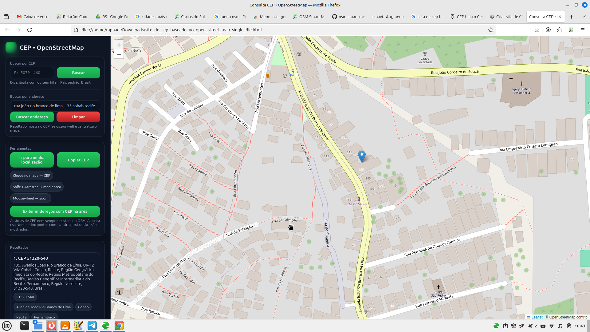
🌍 Sobre o Projeto GeoCEP
O GeoCEP nasce como uma iniciativa voltada para a comunidade, com o objetivo de facilitar a busca e visualização de CEPs e endereços a partir de dados livres do OpenStreetMap (OSM).
O projeto reforça a importância da colaboração aberta, já que toda a base utilizada vem do esforço coletivo de milhares de mapeadores voluntários que contribuem diariamente para melhorar a qualidade da informação geográfica.
O aplicativo foi pensado para ser simples, acessível e inclusivo, servindo não apenas aos membros da comunidade OpenStreetMap, mas também a alunos, professores, pesquisadores e cidadãos em geral que buscam uma ferramenta confiável, educativa e livre para explorar os dados de endereços no Brasil.
I once walked past a small building, spotted that it’s got an address, and added it to OSM. Then I walked past it again, the building had its facade updated–and the address was nowhere to be seen.
We map a lot of ‘virtual’ objects in OpenStreetMap, boundaries and routes, but even addresses, the holy grail of survey, often end up virtual.
Take osm.org/way/1173366729: there isn’t an address on the building’s facade, yet 2GIS and Yandex.Maps have one.
Is there a private data agreement between the government and map services? 2GIS had some kind of city district polygons (elections related?) that someone even gave a review to asking what they were, and the Ministry of Information and/or of Digital Development already love giving out personal data of citizens to random software companies and banks in the name of ‘digitization’ (my bank’s app has everyone’s status with the police inspectorate and the psychoneurological dispensary and boldly let you see your own!), so it’s very likely.
P.S. The first building is on the cadastre, but there’s no building number, and the latter isn’t even on there at all :/ And don’t even ask whether one may copy from there.
I have noticed that the Apple mapping team, in their work within Kazakhstan, consistently mismapped various highway=* ways, for example:
- Mistagging of courtyard highways from highway=service to highway=residential.[2]
- Retagging of a highway=footway to a highway=residential, seemingly without any on-the-ground knowledge.[3][4]
- Various other bizarre additions or edits to service highways (also often mistagged), that I sometimes corrected or rolled back.[5]
If the Apple team does not have familiarity with how the highway tags are applied in a country[6] (a country here with a small OpenStreetMap community at that), or the specifics of urban development that span half the continent, then they, simply, should not map, and definitely not make the state of the map ever so slightly worse.
- [1] Betteridge’s law of headlines applies…
- [2] osm.org/way/458088367
- [3] osm.org/way/458088370 (both from the changeset 161673895)
- [4] Truly it isn’t a footway, as seen on Google Streetview, but may have been impassable for cars in the past!
- [5] Here, based entirely on my subjective idea that if there isn’t a curve in the highway area, then the highway centerline shouldn’t curve: osm.org/way/1192930242
- [6] There aren’t Kazakhstan-specific guidelines, but the Russian guidelines are applicable, where внутридворовые проезды (courtyard passages) are highway=service: osm.wiki/RU:Highway_classification
P.S. If anyone wants to fix the scary copy-pasted magically north-aligned square houses that were mapped all across the country, which previously, in part, made me register an alternative account and instead map pointless foreign stuff you’re welcome :P
Posted by Raquel Dezidério Souto on 26 August 2025 in English.
UMAP OF THE ATTENDEES CITIES - III WORKSHOP ON PARTICIPATORY MAPPING AND SOCIAL CARTOGRAPHY - MPCS 2025
– Portuguese below
We would like to thank the 462 participants from 151 cities in eight countries for taking part of our event!
Tomorrow, August 27th, 2025, at 2 p.m. (UTC-3), the program of lectures, mapping workshop with OpenStreetMap, mapathon, and the release of the book Case studies in collaborative and participatory mapping (book in portuguese).
Information and registration on the portal:
https://eventyay.com/e/b4950013
Follow the entire program 100% ONLINE and LIVE on the Virtual Institute for Sustainable Development channel - IVIDES.org on YouTube:
https://www.youtube.com/@IVIDES
Event’s Chairwoman: Dr. Raquel Dezidério Souto (IVIDES and UFRJ, Brazil)
See the full map - Veja o mapa em tela cheia

Map Data (Dados do mapa) 2025 © OpenStreetMap Contributors. License.
A few bike lanes were added in the part of town I live in (yay!) and I’d like to add them.
However, I’ve mostly been using these apps to map things: * everydoor * map complete website * go map !! (rarely)
I cant find any way in map compete to add bike lanes – they added on the street, so effectively making the space for the cars narrower. Is there any simple way of going about and adding these types of lanes?
Thanks!
Posted by SafwatHalaby on 25 August 2025 in English.

I’d like to share a simple method I’ve devised to map unfamiliar areas outdoors. Suppose you’d like create a GPX track of a park under the following constraints:
- GPS data is inherently inaccurate, so you’d like to walk each path exactly twice to improve accuracy.
- You’d like to finish an the exact point you started.
- You’re in the field, so you want to keep things simple and not use something too complicated.
Since the diary does not allow posting GIFs, the full post is in the community forum.
Posted by Archit Rathod on 25 August 2025 in English.
Last updated on 31 August 2025.
🎉 GSoC 2025 Final: Temporary Road Closures Database and API
Google Summer of Code 2025 • OpenStreetMap Foundation • Archit Rathod
After 15 weeks of intensive development, I’m thrilled to announce the successful completion of my Google Summer of Code 2025 project: Temporary Road Closures Database and API for the OpenStreetMap Foundation! 🎯
🚀 Live Demo - Try It Now!
Frontend: https://closures.osm.ch/
Backend API: https://api.closures.osm.ch/
GitHub: https://github.com/Archit1706/temporary-road-closures
GSoC Project: summerofcode.withgoogle.com
🎯 Problem Solved
OSM provides excellent static map data, but temporary road closures (construction, accidents, events) aren’t captured quickly enough for navigation apps. This project creates an open platform where communities can report closures in real-time and navigation apps can calculate closure-aware routes.
✨ What We Built
Complete Backend System
- FastAPI + PostgreSQL + PostGIS - Production-ready API with 25+ endpoints
- OpenLR integration - Universal location referencing for cross-platform compatibility
- OAuth2 + JWT authentication - Secure user management with Google/GitHub login
- Advanced spatial queries - Bounding box searches, proximity filtering, route analysis
Modern Frontend Application
- Next.js 15 + TypeScript - Interactive web interface with mobile optimization
- Leaflet maps - Real-time closure visualization with OpenStreetMap tiles
- Multi-step reporting - Guided forms for accurate closure submission
- Demo mode - Full functionality without registration for immediate testing
Closure-Aware Routing Innovation
- Valhalla API integration - Calculate routes that avoid relevant closures
- Transportation filtering - Car, bicycle, and pedestrian-specific closure relevance
- Route comparison - Direct vs. closure-aware route analysis
- Real-time optimization - Live route calculation considering current conditions
🌟 Key Innovations
OpenLR Integration
24.08.25 Все добре 😑
‼️
.Tôi đang tham dự lễ cưới của một người bạn thuở bé
Posted by lquandqung99l3113 on 24 August 2025 in Vietnamese (Tiếng Việt).
