OpenStreetMap 로고 OpenStreetMap

LogicalViolinist의 일기

최근 일기 항목

Wikidata dans OpenStreetMap

LogicalViolinist님이 French (Français)로 2016년 11월 11일에 게시함.

Vue que ID et Mapbox poussent pour incorporer wikidata dans OSM, je pensais ceci serait le projet parfait pour les catographieurs qui n’ont rien à faire ou dans des moments plus tranquilles.

Le lien wikidata peut aider les dévelopeurs à obtenir des informations vitaux comme la population courrante, le maire, les drapeaux, code d’armes, etc. La liste continue. Il y a beaucoup d’information qui ne peut même pas être encoder dans OSM. Ceci simplifierais l’utilisation des données OSM pour des petits développeurs. Prendre comme exemple l’exemple de Mapbox: Mapbox Data rich map

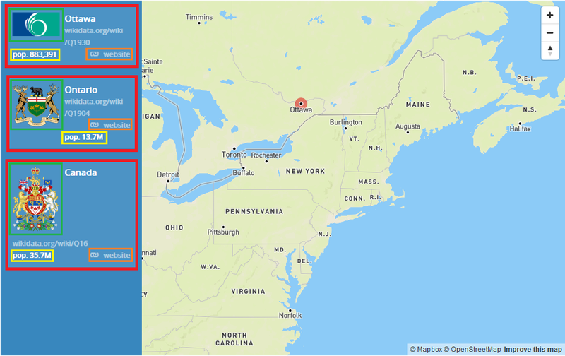
Les items dans le carré rouge ont tous été obtenu via l’api de wikidata en utilisant le champs wikidata (l’identificateur). Le drapeau dans le carré vert, la population en jaune et le site web en orange ont tous été capté à l’aide d’un champs d’identification

모든 항목 보기

위치: Hull, Gatineau, Outaouais, Québec, Canada

Wikidata in OpenStreetMap

LogicalViolinist님이 English로 2016년 11월 11일에 게시함.

Seeing as ID and Mapbox are pushing to incorporate wikidata into OSM, I thought it would be a perfect little project when mappers have nothing better to do or in their downtime.

The wikidata link can help developers get vital information like the current population, current mayor, flags, coat of arms,etc. The list goes on. This is a lot of data that can’t necessarily be encoded into OSM. This would help simplify the use of OSM data for small developers. Take for example mapbox’s example: Mapbox Data rich map

The items in the red square have all been obtained via the wikidata api using the wikidata ID. The flag in the green box, the population in the yellow, the website in the orange box.

모든 항목 보기

위치: Aylmer, Gatineau, Outaouais, Quebec, Canada