OpenStreetMap-ის ლოგო OpenStreetMap

Mapping Botswana-ის დღიური

Recent diary entries

Mapping Botswana report for November 2014

Posted by Mapping Botswana on 30 ნოემბერი 2014 in English.

November is at an end. The efforts of the Peace Corps make their mark on the map but many others have contributed to the map.

In December we hope to publish a tool to help show the mapping status of settlements. Stay tuned! Mapping Botswana in November 2014

Not a conclusive list of updated places:

  • Bobonong
  • Bokaa
  • Borolong
  • Borotsi
  • Chobe National Park
  • Dagwi
  • Deception
  • Diloro
  • Dobe
  • Francistown
  • Ghanzi
  • Gootau
  • Groote Laagte
  • Inalegolo
  • Kachikau
  • Kasane
  • Kazungula
  • Khawa
  • Kutamogree
  • Lecheng
  • Lesholoago
  • Lesoma
  • Mabalane
  • Mabuasehube
  • Mahalapye
  • Marobela
  • Maun
  • Mmadinare
  • Mochudi
  • Modipane
  • Moiyabana
  • Molalatau
  • Natale
  • Palapye
  • Pandamatenga
  • Pilikwe
  • Polenswa
  • Radisele
  • Ramokgonami
  • Robelela
  • Satau
  • Sefophe
  • Selebi-Phikwe
  • Shashe
  • Shashe-Mooke
  • Shoshong
  • Tati Siding
  • Thamaga Tlokweng Tobane Tutume

Mapping Botswana report for October 2014

Posted by Mapping Botswana on 31 ოქტომბერი 2014 in English.

The area between Gaborone and Mochudi is now very well covered with roads thanks to remote mapping using imagery, now we are missing more locals to add shops, schools and more.

The Peace Corps continue their fine work and are now using HOT to fight against malaria.

Edits in Botswana in October 2014

Nearly exhaustive list

  • Bokaa
  • Central Kalahari Game Reserve
  • D’kar
  • Damochojena
  • Kachikau
  • Kavimba
  • Kazungula
  • Kgari
  • Kuke
  • Lenyetse
  • Lesoma
  • Mabele
  • Majwaneng
  • Malotwana Siding
  • Maposa
  • Matebeleng
  • Maun
  • Mmadinare
  • Mochudi
  • Moremi Game Reserve
  • Morwa
  • Mosetse
  • Nata
  • Oodi
  • Palapye
  • Parakarungu
  • Pilane
  • Rasesa
  • Satau
  • Selebi Pikwe
  • Tutume

Mapping Botswana report for September 2014

Posted by Mapping Botswana on 30 სექტემბერი 2014 in English.

Mapping Botswana is fortunate to have acquired some new contributors in September, some local and some remote. Several Peace Corps volunteers have started to contribute from their assignments with Kachikau being a notable example.

The Protected Area Mappers keep up the good work with the vast Okavango Delta keeping them busy.

Locations of edits in Botswana September 2014

Nearly exhaustive list of places edited this month:

  • A3 road
  • Artisia
  • Dikgonnye
  • Dikwididi
  • Francistown
  • Ghanzi
  • Gumare
  • Gweta
  • Kazungula
  • Kgomodiatshaba
  • Khurutshe
  • Kokotsha
  • Leshibitse
  • Mabalane
  • Malolwane
  • Manxotae
  • Manyana
  • Mmathubudukwane
  • Modipane
  • Mogonye
  • Nata Lodge
  • Okavango Delta
  • Oliphants Drift
  • Oodi
  • Pandamatenga
  • Ramonaka
  • Ramotlabaki
  • Semboyo
  • Semitwe
  • Sikwane
  • Sowa Pan
  • Takatokwane
  • Thamalakane River Lodge
  • Tonota
  • Tswapong Hills
  • Zoroga
მდებარეობა: Kachikau, Chobe District, Botswana

Mapping Botswana report for August 2014

Posted by Mapping Botswana on 31 აგვისტო 2014 in English.

August 2014 was a busy month, we unveiled our Mapping Botswana website officially on August 12th, the 10th birthday of OpenStreetMap, and several new contributors joined the cause.

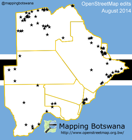
The map below shows the nearly 70 locations, some large and some small, that were updated during the month.

Locations of edits in Botswana August 2014

Nearly exhaustive list:

See full entry

მდებარეობა: North-West District, Botswana