Royal Roads University - Hatley Park - National Historic Site
Publeyêe per acrosscanadatrails lo 17 May 2010 en English.So i got tired of remote mapping all over the country, and decided to go on a little adventure to actually see this place.
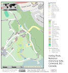 |
| From Royal Roads University grounds - Hatley Park - National Historical Site |
I made a cool tourist map
 |
| From Royal Roads University grounds - Hatley Park - National Historical Site |
And a key Map
Here you can see the photo album, (i also made a few videos in the set, explaining how to map)
http://picasaweb.google.com/samvekemans/RoyalRoadsUniversityGroundsHatleyParkNationalHistoricalSite?feat=directlink
There is still a few things todo, not sure where the best place to store the OpenOffice Draw file for that tourist map is. Any ideas?
Thanks,
Sam
Discussion