
Jornau de fidelcastrogis
Intradas recentas de jornau :

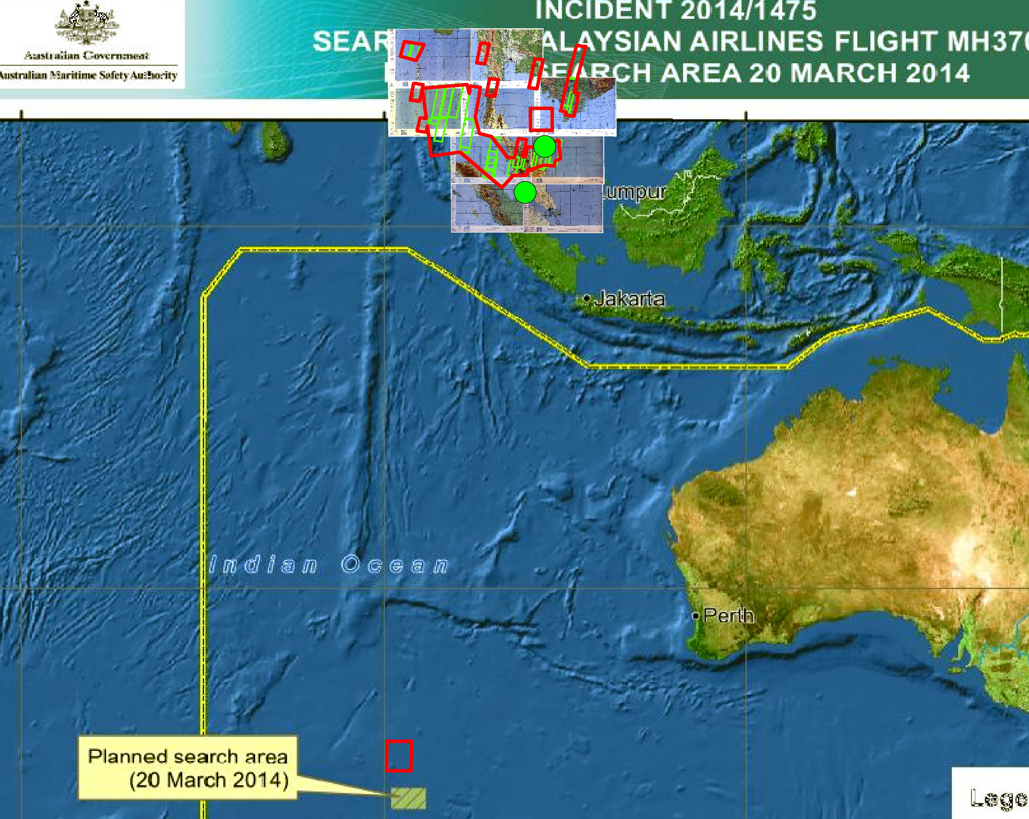
Any updated geospatial data from governments about MH370?
Postat per fidelcastrogis a 20 de març 2014 en EnglishAny sources or links?
Thanks, Fidel


Saudi Arabia (Jeddah), Colombia, Belize, FAA, and United States GIS and Shapefile Data
Postat per fidelcastrogis a 15 de febrièr 2014 en EnglishPublic Domain Boundaries Pakistan, Rwanda, and Haiti
Postat per fidelcastrogis a 8 de febrièr 2014 en EnglishPeru, Argentina, Chile, and India Boundary Shapefiles
Postat per fidelcastrogis a 1 de febrièr 2014 en English
Indonesia Shapefile Boundaries (Province, Regency, and Village)
Postat per fidelcastrogis a 25 de genièr 2014 en English
India, China, Honduras, and El Salvador GIS Admin Shapefiles
Postat per fidelcastrogis a 18 de genièr 2014 en English
New administrative boundaries Thailand, Uruguay, Nepal
Postat per fidelcastrogis a 11 de genièr 2014 en English
New administrative boundaries Tanzania, Ivory Coast, and Slovenia
Postat per fidelcastrogis a 4 de genièr 2014 en EnglishOpen data from 2004 or before, shapefile format: http://revolutionarygis.wordpress.com/2013/12/26/municipios-de-nicaragua-shapefile/
Hello! I am working on a few boundaries in China. I recently finished Deqing County, Huzhou. The data is in shapefile format here: http://revolutionarygis.wordpress.com/2013/12/20/deqing-county-huzhou-city-zhejiang-province-china-shapefile/
Are there any contributors in China who know where to find vector data? Also, can maps that the government publishes be used?
Fidel
China
Postat per fidelcastrogis a 20 de decembre 2013 en English Darriera actualizacion de 21 de decembre 2013Does anyone know where to find good open data for China? Can I make maps from official government documents?
I’ve obtained a government document from La Oficina Nacional de Estadísticas. I converted the pdf to a shapefile here: http://revolutionarygis.wordpress.com/
If you want other gis let me know. I am working on Nicaragua, India, and a few other places.
Fidel