Lògo d'OpenStreetMap OpenStreetMap

Jornau de ke9tv

Intradas recentas de jornau :

At long last, I’ve done a complete pass over municipal and CDP boundaries in New York State. Barring errors and omissions (I daresay there must be some) every incorporated community and every CDP in the state has had its border checked against NYSGIS Civil Division Boundaries and TIGER/Line 2021 respectively, almost always resolving conflicts in favour of the former. All have place=* nodes representing them, with the node a label member of the boundary relation.

Populations are updated as of the 2020 Census. GNIS, FIPS, NYS SWIS, Wikipedia and Wikidata links are provided.

Most of the remaining work that I’d have to do before I consider the job to be done has to do with the tagging on the place=* nodes. Right now, they’re a hodgepodge. Most of them came in from the TIGER import of 2008 with place=* representing their form of government. This is NOT an indication of the significance of the place. Brentwood, Long Island, a bustling community of over 60,000 souls, is tagged place=hamlet because it does not have home rule. Geneva, a sleepy lakefront village is 3400 inhabitants or so, is tagged place=city because it has a city charter.

For a first stratification, I’d propose simple thresholding on population:

See full entry

Use of New York State GIS data

Postat per ke9tv a 20 de julhet 2020 en English

(Disclaimer: I am not a lawyer, and none of this is intended to be legal advice. I do, nevertheless, consider myself to be an informed layman - and offer this analysis as a starting point for research into the legal status of GIS data in New York, with citations to relevant law, court cases, and commentaries from both sides of some of the controversies. I do not purport it to be an unbiased analysis; as and OSM contributor and otherwise as an ‘open sourcerer’, I have strong personal opinions regarding the purported ownership of factual information. I nevertheless attempt to present the law as it stands, even if I sometimes make the Dickensian observation that “the law is an ass.”)

What’s up with GIS data in New York?

GIS data originating from government agencies have, for about twenty years, been subject to considerably uncertainty and risk. This largely stems from the fact that in many jurisdictions, the mantra that “government should be run like a business” has led to expectations that state and local GIS departments should support themselves on user fees, rather than from the general fund. The most lucrative source of these fees has been the “multiple listing services” used by real estate agents to exchange data about houses on the market. These services often pay handsomely, far in excess of the cost of reproduction, for the maps of tax parcels. These provide the agents with the boundaries of properties listed for sale.

It is worth noting that in this discussion, I refer to State and local data. It has always been held that works prepared for the US Government by a government employee engaged in the performance of official duties are in the public domain. Works produced by contractors, depending on the terms of the contract, may be protected by copyright. Ordinarily, in this case, the copyright holder will be identified prominently. Those who use public data promulgated by a Federal agency have little to fear.

See full entry

A town line in the Catskills

Postat per ke9tv a 6 de decembre 2019 en English

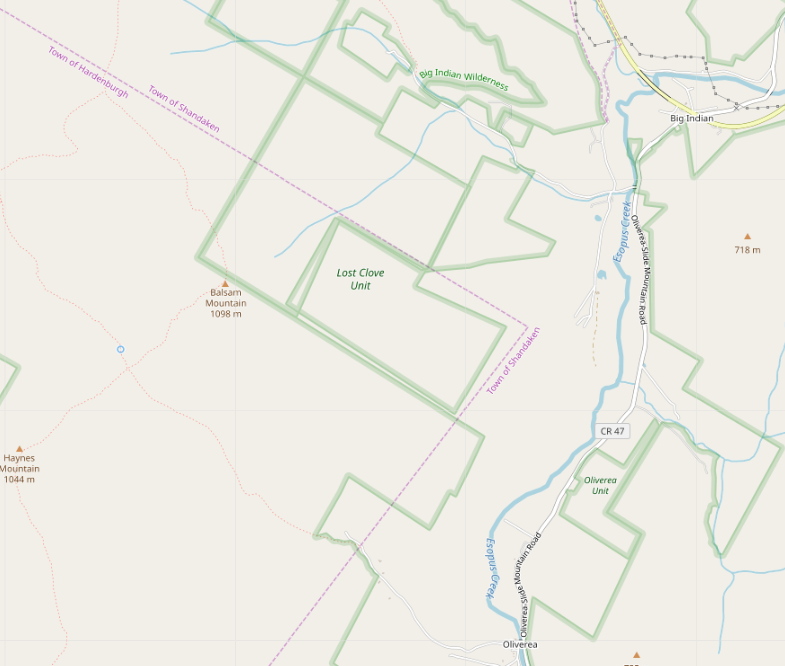
This post is intended to provide (rather too much) detail into my thinking as I attempt to synthesize several conflicting data sources into a ‘best guess’ drawing of an indefinite border between two townships in the Catskill Mountains of New York.

Our story begins when I noticed, while doing an import, that the Lost Clove Unit of New York City’s watershed recreation lands was badly misaligned with neighbouring parcels of state wilderness area, and that nothing seemed to join at right angles.

screenshot of the problem

See full entry

Luòc : Town of Shandaken, Ulster County, New York, United States

(US) State Parks: Searching for common ground

Postat per ke9tv a 13 de julhet 2019 en English Darriera actualizacion de 20 de julhet 2019

(US) State Parks: Searching for Common Ground

DRAFT FOR COMMENTS: Please do not treat as a formal proposal!

Introduction

For as long as I’ve been a participant on the OpenStreetMap project, the subject of what to tag a ‘State Park’ in the US has been fraught with controversy. (In some areas, there are equally controversial facilities named ‘county park’, ‘town park’ and so on with similar structure but administered by a still lower level of government.)

In this post, I try to find a common thread that can hopefully be used as a common foundation for all parties discussing the issue. Some of the specific examples given will be New York-centric. I apologize in advance for the fact. I am a native New Yorker, and I use examples with which I am familiar. I strongly prefer to map in places where I have boots on the ground - by which I usually mean literal boots on the literal ground. I have trodden the soil of all the places that I use as examples.

Proposal summary

State Parks should, as a ‘lowest common denominator’ be tagged with boundary=protected_area protect_class=21 (This combination would be the minimum necessary for rendering. Ordinarily, a state park would also have some combination such as protection_object=recreation protection_title="State Park"

Background

See full entry

The tagging of the Adirondack and Catskill Parks as boundary=national_park has been fraught with controversy. I’m more or less responsible for the tagging decision, and I’ve decided to make a diary entry explaining it, so that I don’t have to keep repeating the explanation.

These two entities are not ‘State Parks’ - unlike other parks such as Allegany State Park or Harriman State Park. In fact, they are unique entities in New York, and quite possibly the US and even the world.

Unlike most parks, which are created by statute, or even by executive proclamation, the Adirondack and Catskill Parks were created by a constitutional convention in New York, and are explicitly enshrined in article XIV of the state constitution, which begins:

The lands of the state, now owned or hereafter acquired, constituting the Forest Preserve as now fixed by law, shall be forever kept as wild forest lands. They shall not be leased, sold or exchanged, or be taken by any corporation, public or private, nor shall the timber thereon be sold, removed or destroyed.

This is the strongest protection enjoyed by any park or nature reserve of which I am aware. While all the others that I know about could be destroyed by a legislature’s passing a bill, any significant change to the Adirondack and Catskill Parks requires a constitutional amendment. There have been several such over the years, but none has come close to repeal. The most significant ones were the authorizations to construct the Olympic sports complex at Lake Placid, to build Interstate 87 through the Adirondacks, and to permit New York City to construct reservoirs and draw its water supply from the Catskills.

See full entry

Camp Smith, Peekskill, New York

Postat per ke9tv a 14 de decembre 2017 en English

I’ve been trying to get public land boundaries in New York State tidied to where trail maps will show reasonable results for the parks and forests.

One problem that was recently called to my attention was Camp Smith in Peekskill, New York. Researching this area revealed rather a complex history, and I thought that I had better write this diary entry to explain what I did, since it doesn’t quite agree with any of the ‘authoritative’ data sources.

Camp Smith, purchased by New York State between 1923 and 1940, is a National Guard post, and as such, is State land rather than Federal. The Hudson Highlands State Park that borders it is also, of course, State land, and in fact, portions along the north of Camp Smith had been carved out of it historically to create a corridor for the Appalachian Trail.

On that state land, a trail from the Bear Mountain Bridge to the summit of Anthony’s Nose has existed for a very long time. I know that I visited Anthony’s Nose as a Boy Scout in the late 1960’s. Since at least 1993, there has been a trail open to the public that takes a strenuous course from there southeast along the cliffs, with many fine view overlooking the river. Everyone understood it at the time to be a way along which public access was granted, that traversed the grounds of Camp Smith.

See full entry

New York Long Path

Postat per ke9tv a 2 de mai 2016 en English

I noticed that there were New York Long Path blazes when I went out a week ago (2016-04-24) to map the Wolf Creek Falls Preserve. (Actually, I knew in advance that they were there…) That made me remember that mapping the northern part of the Long Path ought to be a project. There are essentially no really good trail maps available of this trail from Huntersfield Mountain in the northern Catskills through the Schoharie Valley to its terminus (Thacher Park or Northville, according to whether you want to take it all the way to the Adirondacks). OSM has the opportunity to fix that.

I’ve started adding roadwalk and overlaid trails to the route relation, and posting notes for the missing sections. If nobody else does it, I’ll get out and GPS the missing sections at some point, but no real promise when that will happen.