Editing roads and rivers in Zamboanga City out of Bing imagery.
My personal aid/response to the victims of flooding in the City:
http://www.gmanews.tv/largevideo/regions/71828/flash-more-than-100-families-affected-by-flash-floods-in-zamboanga-city

Editing roads and rivers in Zamboanga City out of Bing imagery.
My personal aid/response to the victims of flooding in the City:
http://www.gmanews.tv/largevideo/regions/71828/flash-more-than-100-families-affected-by-flash-floods-in-zamboanga-city
Albay Province in the Philippines is in a state of calamity due to the continues rains the past few days [1]. Bing has some hires within selected towns [2].
I added a few stub road (highway:road) in Malilipot, Tabaco and Bacacay, hope this helps in improving the data. Rivers need to be mapped as well.
[1] http://www.gmanews.tv/story/209405/albay-under-state-of-calamity-due-to-landslides-floods
[2] osm.org/browse/way/87327595
Almost 3 years ago, we did a rough import of coastlines for the Philippines. The data came from the 90m pixelled SRTM converted to vector lines. Since this data came from a raster source, outlines appear jagged like a staircase, which we called as saw-tooth coasts.
The objective then is to provide a small-scale outline of the coasts and allow mappers to improve them (by using LANDSAT or PGS data). The problem persists to this day because, editing coastlines is too tedious and in some cases, dangerous.
In order to easily identify where the sawtooth problem occur, we created a simple webmap .
Large circles means more jagged steps.
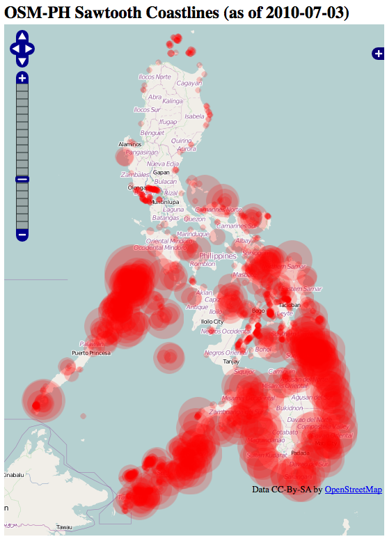
More mappers are needed to nuke the sawtooths. If anyone wants to help, see details here: osm.wiki/WikiProject_Philippines/Coastline_Corrections

In the next few hours (or minutes), we will have our 250k user signing-up. In our side of the patch (PH), we are getting more contributors as well. However, this comes with price. Very recently, we are seeing more "suspicious edits". As good OSM citizen we "politely" send them messages.
Some of these suspicious edits are then removed as soon as possible.
Just a few hours ago, someone sent me a message that on another mapping project, the user is copying OSM data. We have proven that the data indeed came from OSM. Thankfully, the maintainers quickly discarded these contributions.
As OSM becomes more of a force here in the Philippines, I foresee that we will be getting more of this kind of contributions. We can't monitor everything. We need more tools to monitor this behavior.
We are in the process of importing road and POI data in Bohol Philippines.
Details here:
osm.wiki/WikiProject_Philippines/Data_import_Arivac_Bohol#Attribution
And discussion here:
http://lists.openstreetmap.org/pipermail/talk-ph/2010-March/001951.html
Join the discussions if anyone wants to help.
I am currently improving road data along several towns of Rizal (Antipolo, Taytay, Angono, Binagonan, Cardona Baras, Tanay, Antipolo) using Yahoo!. Editing will end until I reach the edge of the imagery.
We will have our Openstreetmap Philippines Marikina City Mapping Party
on March 20, 2010.
Invite your friends. We will teach you how to map using GPS, paper,
on foot, car or bike. Let's make Marikina City the best mapped city
in OSM.
It's fun. It's free. You can help.
Please watch this page for more details:
osm.wiki/WikiProject_Philippines/Mapping_Party/Marikina
This came from the SPOT5 donated by Spot-Asia and Certeza Infosys last
year. Pixel resolution is around 10 meters date taken 2008-03-12.
Instructions on how to use in the wiki:
osm.wiki/WikiProject_Philippines/hires_imagery#Portions_of_Bulacan.2C_Pampanga_and_Nueva_Ecija
And my blog post here:
http://epsg4253.wordpress.com/2010/01/21/eastern-bulacan-pampanga-and-nueva-ecija-imagery-update-in-openstreetmap/
Enjoy!
I recently created a wikipage for the inventory of high-res images available for the Philippines [1]. I found out there's a lot of work we can do even without GPS.
Armchair mapping can be very handy to add road stubs and other details even if you don't know much of the area.
I found out recently a typical newbie behavior in the Philippines. Newbies usually don't touch white areas even if there is available high-res imagery. They usually correct something or add a few minor details that go out into the vast whitespaces.
Seeing the whitespots from my highres imagery inventory page, I started adding road along the Pampanga area [2] and will continue in the coming days. I hope newbies locals can fill in the details.
Anyone can also contribute, but for now, I encourage everyone to donate some mapping time to Haiti [3] and Albania [4].
[1] osm.wiki/WikiProject_Philippines/hires_imagery
[2] osm.org/browse/changeset/3647862
[3] osm.wiki/WikiProject_Haiti
[4] osm.org/user/h4ck3rm1k3/diary/9264
I suggest we focus tagging these features for Haiti Openstreetmap Response. Most of these features are visible in the GeoEye imagery.
- Roads
- Bridges
- Temporary campsites - tourism=campsite refugee=yes
- Damaged Buildings - building=collapsed
- Large open spaces to serve as relief operation centers
More info here:osm.wiki/WikiProject_Haiti#2010_Earthquake_Response
For the past years I am continuously editing Marikina City for roads, cycleways and footways. I believe OSM has the most "road complete" map of this City. However, I haven't really made a systematic approach or metric to say it is complete. You just have to take my word for it.
So for this year, I made a checklist of what to map and started logging all my activities in my wiki page: osm.wiki/User:Maning/Marikina
I hope in twelve months or less I can finally declare this patch as "complete" and move on to mapping (ugh!) house numbers.
I've been filling small gaps on my relatively "road complete" patch this holiday. Funny you can still find a few footways here and there.
So far I was able to:
- complete city administrative boundaries: osm.org/browse/relation/146949
- add a few POI along one of the major commercial strip: osm.org/?minlon=121.0926989&minlat=14.6223756&maxlon=121.0972386&maxlat=14.6359361&box=yes
- edited and merged several landuse boundaries
POI mapping is relatively easy on bike and a camera. You need to slow down a bit and try to balance one hand holding the gps (I don't mount the unit onto my bike because vibration for smoothness:horrible roads makes my trace wiggle unnecessarily) and the other holding the digital camera.
There is a little bit of personal bias with my preference on what POI to map. Others can of course fill in the gaps.
One question, on estimating the distance of POI from the road, I usually place it 5 -10 meters from the road centerline depending on how wide the roads are. Is this common practice?
I've been a member of this project for nearly 4 years. Today I finally traced and edited the very first GPS track I uploaded.
osm.org/user/maning/traces/1876
I have completely forgotten this trace because loading the java editor back then was painfully slow.
I have been tracing roads around Baguio City for the past weeks. The data came from some of my traces and high-res imagery. The tracing from high-res imagery were tagged as highway:road and a FIXME note.
By my rough estimate, this covers more than 50% of the roads already. However, most roads have no names and the appropriate highway type. Tracing can only go this far if local knowledge is limited.
The only way the data becomes useful (around this area) is when locals start adding and improving the data. Community is much more important than any data import.
Still, I hope my contributions would provide local mappers a good canvas to start adding the details.
I hope the data becomes useful by summer of 2010 when tourist start climbing this popular summer getaway.
Found this from a blog comment about OSM.
"I suggest that you should invite a mapping professional into your group. Mapping is not a kiddy thing. It requires knowledge on Geometric Geodesy and GPS Systematic Errors. Without the required knowledge, doing mapping is just like wearing a blindfold blindly."
http://mapping.ideacampdavao.com/2009/07/davao-mapping-party-post-party-report.html
newbie: I want to contribute to OSM
OSM "expert": Welcome! I suggest you start reading ASPRS journals on Geodesy and GPS geometric corrections.
newbie: OH OK, bye.
I am seeing a lot newbies adding POIs and streetnames around the Philippines lately.
Welcome guys/gals!
We have a lot of work to do :)
RULE NUMBER 1: HAVE FUN!
If you have questions, ask me. Or better, subscribe to the osm philippines mailing list:
http://lists.openstreetmap.org/listinfo/talk-ph
Our wikipage is here:
osm.wiki/WikiProject_Philippines
Keep on mapping!
found this while compiling node stats.
amenity:1 hectare commercial prop. for sale jun domingo 09228829926 1
amenity:1.1 ha. commercial property for sale 09228829926
www.adomingobrokerage.page.tl 1
amenity:2 storey building 213m2 for sale 1
amenity:2 storey building LA 210m2 for sale 09228829926 1
amenity:684m2 commercial lot for sale 09228829926 1
created by this user:
osm.org/user/jundomingo07/edits
Lately, I've gotten bored with my changeset comments. The usual comments like "add new POI at road X" or "edit X footway" doesn't tell much about how I feel during editing sessions. In order to spice them up, I'm adding more expressive comments on my changesets.
Some are here:
1. A requested edit of my daughter
osm.org/browse/changeset/1983558
2. A mouth watering POI edit
osm.org/browse/changeset/1873144
3. A frustrated edit
osm.org/browse/changeset/1737403
My post-party blog report on the our Fist OSM-PH Tagaytay Mapping Party:
http://epsg4253.wordpress.com/2009/05/21/post-party-report-tagaytay-osm-ph-mapping/