
How to tag a crossing waterway-highway
Zapsal sigon 26. 12. 2015 v jazyce English. Naposledy aktualizováno 27. 12. 2015There is a bridge
highway: secondary (or other)
layer: 1
bridge:yes
waterway:stream
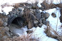
there is a culvert
highway: secondary (or other)
layer: -1
tunnel:culvert
waterway:stream
There is a ford
highway: road (or other)
ford: yes
waterway:stream
related tags
Bridge: artificial construction that spans a waterway, osm.wiki/Key:bridge
Layer: Used to mark the vertical relationship between two features, osm.wiki/Key:layer
Tunnel = culvert : culvert is a device used to channel water,
osm.wiki/Tag:tunnel%3Dculvert
Waterway = drain: channelised stream,
osm.wiki/Tag:waterway%3Ddrain

waterway= ditch Small man-made draining waterway,
osm.wiki/Tag:waterway%3Dditch

Ford: water flows over the highway
osm.wiki/Key:ford

Diskuse
Komentář od Warin61 z 26. 12. 2015 v 21:37
There is a Ford
Tag added to highway where water flows over the highway ford=yes
no layer tags as both highway and waterway are on the same level.
You have not sated above what the tags are added to. Suggest you edit?
Komentář od sigon z 27. 12. 2015 v 09:25
Thanks Warin61, edited :-)