
There is a bridge
highway: secondary (or other)
layer: 1
bridge:yes
waterway:stream
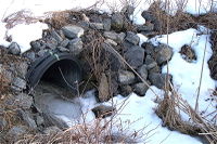
there is a culvert
highway: secondary (or other)
layer: -1
tunnel:culvert
waterway:stream
There is a ford
highway: road (or other)
ford: yes
waterway:stream
related tags
Bridge: artificial construction that spans a waterway, osm.wiki/Key:bridge
Layer: Used to mark the vertical relationship between two features, osm.wiki/Key:layer
Tunnel = culvert : culvert is a device used to channel water,
osm.wiki/Tag:tunnel%3Dculvert
Waterway = drain: channelised stream,
osm.wiki/Tag:waterway%3Ddrain

waterway= ditch Small man-made draining waterway,
osm.wiki/Tag:waterway%3Dditch

Ford: water flows over the highway
osm.wiki/Key:ford

討論
由Warin61於2015年12月26日21:37發表的評論
There is a Ford
Tag added to highway where water flows over the highway ford=yes
no layer tags as both highway and waterway are on the same level.
You have not sated above what the tags are added to. Suggest you edit?
由sigon於2015年12月27日09:25發表的評論
Thanks Warin61, edited :-)