How to tag a crossing waterway-highway
Käyttäjä sigon kirjoitti tämän 26. joulukuuta 2015 kielellä English. Päivitetty viimeksi 27. joulukuuta 2015.There is a bridge
highway: secondary (or other)
layer: 1
bridge:yes
waterway:stream
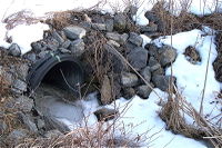
there is a culvert
highway: secondary (or other)
layer: -1
tunnel:culvert
waterway:stream
There is a ford
highway: road (or other)
ford: yes
waterway:stream
related tags
Bridge: artificial construction that spans a waterway, osm.wiki/Key:bridge
Layer: Used to mark the vertical relationship between two features, osm.wiki/Key:layer
Tunnel = culvert : culvert is a device used to channel water,
osm.wiki/Tag:tunnel%3Dculvert