شعار خريطة الشارع المفتوحة خريطة الشارع المفتوحة

يومية thbz

إدخالات يوميات حديثة

Deambule - random walk

نُشِر بواسطة thbz في 18 أغسطس 2018 باللغة English

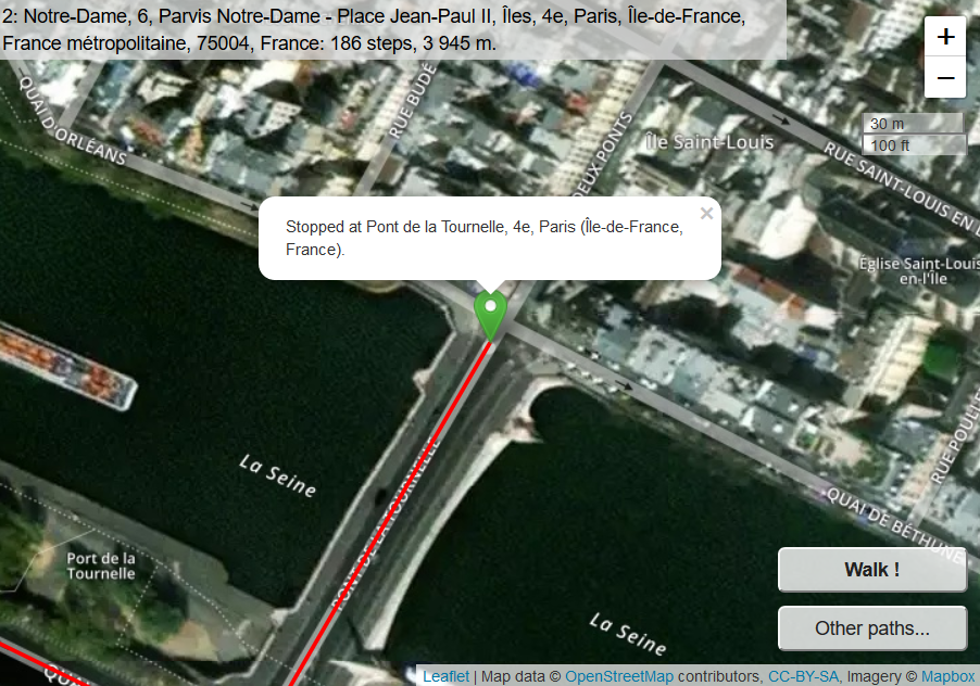
Have you ever wondered where you will get to if you walk at random in a city ? Will you go far away or simply wander around in your neighborhood? It’s a well-known mathematical problem, usually applied in my country to people who have drunk too much.

A few days ago I thought it might be fun to watch that drunkard walk on Openstreetmap. Some quick coding with Leaflet, Overpass, Nominatim, etc., produced something I called Deambule. Random path in Paris Every time you click on Walk, the drunkard, or let’s say the robot, walks 50 steps (where a step means going from one OSM node to the next OSM node on a way). At every corner it chooses one of the ways at random (trying to avoid directions he took very recently).
See full entry

Louvre indoor

نُشِر بواسطة thbz في 28 أبريل 2017 باللغة French (Français) آخر تحديث في 3 مايو 2017

Aujourd’hui j’ai terminé le Louvre. 1 035 objets indoor selon l’indispensable OpenLevelUp. Certains espaces ont été cartographiés avant moi par d’autres contributeurs (cour Puget, quelques salles égyptiennes). J’ai suivi la spécification Simple Indoor Tagging. Il ne manque que quelques salles fermées pour travaux, et tout ce que j’ai sûrement oublié ici ou là. Je vais donc faire un second passage pour vérifier chaque salle, chaque couloir, chaque entrée, et chaque attribut de chaque objet. Harmoniser la gestion des descriptions, des entrées. Rajouter sans doute des escaliers en ways parce que les areas, ce n’est pas suffisant pour un escalier. Indiquer peut-être les noms de départements.

Rien n’est simple au Louvre : escaliers de trois ou quatre marches avec un arrêt d’ascenseur en haut et un autre en bas, étages superposés mais jamais identiques, fiches descriptives de salles qui suivent des conventions différentes d’un département à l’autre, angles pas forcément droits, vestiges médiévaux, escaliers aux formes ingérables

Et puis il faudra peut-être se demander à quoi tout cela peut servir. Il y aurait de quoi faire un petit guide sur smartphone.

Subway stations in Seoul (2)

نُشِر بواسطة thbz في 5 أبريل 2015 باللغة English

So I did what I had planned in the previous diary and checked with some Overpass queries. For example, this query should probably produce no result.

Tests

Now, the following Overpass requests work:

  • Get the subway network in Seoul (lines 1 to 9) (see on a map):

      relation[route=subway][name~"^[1-9]"]({{bbox}});
      (._;>);
      out;
    
  • Get all stops on line 2 (see on a map or get the data)

      relation[route=subway][name~"^2"]({{bbox}});
      node(r:"stop");
      out;
    

Conclusions

I have 3 conclusions.

See full entry

Subway stations in Seoul

نُشِر بواسطة thbz في 3 أبريل 2015 باللغة French (Français) آخر تحديث في 3 مايو 2017

I have been working on the bus and subway routes in Seoul lately, but there are still many discrepancies and missing tags. So I thought I might try to do some planning instead of always improvising, une fois n’est pas coutume. And I’ll practice my English, too, and learn more about Markdown.

The references:

The rules :

  1. Work on subway lines 1 to 9. Whether other lines should be dealt the same way might be discussed later.

  2. Every existing railway=station node that corresponds to a subway station should also be tagged as public_transport=station, subway=yes and (if it’s only for lines 1 to 9) station=subway. Reciprocally, any public_transport=station should be tagged the same way if it corresponds to a subway station.

  3. Existing nodes should not be moved unless really necessary (i.e. do not apply the “This node should not be part of a railway track” rule for an existing railway=station node, unless I am ready to really map a public_transport=stop_area relation for that station).

  4. Only one railway=station node should exist for every subway station, unless it is used for very different networks (lines 1 to 9 will be considered as one single network, I may let several railway=station nodes if they exist in multi-network stations such as 서울역, but I’m not sure about that).

  5. Every existing public_transport=stop_position node in the subway network should be tagged as subway=yes and be located on a railway=rail or railway=subway way. It should not be tagged as railway=station or station=subway.

  6. All the public_transport=station nodes that belong to the same line should be members, with no role, of the relation(s) associated with that line. These relations may follow the new Public transport proposal (i.e one relation for each direction or branch) or not.

The planning:

See full entry

Mieux que le prolongement jusqu'à la mer du boulevard Saint-Michel

نُشِر بواسطة thbz في 29 سبتمبر 2012 باللغة French (Français)

Tout à l’heure j’ai remarqué sur openstreetmap.org une modeste rue du 13e arrondissement de Paris qui paraissait traverser des quartiers où elle n’avait en principe rien à faire. Impression fugitive, car rien n’apparaissait lorsque je passais en mode édition (Potlatch). Sans doute était-ce une erreur du moteur d’affichage.

Un peu plus tard j’ai découvert, sous JOSM, que cette rue s’étendait bien jusqu’aux limites de l’arrondissement, et même au-delà ; en fait, un zoom arrière montrait qu’elle s’incurvait peu à peu vers le nord, aussi bien à l’ouest qu’à l’est, jusqu’à former un cercle dont le sommet septentrional se trouvait… quelque part entre le Royaume-Uni et le Danemark.

Je ne maîtrise pas encore parfaitement OSM, mais il semble bien que ce soit [une fausse manipulation de ma part] (osm.org/browse/changeset/13293665) qui a ainsi projeté dans les eaux glaciales de la mer du Nord une petite rue résidentielle. Erreur corrigée à présent. Du moins je l’espère…

الموقع: Quartier de la Maison-Blanche, Paris 13e Arrondissement, Paris, France métropolitaine, 75013, France