OpenStreetMap логотибы OpenStreetMap

uroesch ҡулланыусының көндәлеге

Һуңғы көндәлек яҙмалары

OSMカストマイズTシャツ注文しました

Japanese (日本語) телендә uroesch 3 October 2010 баҫылып сыҡты.

最近忙しいからOSMに時間つくるのは難しくなってきました。シルバーウィークにとったTraceまだ編集してないし Mapping Partyのデータも処理できずとにかくOSMのことほったらかし。
今日はやっとちょっとだけ時間をつくれてインタネットでOSMのカストマイズTシャツをデーサインを注文した。来週届くらしいものすごくわくわくしてる!

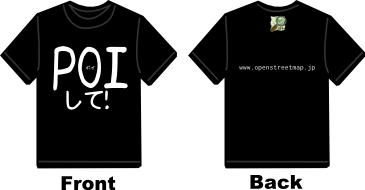
I have been busy with real life tasks and had very little time do OSM releated tasks ever since Silver Week. But today I had a bit of time on my hands and swiftly ordered my first ever custom made t-shirt. The design can be seen above. Looking forward to the deliver next week.

I was able to swap some hardware and get the system back from the dead.
The maps are once again available from http://verleihnix.bun.ch/gmap/asia/japan

この間死んでしまったサーバを復旧できました。毎日アプデートしたOSM地図はまだhttp://verleihnix.bun.ch/gmap/asia/japan でダウンロードできます。

In the news: Japan launches first GPS satellite

English телендә uroesch14 September 2010 баҫылып сыҡты.

There was already a post in Japanese about it so I wanted to post some information in English as well (although a bit late).

Over the weekend Japan launched its first ever GPS satellite that will help to get better accuracy in the concrete jungle of major cities and in the mountains.
From what I hear the service won't be available for mere mortals until 2013 tho.

For more information check out these news items.

BBC news article -> http://www.bbc.co.uk/news/world-asia-pacific-11273982
JAXA launch MICHIBIKI via HII-A launch vehicle -> http://www.nasaspaceflight.com/2010/09/jaxa-launch-michibiki-via-hii-a-launch-vehicle/
The official Michibiki site -> http://www.jaxa.jp/countdown/f18/index_e.html

Daily Japan garmin maps currently unavailable

English телендә uroesch13 September 2010 баҫылып сыҡты.

Yesterday the server crunching and processing the Japan Garmin images died unexpectedly. Fortunately it was not a harddisk crash but it seems the motherboard or at least the SATA chip have gone bad.

For the time being the maps are no longer available from server verleihnix.bun.ch and at this point in time I don't have an ETA when things will normalize.

I already put a note to the English and German Garmin download wiki pages to inform everyone of the issues.

OSC2010 Tokyo Fall

English телендә uroesch11 September 2010 баҫылып сыҡты.

I'm on my way back from OSC2010 Tokyo Fall (osm.wiki/OSC2010_Tokyo_Fall) at Meisei University where OSM had a small booth.

It was a blast! For the first time since I joined OSM I met fellow mappers in person. nori_u, higa4, Tom_G3X, Hiroshi Miura, ikiya and techstorm.

Go OSM Japan go!

Урын Hodokubo 2-chome, Hino, Tokyo, 191-0042, Japan

Mount Fuji

English телендә uroesch20 August 2010 баҫылып сыҡты.

I'm just about to emerge on my third hike up Mount Fuji and the second one with my GPS unit firmly in my hand :). Last year I took the Yoshida trail up and the Subashiri down. But this year I want ascend on the Gotemba trail and descent on the Fujinomiya one. Both not yet on the map.
I just hope no one else is having the same idea.

See this map for more information about the hiking trails:
http://www.pref.shizuoka.jp/kensetsu/ke-000/topics/images/mt_fuji100709.gif

Урын Fujinomiya, Shizuoka Prefecture, Japan

Onother short vacation in Kobe

English телендә uroesch14 June 2010 баҫылып сыҡты.

I seems that the weather is always in my favor when going to Kobe for a short vacation. Last time a month ago It was clear blue sky and lots of surveying on foot with the occasional taxi rides from the station to my in-laws' house.

This time around I had more bus rides than actual surveying on foot. So the progress in Kobe is more visible and not only concentrated to the Nagata-ku area around Nagata shrine. Unfortunately on the day of departure it was raining cats and dogs and I was not able to log the taxi ride back to Shinkobe station.

If everything works out I hope to go back again sometimes in August hopefully mapping a few mountain trails.

Урын Omichidori 4-chome, Nagata Ward, Kobe, Hyogo Prefecture, 653-0832, Japan

Golden Week vacation in Kobe

English телендә uroesch20 April 2010 баҫылып сыҡты.

I'm going to be in Kobe for Golden Week vacation (May 1 - 5) and wondered if there are other mappers in the area that want to meet up.

I'll be staying around the Nagata area which I probably will be making the playing ground for the time of the stay. If the weather holds I might even to a couple of tracks up one of the many mountains in close proximity.

Kobe surely deserves better than the current state and needs some mapping love :).

Урын Nibancho 2-chome, Nagata Ward, Kobe, Hyogo Prefecture, 652-0803, Japan

Daily garmin gmapsupp.img of Japan

English телендә uroesch22 February 2010 баҫылып сыҡты.

Last week the weather here in Japan was seriously bad with rain and snow for a few days so I had to take a small break from surveying my home turf.

That said I spent some time kicking the bucket with osmosis and mkgmap. It took me a bit of mucking around to get everything working on my wimpy P4. But after a few hours of processing the files are finally available.

Since everything is running of my home DSL I put some bandwidth limitation on the downloads and speeds should not reach more than 20kbit/s for any download. Please only download if you really need the maps. There is limited bandwidth on that link.

At this point the maps are still considered beta, while I have used them myself I don't know if they are any good outside of Tokyo.

If you find any issues let me know.

OSM files: http://verleihnix.bun.ch/osm/asia/japan
GMAP files: http://verleihnix.bun.ch/gmap/asia/japan

Happy downloading :)

cheers,

--urs

My vacation mapping project is coming to an end

English телендә uroesch 4 August 2009 баҫылып сыҡты.

As my vacation is coming to an end and I have to fly back to Japan I have nearly finished Koblenz in Switzerland.

Within the last 3 weeks it went from a blackhole to nearly complete save for some really pathes along the Rhine and a few tracks here and there. I do think I have the probably all the paved roads and names of the streets completely recorded.

When arriving on last month I thought I would finish the whole thing very quickly but as I went out with my GPS unit I found so many tracks I thought it never ends.

Урын Horeb, Koblenz, Bezirk Zurzach, Aargau, 5322, Switzerland