OpenStreetMap logo OpenStreetMap

Users' Diaries

Recent diary entries

Quer aprender a mapear as edificações, após a ocorrência de um desastre? Conheça a metodologia BAR, aplicada ao mapeamento com OpenStreetMap e JOSM


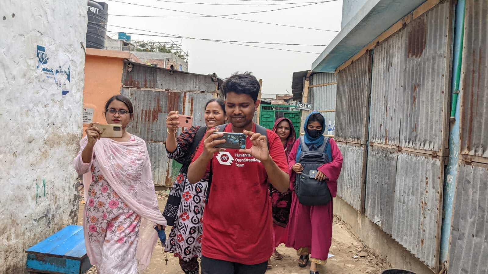
Em 19 de maio de 2025, realizamos com sucesso a oficina Mapeamento pós-desastre com OpenStreetMap e JOSM, promovida pela empresa IVIDES DATA e o grupo de jovens mapeadores(as) brasileiros(as), YouthMappers UFRJ, e ministrada por Séverin Ménard, do Les Libres Géographes.

Read in English

IMG VIDEO 1


As recomendações e vídeos de demonstração estão também disponíveis na seção de orientações dos projetos de Mayotte no HOTOSM-TM.

See full entry

Today, Monday 19th May 2025, Made me one week at my IT, And so far i can say it has been great for me, Topping the chart, mapping over Thousands of building just in one week. Yes i sign up for this, that’s why I’m here to lead and take the topflight. Saying about today, I got the opportunity to teach and lecture one of my new IT College on what OpenStreetMap Is, His name is Alex though, And it was fun throughout the whole process. For fact, i know a lot is gonna come my way through this program, which I’m waiting for it and ready for success!!!

Location: Rumuosi, Obio/Akpor, Rivers State, 500004, Nigeria
Posted by OG Alex on 19 May 2025 in English.

So today i learned what is mapping and how to map and i mapped some building. it was a beautiful experience and i really enjoyed it. i met a guy called fortune he taught me almost everything i learned about mapping he is and easygoing guy, i still met a lot of fun people that will make learning easy. When i started i first learned what is mapping the site used for mapping which was later introduced as OSM US tasking manager. after that i created my account did my first mapping under the supervision of fortune and when he checked what i did and approved it i continued with some project he gave me and i finished 2 mapped task.

An open, cross cutting feature request for streetcomplete, everydoor, organicmaps and anyone else who targets mobile data capture.

  • Ask for location detection (yup), device activity sensors (maybe not already asked for)
  • If I am detected in the same place and that place has a shop=* or amenity=* for 5-15 minutes
  • Activity detected is “still” or similar (I put my phone down, or walked around a shop)
  • Can I please get a nuanced prompt at some point either then or within a few hours?
  • And limit current notifications to 1

Particularly for cafes, restaurants, pubs, etc.

Why: Google maps does this for reviews, to great effect. Ask me, while I am at a restaurant, with a physical menu “Is the cuisine vegetarian?” Or “what’s the website?” (Often printed on menus) Ask me, while I am a cafe, “is there outdoor seating?”

The problem this solves is often I don’t know when a favourite place is missing data. I go there all of the time, why wouldn’t it be mapped?

Give me a “no thanks” option so if I don’t want the intrusion I can opt out easily. But if I hit “yes please, nudge me”…

Following various discussions and requests over the previous years, I’ve adapted parsing of the machine-readable osmc:symbol tag in waymarkedtrails for route symbols to cover more use cases. The new implementation comes a bit closer to what is specified on the wiki website, most notably now supporting a second foreground, but also extending the list of supported backgrounds. This posts gives a bit of background on the changes.

Supported syntax

The official specification of the osmc:symbol tag always had the issue that it largely relies on guessing the function of its parts from their content. A part called red_bar? Must be a foreground description because there is no “bar” background and the content looks to be too long to be a text description, too. This is a viable way of describing something but not very robust against typos and it makes it very hard to extend the value set. waymarkedtrails has therefore implemented a subset of the specification that could be parsed in a way that the function is determined from the position of the parts. This subset was essentially: waycolor[:background[:foreground[:text[:textcolor]]]] Unfortunately this approach made it impossible to support the second foreground when it popped up on the wiki page and that has left users confused ever since.

User mueschel has recently re-analised the format and came to the conclusion that we can still keep the positional approach when sticking to the following combinations of part descriptions:

waycolor:background waycolor:background:foreground waycolor:background:foreground:foreground2 waycolor:background:foreground:text:textcolor waycolor:background:foreground:foreground2:text:textcolor

The one officially allowed variant that isn’t covered is waycolor:background:text:textcolor. Luckily this variant isn’t really used in practice with very minor exceptions. And it can easily be made compliant by adding an empty foreground: waycolor:background::text:textcolor.

See full entry

Hello fellow mappers, I’m Ezekiel Kiariro, a passionate GIS and remote sensing expert based in Tanzania, and I’m truly honored to be nominated as a 2025 Voting Member of the Humanitarian OpenStreetMap Team (HOT). I’ve been mapping since 2020, and what began as curiosity quickly turned into a calling. Today, I serve as the GIS & Open Mapping Manager at GeoTE Tanzania, where I lead and support various community-based mapping initiatives across the country. I’m excited to share a bit more about myself, what HOT means to me, and how I hope to contribute as a voting member.

What Does HOT Mean to Me?

To me, HOT is a movement that embodies equity, collaboration, and action. It’s about creating open, accessible geospatial data to solve real-life problems, especially in vulnerable and underserved areas. HOT represents a community where people from different backgrounds use open mapping as a tool for change, resilience, and empowerment.

How I Got Involved in HOT and Mapping

My journey started through Youth Mappers and university training sessions in Tanzania. Inspired by the potential of OpenStreetMap to support humanitarian response and planning, I became an active mapper, trainer, and later a national organizer. Since then, I’ve:

  • Organized local and national mapathons and Open Data Day events
  • Supported field data collection using OSM-based tools
  • Co-led the GeoTE-Tanzania Field Training Program, a five-week initiative to integrate OSM into university curricula
  • Mentored young mappers and helped local communities map their own spaces, such as informal settlements and health risks From mapping roads and buildings in disaster-prone areas to leading sessions on NDVI and land cover classification using OSM-integrated datasets, I’ve seen how open mapping directly contributes to decision-making, planning, and community resilience.

Why I Want to Be a Voting Member

Being a voting member gives me the chance to:

See full entry

Location: Madizini, Morogoro Municipal, Morogoro Region, Coastal Zone, 67104, Tanzania
Posted by rphyrin on 18 May 2025 in English.

Although I read the newspaper (almost) every day, lately I’ve been getting news faster through my social circle. It usually starts as a rumor from an online friend, popping up on my timeline :

“There’s a new bus route coming to town!”

“Look at this photo I took— they’re testing the route!”

“I tried the trial run. Here’s a draft of the route I recorded myself.”

That’s what I’d been hearing for the past few weeks.

And then, finally, that rumors showed up in the daily newspaper I read.

See full entry

I am honored and humbled to introduce myself as one of the nominees for the 2025 Humanitarian OpenStreetMap Team (HOT) Voting Membership.

My name is Adamu Muhammad Adamu, a geographer, mapping advocate, and dedicated leader from Gombe State, Nigeria. I currently serve as the President of the National Association of Geography Students (NAGS) at Gombe State University, where I also lead our active YouthMappers chapter—a platform that has significantly shaped my journey into open mapping, humanitarian work, and global collaboration.

  • What HOT Means to Me

HOT represents more than an organization—it is a movement that embodies inclusion, empowerment, and action.

To me, HOT stands at the intersection of technology and humanity, where data becomes a tool to respond to crises, build resilience, and bring visibility to marginalized communities. It is through HOT that young people like myself have found a purpose in contributing to real-world solutions, bridging the gap between global challenges and local realities.

  • My Journey into Mapping and HOT

My engagement with HOT began in 2020 through YouthMappers. What started as curiosity evolved into a passion and a responsibility to serve. I joined mapping campaigns, led training sessions, and participated in field data collection. In time, I became a mentor and mobilizer, encouraging others to see maps not just as tools, but as voices for the voiceless.

In 2024, I was proudly selected as a Leadership Fellow to represent my country in Bangkok, Thailand, and now selected as a Volunteer Regional Ambassador for YouthMappers in Nigeria, a role through which I support chapters across the country, encourage inter-campus collaboration, and promote open mapping as a vehicle for humanitarian and sustainable development.

  • Selected Projects and Community Impact
  1. Kwakwambe Village Mapathon – Adamawa State.

See full entry

Posted by elisa44 on 18 May 2025 in French (Français).

Comme les vitesses max sur les ter Ste-Pazanne -> Pornic / St-Gilles sur Open Railway Map étaient totalement fausses, avec du 80 voire du 60 de St-Hilaire jusqu’à Pornic, j’ai cherché et trouvé des cabrides de conducteurs qui affichaient les vraies vitesses de ligne. Voici donc ces lignes enfin correctement cartographiées. Merci aux ADC qui font des cabrides, et vive le pays de Retz :)

Location: Cheviré - Zone portuaire, Bellevue - Chantenay - Sainte-Anne, Nantes, Loire-Atlantique, Pays de la Loire, France métropolitaine, France

Brazil Singh on a Field Mapping, Supporting HOT & Open Mapping Hub's Dhaka Thrive Project in Bangladesh

Hello OpenStreetMap and HOT Community,

I’m Brazil Singh, from Bangladesh, and I’m honored to be nominated as a 2025 Voting Member of the Humanitarian OpenStreetMap Team (HOT). I want to take this opportunity to share my story, what HOT means to me, and how I hope to contribute as a voting member.

I currently serve as an Open Mapping Guru at the Asia Pacific Hub and as a Regional Ambassador of YouthMappers. Through these roles, I’ve been able to support my community and contribute to open mapping efforts across the region. I’m also actively involved with the OpenStreetMap Foundation’s Communications Working Group, where I help strengthen global community engagement and communications.


What HOT means to me

See full entry

Location: Elenbari, Tejgaon, Dhaka, Dhaka Metropolitan, Dhaka District, Dhaka Division, 1215, Bangladesh
Posted by cybermapper on 18 May 2025 in English.

I will stop editing here after more than year of contribution because of various reasons, mainly political reasons.

I feel like continuing to support the project which is politically involved in mapping scope is not my moral thing to do anymore.

OSM’s ridiculous policy about who controls the ground, those determine the border is far more ridiculous than occupation itself. I am not surprised that these people do not understand what is international recognition means. The policy of “who controls the ground” is simply supporting any “invasion / annexation / or whatever term here” and running away from the reality of internationally recognized borders. If OSM is run by Europeans or Americans or Russians (who support their invasions and military presence in Moldova, Ukraine and Georgia) I am not remotely shocked. Because if they understood, world would not have been this trash since WW2.

I have seen it first time when I was removing fake Armenian names from the Karabakh area (was under occupation in between 1992 and 2024), DWG contacted me about not removing them because they have talked to Armenians who felt nostalgically bad about those. I was in utter shock for an American in DWG who did not think about occupation a second, but being fully biased on occupiers side asking how they would feel.

The same goes to Russo-Ukrainian war, for some reason they show Donbas as Ukraine area while it is under occupation, but showing Crimea not as a part of Ukraine while it is under annexation and occupation.

Same situation is with Georgian occupied areas.

I am familiar with double standards of Europeans, so no surprise here at all. You guys can enjoy mapping with disputed areas and changing borders every day.

Good luck to you all!

Posted by MugerwaHukasha on 17 May 2025 in English.

I’m a skilled cartographer and GIS professional with expertise in mapping, spatial analysis, and information visualization using various software, including ArcGIS, QGIS, AutoCAD, ACAD, and OpenStreetMap. I create informative maps, conduct network analysis, and perform connectivity studies to drive insights and inform decision-making, leveraging my skills in GIS mapping, spatial analysis, and cartography to deliver high-quality solutions and contribute to projects that require spatial analysis, mapping, and data visualization.

Location: Nsooba, Kawempe, Kampala, Central Region, Uganda

Gis

Posted by MugerwaHukasha on 17 May 2025 in English.

Cartographers in Uganda’s National Water and Sewerage Corporation would play a vital role in water resource management by creating maps of water infrastructure, such as pipes and treatment plants, and mapping water sources like rivers and lakes. They would also identify areas prone to flooding, monitor water quality, and inform infrastructure planning using geospatial data. By providing accurate spatial data, cartographers would enhance planning, efficiency, and decision-making, working closely with engineers, hydrologists, and environmental scientists to ensure effective water resource management and infrastructure development.

//孤江逝蓬屿,九川归海闾。 //童时向大地涂鸦,亲切与问候,河滩与玩耍。 //涛推沫积岸,潭映空城虚。 //向着变小的公园走去,着梦的领巾染亮了池。 //枷手绘淮渎,禹步测太行。 //望着从未去过的大洋,想象着地球的另端。 //正影求地中,过洋伴牵星。 //歪斜的铅笔勾画着地图,摇晃的单车追逐着积云。 //无当朝碧海,也未暮苍梧。 //独自狭目换从近地轨道俯瞰,精确的点值代替畸变的步量。 //世界映射于所见之内,地史编译自双手之间。 //纵握星月,把使地国。 //只不过, //宽阔的巷宇与屹立的厦尖缩小着, //直到足以被一个坐标系全然考量。 //包括那本早已黄霉的地图册。 注:本诗存在诸多可借读意象,但不存在任何对于平台及贡献者等组织势力的评价,仅作为个人文学作品,请理性看待。

Posted by AngocA on 17 May 2025 in Spanish (Español). Last updated on 27 May 2025.

Cuando se usa Google Maps, realmente se está accediendo a un conjunto de herramientas y características que se ofrecen ahí. No es solo el mapa base, por lo tanto la comparación con OSM no puede ser de solo el mapa base sino de todas las funcionalidades.

Aquí muestro una comparación de servicios dentro de la plataforma Google Maps, y el conjunto de opciones equivalentes en el ecosistema de OpenStreetMap.

Es una lista en crecimiento, por lo que quedo atento a los comentarios para complementarla.

Google OSM
Maps OpenStreetMap-visualización + Mapnik-renderizado + CartoCSS-estilo
StreetView, Panoramio Mapillary, Mapilio, KartaView, Panoramax
Aplicación móvil y mapas offline OsmAnd, Maps.me, https://organicmaps.app/, Locus Map, muchas otras
My maps uMap
Map Maker iD, JOSM
3D buildings F4 demo, Streets gl
Indoor maps indoor equal, OpenlLevelUp
Route Planner OpenTripPlanner, Valhala, GraphHopper, OSRM
Bird’s eye OpenAerialMap, hay datos aquí, aunque no es equivalente
Local guides OSM Mappers, communities
Ranking, contribuciones OSM stats
Reviews ORA, lib.reviews, aunque no son proyectos muy desarrollados
Servicio de Teselas (Tile services) Mapbox, OpenMapTiles, otros
API Leaflet, OpenLayers, MapLibre GL JS
Geocoding - address Nominatim
Buscador Overpass, Sophox, Postpass
  • Satelite - No libre, pero se puede acceder a las de Microsoft Bing, Esri.
  • Aerial View - No hay opción
  • 45º imagery - No hay opción
  • Immersive View - No hay opción
  • Real time traffic - No hay opción libre, http://mapbox.com/traffic-data
  • Weather - No hay opción
  • Lens in Maps - No hay opción

See full entry

Posted by rphyrin on 17 May 2025 in English.

May 16, 2025 (22.46 PM) : “Before starting validation on Project 18915, would you mind assisting with validation on another project first? It would be helpful for practice on a few tasks/grids beforehand.”


Since this is my very first validation project, I thought it would be best to train myself beforehand.

To start, I needed to choose a project to validate. I preferred a recent and active one, so I decided on Project #20468, which was created in response to the recent earthquake in Myanmar. The objective of this mapping project is to identify clusters of residential areas to support better disaster mitigation efforts in the future. Individual buildings do not need to be mapped—only clusters of houses (more than five) using landuse=residential.


The first issue I encountered after clicking the “Validate” button was that JOSM needed to be open with “Remote Control” enabled.

So, I opened JOSM, navigated to Edit → Preferences → Remote Control, and enabled the option. Once that was done, the task loaded successfully from my browser into JOSM. That was a pleasant surprise—I hadn’t known JOSM had this feature.


Next issue: my favorite keyboard shortcuts from the iD editor didn’t work in JOSM. I figured the keys might be different, and wondered whether someone had already created a shortcut conversion table between iD and JOSM.

Eventually, I found the relevant information.

At the moment, I don’t need many shortcuts—just a few essentials. The wireframe toggle is particularly important since it helps me cross-check OSM data against the underlying satellite imagery. Additionally, I often want to inspect specific OSM objects; I’ve already prepared several Violentmonkey scripts (such as BetterOSM and OSMHelper) to satisfy my curiosity. For that, I need to open the original URL of an OSM object in the browser.

See full entry