OpenStreetMap logo OpenStreetMap

Users' Diaries

Recent diary entries

The Nominatim QA tool added a new layer “Suspicious addr:state value”

  • If addr:state is the same addr:province. Depending on country addr:province might not be needed
  • If addr:state is the same as the country code
  • if addr:state is the same as the country name (in any language)

https://nominatim.org/qa/#map=3.52/34.84/5.81&layer=addr_state_not_country

The layer is updated every day.

Give it a go. But not USA and Canada because I was too eager and made many edits today already.

‘ve found myself drawn to a particular challenge: properly mapping the Rhondda Valleys in South Wales. It’s a task that’s proving both fascinating and frustrating in equal measure, but one that’s teaching me invaluable lessons about the complexities of local geography.

My approach has been quite straightforward - I’ve chosen to focus primarily on Ystrad, the area I know most intimately. This isn’t just because it’s familiar territory, but because understanding one place thoroughly seems like the best foundation for expanding outwards. Every quirk I discover, every mapping technique I develop, and every local peculiarity I uncover in Ystrad becomes a tool I can apply to neighbouring areas.

One of the most surprising aspects of this mapping project has been discovering just how much the “official” maps get wrong. I’ve taken to photographing street name signs and house numbers wherever I go - a habit that’s revealed some genuinely baffling discrepancies between reality and what appears on both Ordnance Survey maps and Google Maps.

The most striking example I’ve encountered is Bryn Terrace in Ystrad. This is a very real street, with real houses, real residents, and real post delivered daily. Yet somehow, it’s completely absent from both OS and Google mapping data. Walking down it, photographing the street sign, and checking my GPS coordinates left me questioning whether I was experiencing some sort of cartographic twilight zone. How does an entire street simply not exist in the digital world when it’s so clearly part of the physical one?

The house numbering systems throughout the Rhondda have provided another source of bewilderment. What might seem like straightforward sequential numbering often reveals itself to be anything but. Streets that appear to follow odd/even patterns suddenly throw in a completely out-of-sequence number, or entire ranges seem to have been skipped altogether.

See full entry

I wanted to share some analysis on a currently undefined part of the PWG Schema (Silver Tier specifically) that I originally posted on the OSM-US Slack. Note that this was discussed previously on the OSM forum, but the analysis here was conducted independently before reading that to.

The key question here: What footway= type, other tags and geometry (separate way from the incoming sidewalk or not) should be specified for the connector ways between the sidewalk centerline and curb nodes?

Currently, the page states only “highway=? + ?=?”; its hard to see how highway= could be anything but highway=footway as nothing else seems more suitable and inventing a new highway type would be a major backward-compat break for little benefit; therefore, the decision then would be what footway=* tag to use.

Survey of options

Surveying the possible options (with pros and cons):

See full entry

Posted by Supaplex on 31 July 2025 in Chinese (Taiwan) (‪中文(台灣)‬). Last updated on 3 August 2025.

原先要在 COSCUP 2025 時講一場,但由於演講場數夠就不佔時段。後來在中研院人社中心的演講有幾頁講 Overture PO 狀況。

信心指數沒有參考性可言。

你會批評 OpenStreetMap 資料的狀況,Overture 也會發生,並沒有神奇藥芳能避免。Overture POI 整體狀況,由於也是群眾編輯機制產生,因此 OpenStreetMap 會發生的問題,Overture POI 也會出現,例如資料過時,新的店家與舊的店家在同一地址都存在 Overture POI 資料集。

個人曾熱衷 Facebook Place Editor,修掉不少不正經的打卡點,如空姐的大腿等。如今 Place Editor 社群散掉了,沒什麼人在修正了。

地址對,圖徵在空照圖像,Overture POI 可能是正確的。不少台北的 POI 點預設點位置常出現在舊莊山區,好像選擇台北的預設位置。

至於對圖客來說,Overture 有用嗎?我覺得如果剛好 Overture POI 是正確的,那就可以複製其資訊過來。

Location: 興雅, 臺北市, 11047, 臺灣
Posted by Hanabano on 30 July 2025 in Persian (فارسی).

زمین درسال ۱۳۶۷به احمدنوریان واگذارشده به صورت خط نوشته درسال ۱۳۹۰ به مجید نوریان اومندنی و۱۴۰۴به امنه باقرزاده کواکی با کد ملی ۰۰۷۷۷۶۶۵۶۳

Location: پرستار, شهر بندر انزلی, بخش مرکزی بندر انزلی, شهرستان بندر انزلی, استان گیلان, ایران
Posted by Anton Khorev on 30 July 2025 in English. Last updated on 4 August 2025.

Some websites allow users to post content with links to other sites and have previews for these links displayed alongside with the posts. Those are typically social media sites, and we’ll refer to them as “social media” in this diary entry. Examples of such sites include: - forums based on Discourse, particularly OpenStreetMap Community Forum - microblogging platforms based on Mastodon, particularly en.osm.town

There are many more of course, with some more widely known examples, such as Facebook and Twitter. We’re primarily interested in the listed above because they are directly related to OpenStreetMap.

A preview usually includes a page title followed by a longer description and an image. Typically when a submitter makes a post with a link, the social media site runs a bot to download the linked web page and scan it for metadata. The metadata usually includes textual attributes and links to preview images. The bot then downloads the images and assembles the final preview to be shown to other users.

Metadata

Here we’re interested in previews of pages on the OpenStreetMap website. Usually the links someone posts are to pages of map locations, editable osm elements (nodes, ways and relations), changesets and diary entries. All of those pages include metadata in one of the formats suitable to generate previews, The Open Graph protocol. The Open Graph metadata consists of several <meta> html elements inside the web page <head>.

The degree to which metadata on OpenStreetMap website pages allows generation of a useful previews however varies. Metadata on diary pages is usually sufficient to build reasonable previews. As an example, we can look at the html source of this diary entry:

See full entry

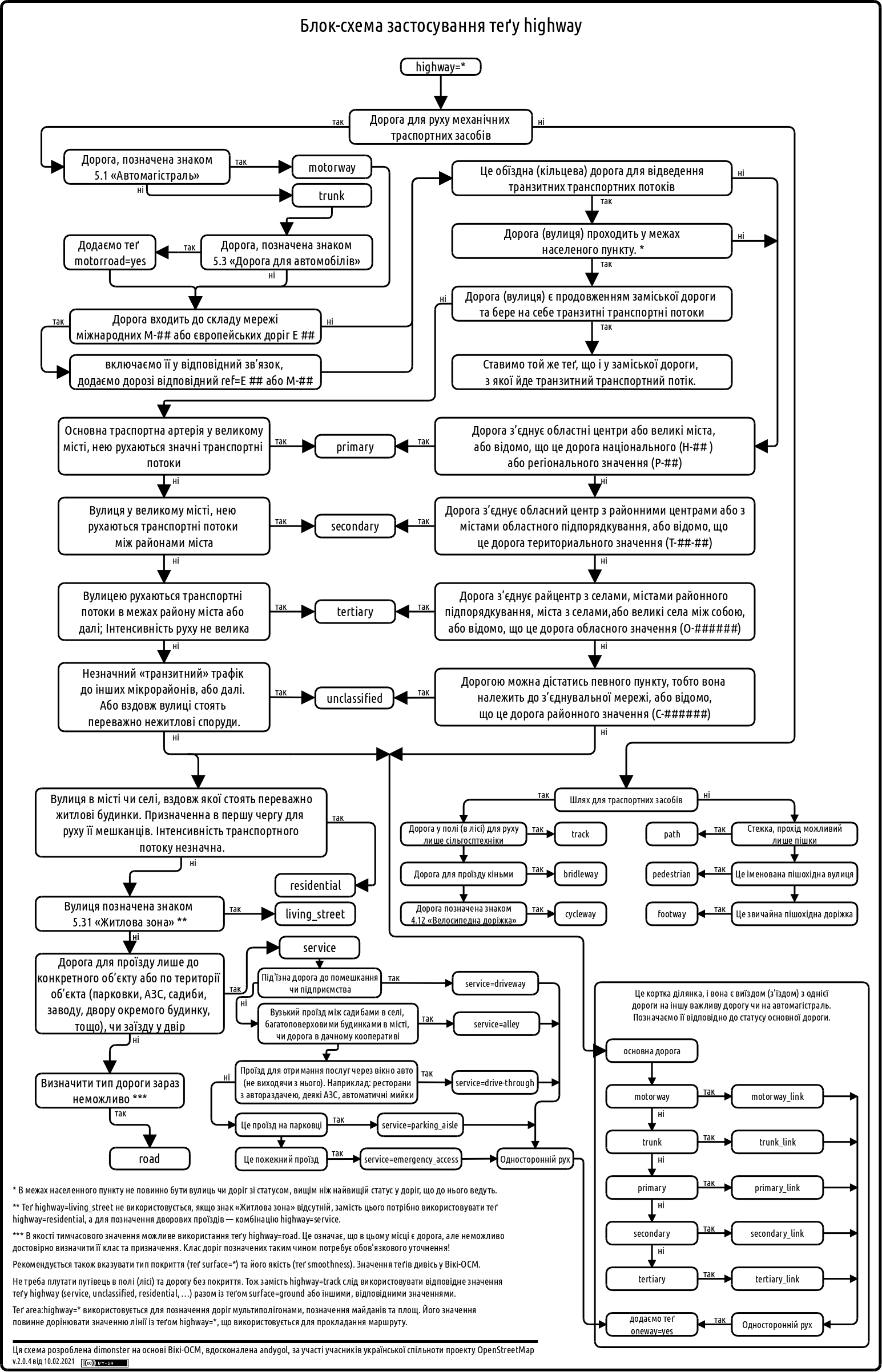
Following a suggestion by @andygol, I decided to refresh the Highway Tag Usage Scheme used by the Ukrainian OSM community. The original work on this scheme began back in 2013 — see the discussion in the Highways of Ukraine topic. I’d like to share the progress made so far and invite the community to contribute further improvements.

Previous version: Previous version

See full entry

Acabei de criar meu perfil e estou animado para começar a contribuir com mapeamentos na região de Sapezal, Mato Grosso BR. Quero ajudar a tornar os mapas ainda mais precisos e úteis para todos — especialmente nas áreas urbanas, estradas e pontos de interesse locais. Estou explorando o editor iD e aprendendo bastante com os recursos disponíveis. Se você tiver dicas ou quiser trocar ideias, estou por aqui! Vamos juntos construir mapas melhores para o mundo!

Location: Sapezal, Região Geográfica Imediata de Tangará da Serra, Região Geográfica Intermediária de Cuiabá, Mato Grosso, Região Centro-Oeste, 78365-000, Brasil

อาคารราชการ เทศบาลนครบุรีรัมย์

Location: Entertainment area, บุรีรัมย์, ตำบลในเมือง, เทศบาลนครบุรีรัมย์, อำเภอเมืองบุรีรัมย์, จังหวัดบุรีรัมย์, 31009, ประเทศไทย
Posted by Dokdo on 29 July 2025 in Korean (한국어).

분리수거함 위에 지붕이 있는 경우는 어떻게 편집해야 하나요? https://ifh.cc/v-bFfdNa 여러 재질에 따른 분리수거함들과 그 위에 지붕이 있습니다. 일단은 저는 분리수거함 유형의 점을 만들고 지붕 크기만큼 지붕을 그렸습니다. (다음 지도는 본인이 직접 찍은 사진안 분리수거함의 위치입니다. 분리수거함과 지붕 옆에도 초록색 대형 일반쓰레기 수거함이 있습니다)

Location: 울산블루마시티2차푸르지오아파트, 43, 북구, 울산광역시, 44264, 대한민국
Posted by Dokdo on 29 July 2025 in Korean (한국어).

F4 map에서는 지붕 모양 hipped-and-gabled가 mansard로 표현됩니다. 왜 그런 건가요? F4 map에서 경복궁 대다수의 지붕 모양이 실제로 OSM에서 태그된 hipped-and-gabled가 아닙니다. 때문에 중국 자금성의 지붕 모양은 hipped-and-gabled가 아니라 지붕의 모양의 조각들을 따로따로 생성한 것 같습니다.

There has been a recent surge of interest in mapping walking infrastructure in Melbourne. This is very exciting because many parts have been lacking for a long time.

I have been adding some things piecemeal over the years. Recently I have made a more concerted effort to get footpath and crossing data into the Map. Several other users have been doing a huge amount to make this happen.

Here I wanted to briefly share a summary of my approach to mapping these footpaths and crossings. As is custom for OSM, this is not prescriptive at all; just a description of how I am approaching this task. It is based on consistency of edits and consistency with existing and new data.

Footpaths

highway=footway
footway=sidewalk

I am also including the surface where known. Most footpaths are built of concrete, especially in older suburbs. The next most common would be asphalt, but there are still some unpaved footpaths - even in built-up areas. I think this is important to include for accessibility and route planning.

surface=concrete

One important aspect here is that I am mapping footpath ways separately to the crossing ways. Which brings us to…

Crossings

highway=crossing
crossing=*
crossing:island=*
crossing:markings=*

Here is an example of a simple T-intersection that shows my general approach to mapping ways for footpaths and crossings separately.

See full entry

Location: East End Theatre District, Melbourne, City of Melbourne, Victoria, 3000, Australia

ENG: osm.org/user/momiji-takinogawa/diary/407163

タスポが使えるたばこ自販機はauthentication:taspo=yesとタグ付けしてみることにしました。運転免許証、マイナンバーカード、パスポートで年齢確認をする自販機はそれぞれauthentication:JP:driving_licence=yes, authentication:JP:individual_number_card=yes, authentication:passport=yesとしてみます。

日本人への通じやすさの点でauthentication:JP:my_number_card=yesとも迷いましたが、どうも次期デザインのカードでは「マイナンバーカード」の愛称を使うのを止めるかもという話もでていますので。

In Japan, when you buy tobaccos from a vending machine, you first have to prove that you are 20+ years old. Since 2008, The Japan Tobacconist Federation has been issuing “taspo” smart cards to adult smokers. You can apply these cards to cigarettes vending machines to activate them. Back in 2008, 97% of the vending machines supported taspo for age verification.

Due to technical limitations, taspo system was announced to be shut down in March, 2026, and some vending machines are now retrofitted with new age verification modules that accept a driver’s license card, “My Number Card” (which is officially called Individual Number Card in English), and/or passports (ref: list of government-recognized age verification modules for cigarettes vending machines).

I started to tag taspo-compatible vending machines with authentication:taspo=yes, and those with the other verification methods with authentication:JP:driving_licence=yes, authentication:JP:individual_number_card=yes, or authentication:passport=yes, respectively.

Posted by LordGarySugar on 28 July 2025 in English.

A collection/showcase of the different buildings and areas that I have mapped in 3D (through much trial and error). Each location has a link to view on OSM where you can see what building parts and tagging I’ve used to represent these buildings. The heights I have tagged on building parts are mainly calculated by working out the ratio of a building’s height and width in a photo (I used paint.net to measure these dimensions in pixels) and applying this to the width that can be measured from aerial imagery.

Rue de la Providence, Charleroi 🇧🇪

Mapped 23rd July 2025 - location on osm.org / location on F4map A heavily graffitied derelict industrial building on brownfield land outside Charleroi

Parry Place, London 🇬🇧

See full entry

Depuis 2019 que je suis sur OSM, mais depuis 2023 que je contribue activement ici.

Je suis actuellement diplôme de Licence Pro Eco-Tourisme & d’un BTSa DATR (Développement & Animation des Territoires Ruraux). A la fois passionné d’Histoire et particulièrement sensible aux questions environnementales, je suis toujours à l’affut des nouvelles solutions open source, comme Panoramax.

Aime le théâtre & les Jeux de Rôles (dont je n’en fais pas assez) et philosopher.