ওপেনস্ট্রিটম্যাপ লোগো ওপেনস্ট্রিটম্যাপ

42429-এর দিনলিপি

সাম্প্রতিক দিনলিপির ভুক্তি

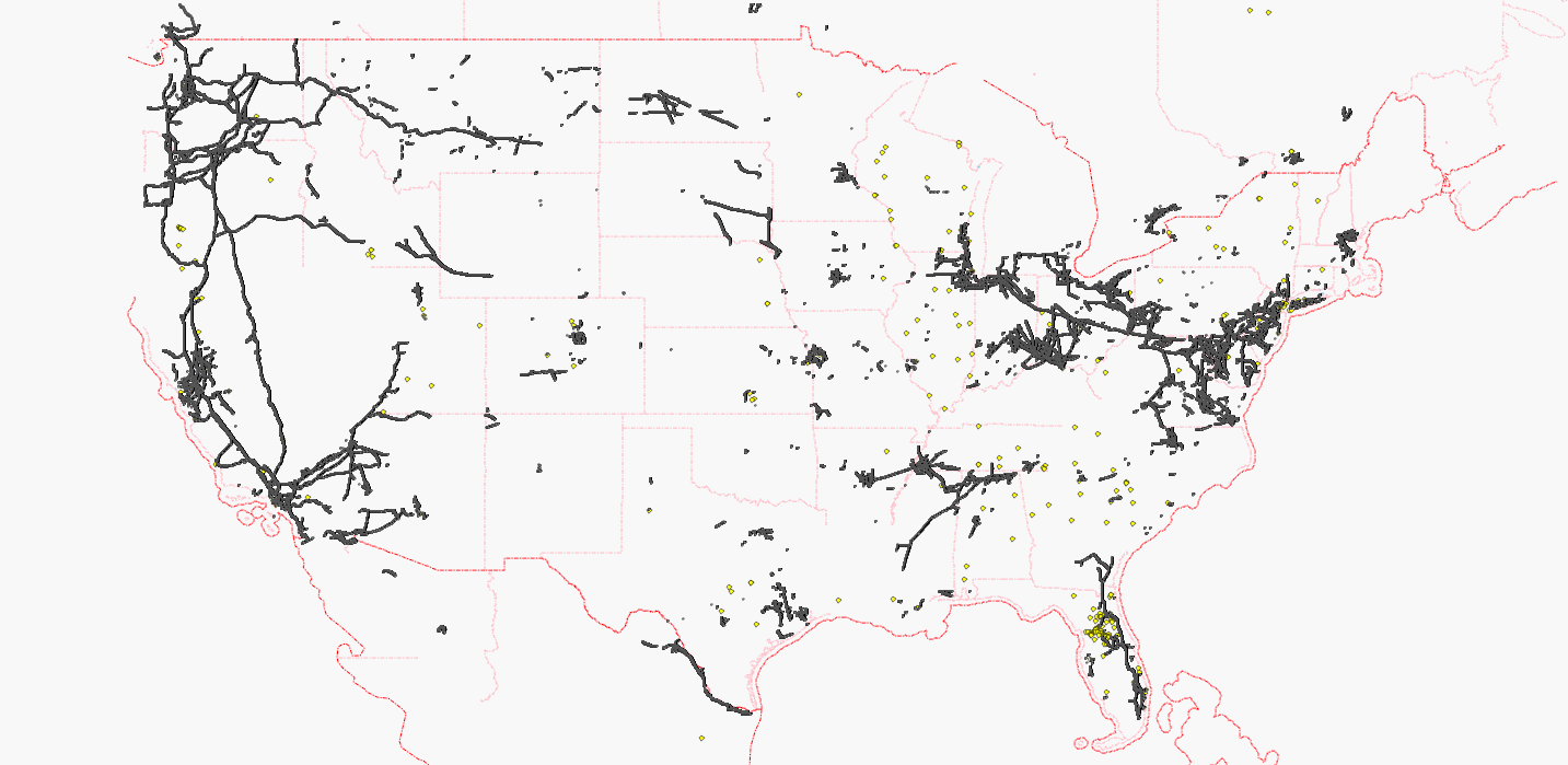
Coast-to-coast powerline is now complete

27 নভেম্বর 2011 তারিখে English ভাষায় 42429 কর্তৃক প্রকাশনা

The coast-to-coast powerline across the United States is now complete. Thanks to the mappers who contributed their part of the transcontinental line (AndrewBuck, asciiphil, bruck4, choess, Chris Bell in California, Gone a.k.a. Nakor, iandees, lyx, mario824, Minh Nguyen, neuhausr, OSchlüter, stucki1, Tronikon, Vid the Kid, Your Village Maps, zephyr)!

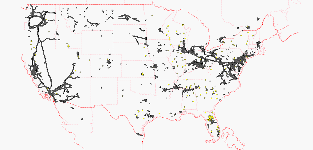
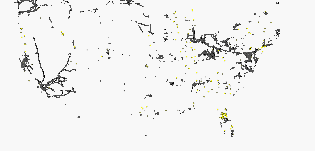
Each black dot represents a pylon, each red dot represents a pole, each yellow dot represents a substation.
White areas are still looking for active mappers, of course. The Gulf Coast is the next destination that needs a coast-to-coast connection.

Maps have been updated on:
osm.wiki/WikiProject_Power_networks/United_States

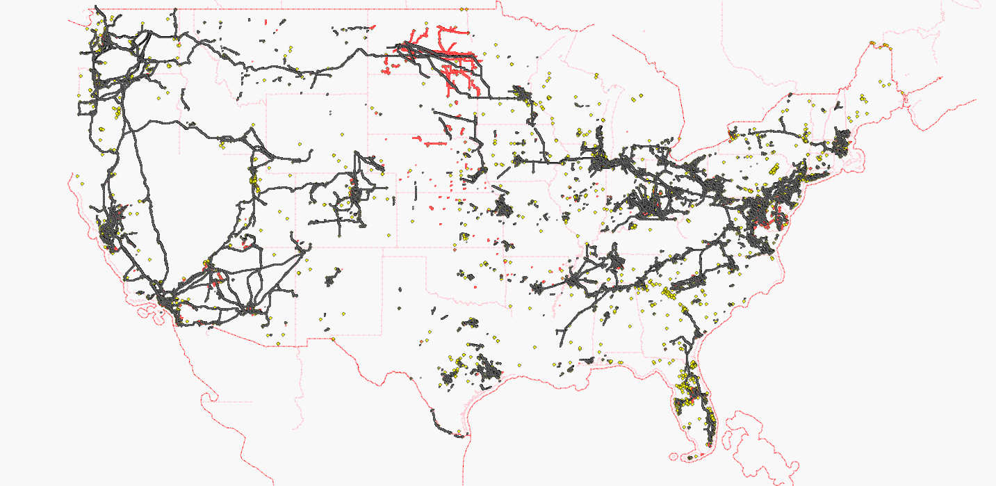
ITO Map shows power lines with voltage tags:
http://www.itoworld.com/product/data/ito_map/main?view=4&lat=39.21897960807571&lon=-96.86002037316652&zoom=5

How to deal with dirt roads?

10 অক্টোবর 2011 তারিখে English ভাষায় 42429 কর্তৃক প্রকাশনা

On the German mailing list one mapper recently asked how to tag a dirt road:
http://lists.openstreetmap.org/pipermail/talk-de/2011-October/089483.html

There are many dirt roads with local importance which should be tagged as tertiary due to their importance, but also as track due to their road condition:

Let's take the Mosquito Pass in Colorado - it is a major connection between Fairplay and Leadville that looks like presented in these videos:
http://www.youtube.com/watch?v=sOOzE2_qrNg
http://www.youtube.com/watch?v=4owzKpG4JPU

I wish we had a tagging mechanism for dirt roads combining importance (highway=*) and road condition (tracktype=* or 4wd=easy/moderate/difficult).

Any suggestions?

অবস্থান: Lake County, Colorado, United States

CT are unacceptable for PD supporters

6 জুন 2011 তারিখে English ভাষায় 42429 কর্তৃক প্রকাশনা

As the elitist mailing list does not allow public answers, I am going to publish my answer here in the blog:

> > The contributor terms say "Subject to Section 3 and 4 below, You hereby
> > grant to OSMF a worldwide, royalty-free, blah blah blah".
> >
> > The one exception might be that OSMF choses the license under which data
> > is published (from the list under "one of the following..."), so
> > everyone else can *only* use the data under that license; whereas OSMF
> > could always use the data under *any* of the named licenses.
> >
> > Oh, and the other exception might be that OSMF can sue others for abuse
> > on your behalf. But again - is that a problem? Would you rather have the
> > sentence about suing for copyright violation removed from the CT, would
> > that be better?
> >
These terms are unacceptable for members who want to distribute their
contributions without any restrictions (public domain). Anybody who wants to
distribute HIS contributions without any restrictions (public domain) should
insist on three different wordings:

"Subject to Section 3 and 4 below, I hereby grant to ANYBODY a worldwide,
royalty-free, blah blah blah".

"only one of the following..." does not fit the personal intention to
distribute personal contributions without any restrictions (public domain)

"OSMF can sue others for abuse on your behalf" should be invalid for those
users who have clicked the Public domain button.

I suppose that roughly 100 contributors have declined because these
Contributor Terms do not enable a valid dedication into Public Domain.

Neubaugebiet in Schwanewede

27 মে 2011 তারিখে German (Deutsch) ভাষায় 42429 কর্তৃক প্রকাশনা

OpenStreetMap ist und bleibt die aktuellste Straßenkarte: Heute habe ich drei neugebaute Straßen in Schwanewede eingetragen, die weder bei Navteq noch bei TeleAtlas vorhanden sind. Auch die staatlichen Vermessungsämter (NiedersachsenViewer) haben diese Straßen noch nicht eingetragen.

These newly built roads are not available at other map providers (Navteq, Niedersachsenviewer, TeleAtlas)

http://tools.geofabrik.de/mc/?mt0=mapnik&mt1=googlemap&lon=8.59166&lat=53.24633&zoom=15

অবস্থান: Vorberg, Welljepott, Schwanewede, Landkreis Osterholz, Niedersachsen, 28790, Deutschland

US power lines are still incomplete

9 মার্চ 2011 তারিখে English ভাষায় 42429 কর্তৃক প্রকাশনা

Each black dot represents a pylon, each yellow dot represents a substation node.
White areas are still looking for active mappers, of course.

Maps have been updated on:
osm.wiki/WikiProject_Power_networks/United_States

The powermap is updated on request:
http://toolserver.org/~osm/styles/?layers=B000F0FF0000F0FFF0000T&zoom=10&lat=41.8083&lon=-83.66106

US power lines are still incomplete

7 ফেব্রুয়ারি 2011 তারিখে English ভাষায় 42429 কর্তৃক প্রকাশনা অন্তিম সম্পাদনা 8 ফেব্রুয়ারি 2011।

Each black dot represents a pylon, each yellow dot represents a substation node.

osm.wiki/WikiProject_Power_networks/United_States

Power outage in the USA

30 ডিসেম্বর 2010 তারিখে English ভাষায় 42429 কর্তৃক প্রকাশনা

Unfortunately, reviewing power lines was not accepted as Project of the Month, so there are still many unreviewed power lines in the USA:

Each black dot represents a pylon, each yellow dot represents a substation.

It would be great if each mapper could add some pylons or substations to the map.

অবস্থান: Rosemary Beach, Lake Charter Township, Berrien County, Michigan, 49106, United States

The world at night

6 ডিসেম্বর 2010 তারিখে English ভাষায় 42429 কর্তৃক প্রকাশনা

the number of illuminated streets is rapidly growing:
http://toolserver.org/~osm/styles/?zoom=2&lat=0&lon=0&layers=B000F0TF0000F0FFFF

Do you want to illuminate your street as well?
Just add lit=yes, if there is light (or lit=no, if there is no light)

Openbusmap shows railroads in the United States

21 আগস্ট 2010 তারিখে English ভাষায় 42429 কর্তৃক প্রকাশনা

After 140 years of continuous service, the railroad between Chicago and San Franscisco is visible on Openbusmap:

http://www.openbusmap.org/?zoom=4&lat=38.32982&lon=-102.78337&layers=BT

Hopefully, Openbusmap will encourage mappers to add new rail and bus lines as relations (type=route, route=bus/rail/subway/tram/trolleybus, ref=99, network=XXX).

Osterholz-Scharmbeck 100% complete

28 ফেব্রুয়ারি 2010 তারিখে German (Deutsch) ভাষায় 42429 কর্তৃক প্রকাশনা

Heute habe ich mich - zum ersten Mal in diesem schneereichen Winter - wieder aufs Fahrrad gesetzt und habe den Bernhard-Minetti-Weg erfasst:

osm.org/user/FK270673/traces/634731

(ausnahmsweise sogar als identifizierbarer Track)

Auf der Karte sieht das Ganze dann so aus:

osm.org/?lat=53.237668&lon=8.800173&zoom=18&layers=B000FTF

Dadurch ist die Stadt Osterholz-Scharmbeck vollständig (100%) erfasst.

অবস্থান: Wiste, Westerbeck, Osterholz-Scharmbeck, Landkreis Osterholz, Niedersachsen, 27711, Deutschland

PGS coastline is dangerous like broken glass

24 জানুয়ারি 2010 তারিখে English ভাষায় 42429 কর্তৃক প্রকাশনা

A small triangle of bad PGS coastline can damage miles of good NHD coastline:
Look at the triangle island in this map before it disappears from the map:

osm.org/?lat=36.202004&lon=-76.45625&zoom=18

If you zoom gradually from 18 to 11 you can see how much damage a little triangle can do.

Anschlussgleis = spur

10 ডিসেম্বর 2009 তারিখে German (Deutsch) ভাষায় 42429 কর্তৃক প্রকাশনা

In ganz Deutschland finde ich Anschlussgleise, die als Hauptbahn (rail) eingetragen sind, obwohl sie eigentlich nur als Anschlussgleis (spur) dienen.

Außerdem sehe ich, dass einige Museumsbahnen nicht als preserved, sondern als normale Bahnlinie (rail) eingetragen sind, obwohl sie höchstens einmal im Jahr befahren werden.

Es wäre schön, wenn jeder in seiner näheren Umgebung diese falschen Einträge korrigieren könnte.

Gruß FK270673

Internet access problems

7 নভেম্বর 2009 তারিখে English ভাষায় 42429 কর্তৃক প্রকাশনা

Today, internet access with German internet provider T-Online is really a problem for me.

I have tried to access the OSM server via IP (128.40.168.98), but the server didn't return even a ping signal.

Do you have similar problems? Is it intended to ignore ping signals?

Yours, FK270673

অবস্থান: Bargten, Buschhausen, Osterholz-Scharmbeck, Landkreis Osterholz, Lower Saxony, 27711, Germany

Worpswede

5 অক্টোবর 2009 তারিখে German (Deutsch) ভাষায় 42429 কর্তৃক প্রকাশনা

Worpswede hat jetzt auch einige Hausnummern (housenumbers).

Dank an Ebbe73 für das Wiederherstellen einer versehentlich gelöschten Kneipe.

অবস্থান: Osterwede, Worpswede, Landkreis Osterholz, Niedersachsen, 27726, Deutschland

Burhave

12 সেপ্টেম্বর 2009 তারিখে German (Deutsch) ভাষায় 42429 কর্তৃক প্রকাশনা

Das Nordseebad Burhave ist mittlerweile auch in der Karte vertreten.

If you don't understand German, just look at the map.

অবস্থান: Klein Fedderwarden, Butjadingen, Landkreis Wesermarsch, Niedersachsen, 26969, Deutschland

Housemapping is a madness

4 আগস্ট 2009 তারিখে English ভাষায় 42429 কর্তৃক প্রকাশনা

In my opinion, mapping housenumbers is simply a madness.

However, I have started to add some housenumbers as well.

অবস্থান: Scharmbeck, Osterholz-Scharmbeck, Landkreis Osterholz, Lower Saxony, 27711, Germany

There is a software bug

1 জুন 2009 তারিখে English ভাষায় 42429 কর্তৃক প্রকাশনা অন্তিম সম্পাদনা 2 জুন 2009।

After having edited my diary, the language setting switches to English though my text remains German.

EDIT: Some hours later, I have added some lines to this entry AND I have tried to change language for THIS entry from English to German - nothing happened.

2nd EDIT: Removed comma between hours and later and changed blog entry language to German - without success.

FK270673