A turn-restriction defines restricted or mandatory turns at a junction and are one of the most important features to map for accurate driving directions. Thought I would quickly make a comparison of how different map data editors visually represent this feature for mappers. Pick the best:

PlaneMad's Diary
Recent diary entries

Usually when meeting old timer GIS users in academia or government, there are a bunch of questions I get asked about how OSM data fits into the more traditional GIS model where data is organised into shapefiles and layers.
Since I could not really find a simple article which explained the difference, spent a few minutes today to come up with a (possibly) easy to understand benefits table for someone in Government. Its not technically accurate, but could quickly help pitch the idea for opening up more data.

Its still very rough, feel free to contribute any suggestions/improvements that could make this useful.
New MapRoulette challenges: Add missing Wikidata ids to cities and capitals
Posted by PlaneMad on 7 April 2017 in English.Just created a couple of mapping challenges for the Wikidata enthusiasts:
- Cities without Wikidata
- Capitals without Wikidata - Europe
- Capitals without Wikidata - Asia and Australia
- Capitals without Wikidata - Americas
There are over 8,000 important places on the map with neither a Wikipedia or Wikidata tag. These challenges are a great way for mappers interested in Wikidata as well as Wikidata contributors to get started with OSM. Do spread the word in your local communities and share your feedback on how to improve the challenge.
While reviewing edits in my neighbourhood, stumbled on a lot of edits by a new editor called StreetComplete. Streetcomplete seems like an open source map editor on Android to quickly add missing metadata to OSM around your location like streetnames, road surface opening hours etc. using a simple form based UI.
 Github: https://github.com/westnordost/StreetComplete
Curious, I listed all the changesets from StreetComplete using osmcha and was surprised to find over 30,000 changesets since the first one in Nov 30 last year. Just yesterday, there was 2,700 changesets uploaded, so there seems to be a sudden surge in editing activity.
The edits in my city were mostly adding the road surface and looked quite good, and its exciting to see such well designed tools driving new contributors to the map. If you are curious use osmcha bbox filter to review edits from StreetComplete in your area and share any observations on the editing activity.
On an average, there are atleast 40 data reverts per day. Most changesets comments are non descriptive like revert previous change making it very hard for the community to track the action and any previous changeset or discussion.
It would be really useful if OSM implemented a changeset mention feature like GitHub, where if I fixed a changeset with a comment Remove duplicate features added in #47398827, it would automatically add a comment to the original changeset and notify the original mapper and anyone in the community know what action was taken. This would greatly improve the social aspect of mapping and link discussions over multiple changesets.
Any other cases where this could be useful?
See the latest changesets by new mappers where:
- maps.me was used to add atleast 10 POIs
- maps.me was used to modify more than 5 POIs
- iD was used to delete more than 50 features
- iD was used to modify over 100 features
- iD was used to add over 500 features
- JOSM was used to delete over 30 features
- JOSM was used to modify over 50 features
- large number of features were deleted, modified and added
- greater than 5 features were deleted, none added or modified
- greater than 20 features were modified. none added or deleted
- greater than 500 features were added. none modified or deleted
Feel free to tweak the filters for any map area or another editor. Do share any other interesting lists.
Protecting the map against Pokemon Go mappers
Posted by PlaneMad on 27 March 2017 in English. Last updated on 28 March 2017.
The Pokemon Go mappers can strike anywhere, converting buildings into parks or pools of water. Check any changeset with ‘Pokemon’ in the changeset comment using osmcha.
A new user deleted over a 100 features including the place node in the centre of Montauban, a large town in France.

Just reverted both these changesets:
Caught and reverted in 15 hours! A few tools where one can review changesets from new users apart from the history tab:

Yesterday, Paris became a bicycle shop named France and today the Zimbabwe capital Harare became Hwinidi offices. This time the edit was from iD. The Mapbox data team caught this while reviewing edits on https://osmcha.mapbox.com/ around 13 hours after the edit.

The Paris city node got renamed to France and tagged with shop=bicycle yesterday. This was found and reverted by user:Chetan_Gowda from the Mapbox data team 27 hours later. For some reason the tiles still show a shop, while the name has got fixed.
While inspecting the Paris node, another user seemed to have renamed the French name to Algerie 6 month ago. This was fixed after 4 hours.
Both edits came through Maps.me, but this is just as simple an edit through any other editor. Its surprising no local mappers noticed this.
Generating a list of all the cities in the world with Wikipedia links
Posted by PlaneMad on 8 March 2017 in English. Last updated on 9 March 2017.A small tutorial on how one can export a CSV of all the cities in the world with their associated Wikipedia and Wikidata pages. This is useful if you want to do some spreadsheet analysis of data from OpenStreetMap.

Overpass Turbo is a great way to quickly extract data from OpenStreetMap by querying tags. An easy way to generate the query is to type “city” or the specific tag “place=city” in the wizard. Since most cities are tagged as just a point node, we can remove the query for ways and relations.
Also instead of the default geojson output, you can use the CSV output format and specify the the data columns to export. The end query looks like this:
[out:csv(::type,::id,name,”name:en”,wikipedia,wikidata)][timeout:200];
( node[“place”=”city”] ({{bbox}}); );
| Try the live query (takes around 2 minutes to run) | View results |
Stumbled upon a dried up Nile on the map, which seems to be a jumble of large multipolygons.

This might require the expertise of an expert with the JOSM relation editor which can be a time consuming process.
Describing Wikidata items with OpenStreetMap tags
Posted by PlaneMad on 23 February 2017 in English.For the curious, the crowdsourced open knowledge database - Wikidata has a property for OpenStreetMap tags that can be used to tag items that describe the same/similar object on the Wikidata database.
It took some time to understand how Wikidata items are described having been used to the more flat OSM tagging model, but we can use a simple example of the popular OSM tag of that is used for any human settlement as a start.
Finding a Wikidata item describing an OSM tag
Any notable topic that exists on Wikipedia will exist as a Wikidata item. Hence any widely used OSM tag should be easy to match to a Wikidata item. For example, cities are one of the most important features of maps, and from the OSM Wiki we know that this feature is described on the map using the Tag:place=city.

If we can find a Wikipedia page that describes the same concept as the OSM tag, we can get the associated Wikidata item from the sidebar links of the page. The Wikidata item for a city is Q515.
Stumbled upon this mistakenly dragged node thats been hanging around Sheffield for the last two months. Considering its not fixed despite having a highly active mapping community, wonder if some tooling could have helped flagged this to local mappers sooner.

Ideas on how to prevent such edits in future? Any existing QA tools that highlight this?
There are a couple of proposed tagging schemas for intense mappers to map street areas and road markings to enable a much more detailed road rendering with accurate widths and lanes.
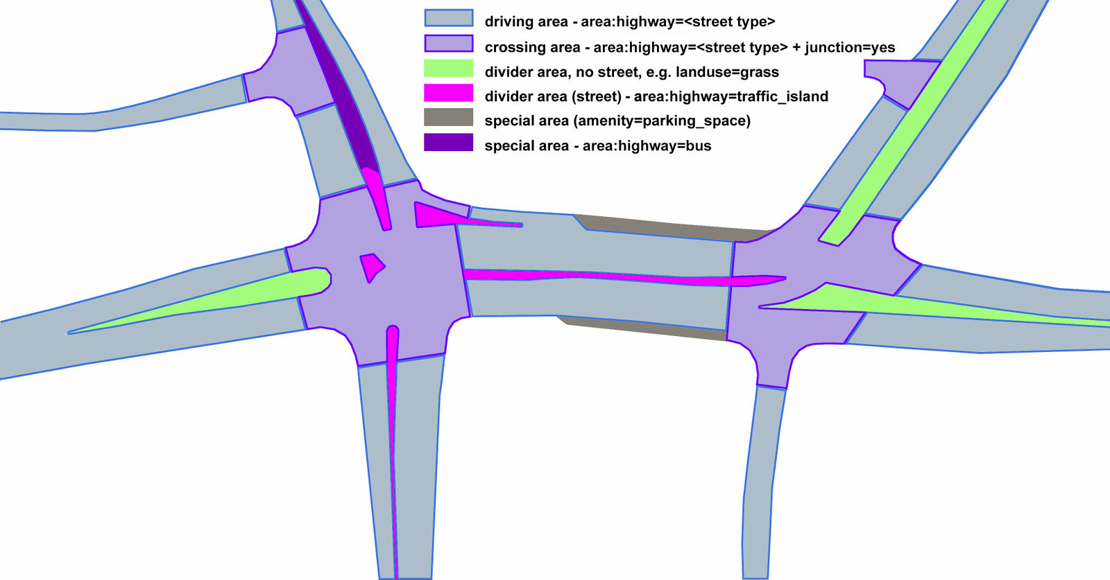 Proposed tagging schema for street areas
Mappers are already active in Poland using this proposal and also have a renderer in place to visualize this with pretty impressive results.
In India, MapMyIndia is one of the biggest aggregators of commercial map data, including running their own fleet of mapping cars, so it was quite interesting to find OSM data in their map for areas i’m familiar with and have mapped on the ground.

Its not all OSM though, will need to dig more into how they mix the data.
Planning a trip to a remote area and realized it would be really cool to meet other mappers in the region where i’m traveling. Wish there was an easy way to broadcast a message to the top/recent contributors in a location. Right now the easiest way seems to be looking at the the list of top users when editing in iD and sending them message.
Any other tools that could help? Very few users are on any community communication channels here in India.
Experiments with an airport style
Posted by PlaneMad on 23 November 2016 in English. Last updated on 27 February 2019.Some late night weekend experiments resulted in this Airport map style.
 Runway and taxiway lights
There are over 40,000 features with old style wikipedia:lang=* tags that need to be migrated to the more popular wikipedia=lang:* format. Should this just be a mechanical edit? Or should we have a worldwide campaign of community members checking each and every one?

Special shoutout to Undearius and LogicalViolinist for their efforts in improving Wikidata coverage in Africa and for bringing a smile to the face of the Sahara.

Some trivia, the Sahara is not all endless sand dunes, one can chance upon some oases and also some potential mappers. Something to lookout for on your next trip there.