aaronsta's Comments
| Changeset | When | Comment |
|---|---|---|
| 104367394 | over 3 years ago | (in the above I am referring to the Welshpool Road and Leach Highway intersection) |
| 104367394 | over 3 years ago | Hi RichieRRR, Please make sure you look at the Wiki and do correct tagging, you incorrectly have tagged these roads. Cheers |
| 66334106 | about 5 years ago | Hi ioanam,
|
| 66772826 | about 5 years ago | Hi inah,
|
| 87902120 | about 5 years ago | Hi deathtrapz,
Cheers, |
| 73697715 | about 5 years ago | Hi eichkay, Thanks for your edit,
Cheers, |
| 87603576 | about 5 years ago | Changeset reverted due to multiple conflicts. Proceeding in two-steps. |
| 86589036 | about 5 years ago | Hi Richie,
More info can be found on the OSM wiki,
|
| 52727397 | about 5 years ago | Hi TheSwavu, Please keep in mind that Main Roads Western Australia has no relevance to road names and should not be used or relied on in any way for road names. GEONMA holds road name information. MANY round-a-bouts do not have official names (and the names provided are not "official" (these are more like internal names used by MRWA)), an exception (as an example) is the Point Lewis Rotary. Going forward please do not use or rely on Main Roads Western Australia information, or replace information which already exists with incorrect info. Also note that this issue has been existing for more than two years. It is important to get it right first time every time. Despite this, thanks for your edit it is always good to have people editing the map!
|
| 81247026 | over 5 years ago | Just to add to this the road name "Darkan-Kojonup Road" applies to multiple roads connecting through to Darkan, including some roads which have since been removed / closed. The reason for the name change is due to a change in road alignment. In certain situations the tag "old_name=*" should be used (but this is not it). "Darkan-Kojonup Road" is made up of the following Roads:
Have a look on the map and you can see the old road alignment, for the newer section of Collie Changerup Road (north of Magini Road) it >never< had the name Darkan-Kojonup Road. |
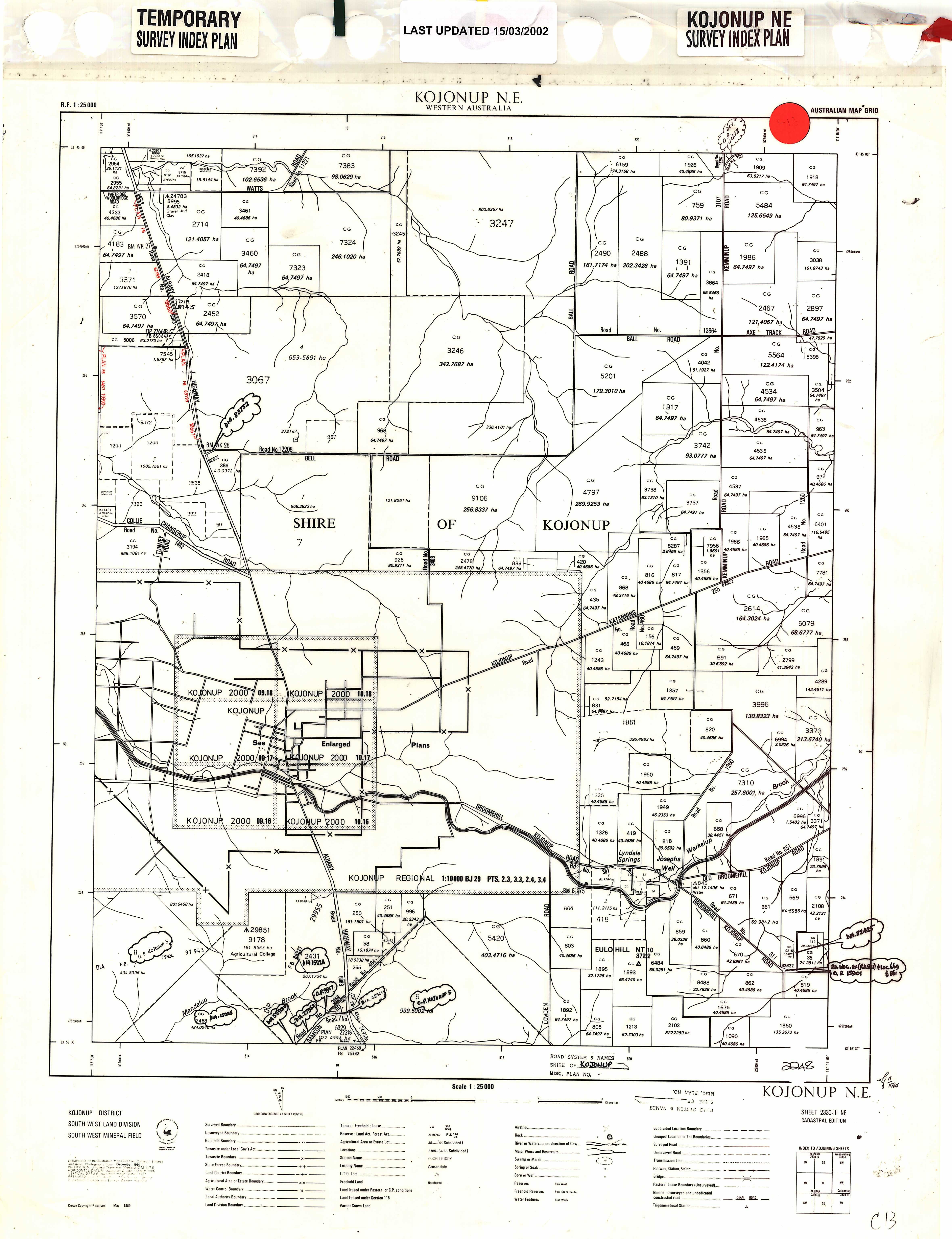
| 81247026 | over 5 years ago | Hi steerage250,
Traditionally these roads did not have names the roads were informally known as the Darkan Road or the Kojonup Road (for the same road) depending on which direction you travelled. When road naming was formalised the two were combined to make "Darkan-Kojonup Road". Subsequently this road was named as "Collie Changerup Road". 'Darkan-Kojonup Road" can be thought of as a placeholder name for when the road is unnamed. See this image:
While there may be signs saying "Darkan-Kojonup Road", this is not the official road name. As it is signed you can add is as "alt_name=Darkan-Kojonup Road" (which I have done). Cheers, |
| 64284139 | over 5 years ago | Hi miroslavuzice87,
|
| 68207207 | almost 6 years ago | Hey shinjiman! Thanks for the message, sorry I've been a bit inactive on OSM for a few months now. I'll update this section of the road sometime soon! (Next couple of days) |
| 71105460 | about 6 years ago | Hi BracknoNe, Regarding,
Cheers for your feedback, and edits.
So a certain level of caution should be used, and if you are not sure it is best to leave it. Regarding the (former) intersection of Charlton Way and Drumpellier Drive.
Also, as a side note that when it was fixed by shinjiman it was classed as highway=cycleway. Shared paths should be classed with the following set of tags: highway=path
As at: osm.wiki/Australian_Tagging_Guidelines#Urban_Footpaths_and_Cycleways I have also attached the latest available aerial images I could source available at:
|
| 68399546 | about 6 years ago | Hi lonadr, Thanks for your edit :) Just a reminder to make yourself familiar with the OSM Wiki before undertaking any edits. There are four primary issues with this edit: 1. For Australian edits, and as per Australian road rules a single white line / (as well as double white line in Australia) is crossable by vehicles for the purposes of entering or leaving the road (such as turning into a driveway or another road). Roads like this should not be divided. As there is not actual division or limitation for traffic to turn (but if you divide the road, then you create one, and potentially make routing problems). If there was a physical kerb then dividing the road would be appropriate. 2. As per Western Australian guidelines the road hierarchy should (generally reflect the Main Road Western Australian road hierarchy. Additionally this is a dead-end / no through road (south of Amelia Street). The correct classification is as a Residential Street (See this link:)
3. Round-a-bouts should not be tagged with any name=* value (unless the round-a-bout itself is named, for example the Point Lewis Rotary near the Narrows Bridge / Kings Park in Perth. As the Perth editing community is small, mistaken edits can take months or years to be identified, if at all for those less obvious ones. As a result it is important to get edits right first time every time. 4. There are no bicycle lanes on this stretch of road. All the best, |
| 66742114 | about 6 years ago | Hi danuta, Thanks for your edit :) Just a reminder to make yourself familiar with the OSM Wiki before undertaking any edits. There are three primary issues with this edit: 1. For Australian edits, and as per Australian road rules a single white line / (as well as double white line in Australia) is crossable by vehicles for the purposes of entering or leaving the road (such as turning into a driveway or another road). Roads like this should not be divided. As there is not actual division or limitation for traffic to turn (but if you divide the road, then you create one, and potentially make routing problems). If there was a physical kerb then dividing the road would be appropriate. 2. As per Western Australian guidelines the road hierarchy should (generally reflect the Main Road Western Australian road hierarchy. Additionally this is a dead-end / no through road (south of Amelia Street). The correct classification is as a Residential Street (See this link:)
3. Round-a-bouts should not be tagged with any name=* value (unless the round-a-bout itself is named, for example the Point Lewis Rotary near the Narrows Bridge / Kings Park in Perth. As the Perth editing community is small, mistaken edits can take months or years to be identified, if at all for those less obvious ones. As a result it is important to get edits right first time every time. All the best, |
| 65061586 | about 6 years ago | Hi magrej,
Just a reminder to make yourself familiar with the OSM Wiki before undertaking any edits. Round-a-bouts should not be tagged with any name=* value (unless the round-a-bout itself is named, for example the Point Lewis Rotary near the Narrows Bridge / Kings Park. As the Perth editing community is small, mistaken edits can take months or years to be identified, if at all for those less obvious ones. As a result it is important to get edits right first time every time. All the best, |
| 69226201 | about 6 years ago | Hi Steerage250, Cheers for your edit,
Also note that in this edit you added a crossing where there is infact no pedestrian crossing at this location. Please ensure that you know that features actually exist either by (preferably) visiting in person. Please do not solely base decisions on outdated, low quality aerial images. As the Perth editing community is small it can take months or years (if at all) for mistaken edits to be picked up. As a result it is critical to get edits correct first time every time. All the best, |
| 65423642 | about 6 years ago | Hi Aleksandar Matejevic, Thanks for your edit :)
Perth has a small editing community and it is >critical< that you do your edits right first time every time as a result. It was only by chance that I picked this up. Some mistaken edits, especially those which are not obvious can take months if not years to identify and correct, if ever. Cheers, |
| 66764392 | about 6 years ago | Hi Olivia,
This is not an isolated issue with telenav updates in Perth with the ability to make turns remove when they are legally and practically still possible. Nonetheless your updates are appreciated. Cheers :) |