zstadler دے کمنٹس
| تبدیلی سیٹ | کڈݨ | رائے |
|---|---|---|
| 164099251 | 6 ݙیہاڑے پہلے | Hello TedIsAwesome, Thank you for your contributions to OSM! The Israeli West Bank barrier cannot be tagged as a boundary because it has an open geometry that cannot be represented as a multipolygon. osm.wiki/w/index.php?title=Relation:boundary&uselang=en says about boundary relations: They are defined in a similar manner as multipolygons: they must contain at least one outer way, and additional ways can be used to define enclaves or exclaves. This changeset was therefore reverted. |
| 21734878 | 8 ݙیہاڑے پہلے | מדובר כאן על מחסום. בניגוד לכל אלמנט אחר במתחם, מתבקש שתהיה לו תגית
בהנחה שאנחנו יכולים להסכים עד כאן, לדעתי מדויק יותר לתייג עם
|
| 21734878 | 8 ݙیہاڑے پہلے | תוכל לצטט או לתת מראה מקום של המשפט/הפסקא/ות שהובילו אותך להבנה הזו? |
| 21734878 | 8 ݙیہاڑے پہلے | תיקנתי |
| 21734878 | 8 ݙیہاڑے پہلے | לאיזה אלמנט אתה מתייחס? |
| 156624223 | 8 ݙیہاڑے پہلے | Hello Sojo13, Thank you for your contributions to OSM! In this edit you have added a "layer=1" tag to osm.org/way/729392502 without adding a bridge tag. Was that done in order to avoid JOSM warnings about crossings between a highway and a stream? |
| 161807035 | 14 ݙیہاڑے پہلے | אם היה, הייתי ממפה אותו |
| 169389321 | 14 ݙیہاڑے پہلے | Hi Gizem, Thank you for responding. In osm.org/changeset/169687330 I have reverted this changeset in order to restore the paths within the public park and removed non-existant paths. Best regards,
|
| 169389321 | 16 ݙیہاڑے پہلے | Hello GizemBaba, I'm planning to revert this changeset in 2 days unless you respond. Best regards,
|
| 169389321 | 19 ݙیہاڑے پہلے | Hello GizemBaba, Thank you for your contribution to OSM and your first contribution in Israel! In this edit you have removed several paths. One and half of the paths connect the park with Ibn Gabirol Street. However, you have also deleted paths in the park, which are not private and are clearly seen in the satellite imagery.
Private paths and driveways that exist on the ground, should be kept on the map. As the wiki explains, roads can be tagged with access=private tag "for example because it is behind a gate, or has posted signage that indicates that the property owner has chosen to disallow access by the general public".
It is somewhat strange that your first edit ever in Israel is based on residents complaints. Could you share these complaints and clarify how these complaints reached you. Thank you for your cooperation,
|
| 169090297 | 21 ݙیہاڑے پہلے | Hello Rawaz, Thank you for your contributions to OSM. In this edit you have modified
Could you fix that? |
| 169140189 | 24 ݙیہاڑے پہلے | סימן שזה היה מזמן :-) |
| 169140189 | 24 ݙیہاڑے پہلے | תודה! |
| 169140189 | 24 ݙیہاڑے پہلے | היי Flayer, האם הבסיס פונה? למשל, עבור השכונה שנראה שאמורה לקום במקומו? |
| 116116014 | تقریباً 2 مہینے پہلے | Thank you for the clarification. Interesting! |
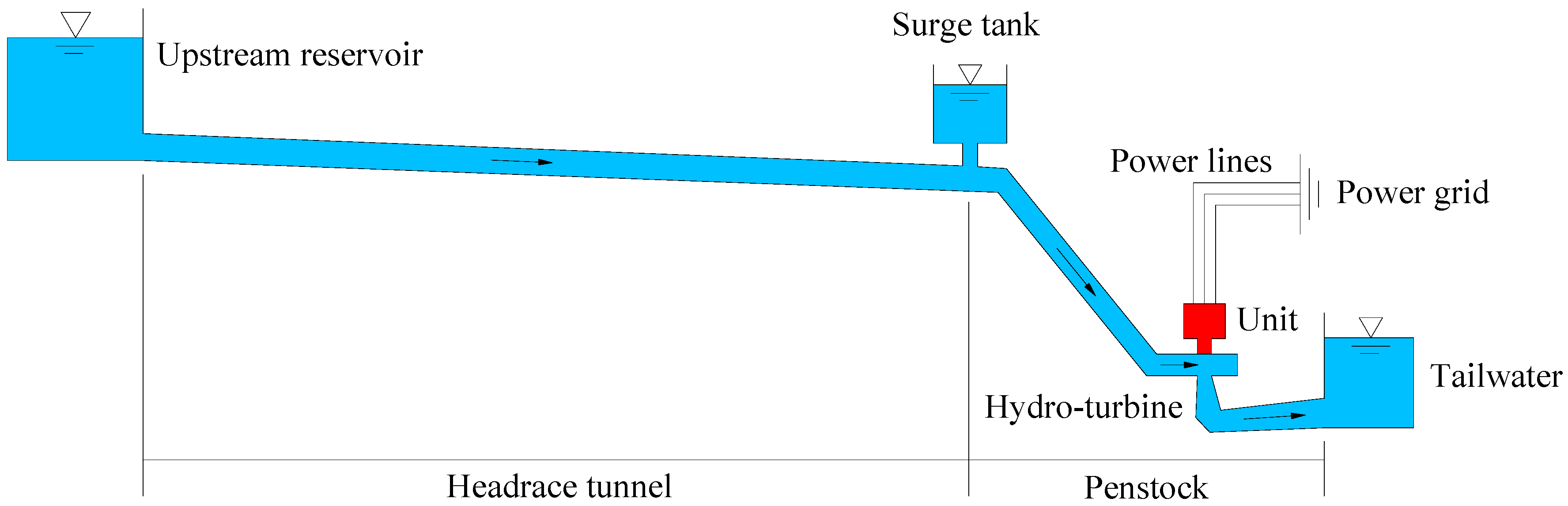
| 116116014 | تقریباً 2 مہینے پہلے | Hello InfosReseaux Thank you for your contributions to OSM. This edit changed the "usage" tag of way 544376704
It was changed from "usage=headrace" to "usage=transmission". If I understand the other tags correctly, this canal is used for hydroelectric power generation, and usage=headrace seems more appropriate. See the "usage" table at
Bonjour InfosReseaux, Merci pour vos contributions à OSM. Cette modification a changé la clé "usage" du chemin 544376704 :
Elle a été modifiée de "usage=headrace" à "usage=transmission". Si je comprends bien les autres clés, ce canal est utilisé pour la production d’hydroélectricité, et "usage=headrace" semble plus approprié. Voir le tableau "Destination" à la page suivante :
|
| 167733416 | تقریباً 2 مہینے پہلے | אפשר, במקביל, לפנות לממפה ולבקש שהוא יפסיק למפות וימחק את מה שכבר מופה.
עכשיו, לצערי, שנים משלושת האתרים שמחקת שוחזרו ואז נמחקו שוב...
|
| 167527182 | تقریباً 2 مہینے پہلے | This changeset was reverted in changeset 167696716 |
| 167668550 | تقریباً 2 مہینے پہلے | This changeset was reverted in changeset 167696739 |
| 167668578 | تقریباً 2 مہینے پہلے | This changeset was reverted in changeset 167696758 |