OpenStreetMap logo OpenStreetMap

Users' Diaries

Recent diary entries

Posted by IsStatenIsland on 2 August 2025 in English. Last updated on 30 August 2025.

Update from August 29th: I’ve upgraded the speeds back to 160. What a crazy exercise of futility. One day later I also obtained summary bulletin order describing most of the changes. There’s still a little more work to do.

Update from August 11th: There are ramblings about the maximum speeds already being changed since July, before I even made this post. I may have shot myself in the foot here although the original editor of the edits I “reverted” presumably didn’t know about the actual rule changes either.

I’ve tried requesting the newest ETT on August 8th and I received the same ETT I already had. The speed changes may have been issued by general order without a general ETT update. As I still have no hard evidence, I can’t yet modify the speed limits yet. It may be necessary to wait for revenue service if nobody can point me to the document I need to request.

On the bright side while going through all of this, I had a chance to closely review speed limits in the Rhode Island and Massachusetts areas. The editors (presumably stevea at least at first) had a solid understanding of the speed change boundaries.

While researching the editor(s), I encountered a changeset that has a URL to yet another ETT I don’t have. Amazing.

https://web.archive.org/web/20121019023013/www.acm.jhu.edu//~sthurmovik/movies/NEC_GO_301_1-18-10.pdf

End updates

https://archive.org/details/AMTK-NEC-employee-timetable-20250505-si

This is the most up to date Northeast Corridor Employee Timetable (ETT) I’ve requested, published May 5, 2025. It contains Amtrak’s maximum authorized speeds on the Northeast Corridor. The Acela 2’s planned speeds (mostly focusing on changing 150 to 160 mph) have not yet been integrated into the rules by Amtrak, despite the observed or assumed compatibility with 160 mph service by track class, catenary structure or demonstration in recent test runs. The current runs remain just that: test runs.

See full entry

Posted by notmyproblem1 on 2 August 2025 in English.

Welcome to my diary, “Where did I macro-mapped” This will be available in English and not Italian cuz: 1. I need to speak better english 2. I will (not now but not far away) wanna macro-mapping in the USA (i heard that they have absolute good imagery!) 3. Wanna move from Italy and go to Wisconsin, USA. — Where did I micro-mapped? I micro-mapped Tre Ponti Est (service plaza/rest area/or whatever you call it) look it in 3d, look it in 2d changeset I also micro-mapped the nearby service plaza/rest area, Tre Ponti OVEST, look it in 3d, look it in 2d, changeset 1, changeset 2 — (If you are looking from when I published. UTC+2 02/08/2025 23:30 or Wisconsin Time 02/08/2025 16:30, The Tre Ponti Ovest is not available cuz of cooldown aka [waiting server](https://en.wiktionary.org/wiki/waiting#:~:text=waiting%20(countable,%2C%20service.)

Location: Faibano di Marigliano, Marigliano, Naples, Campania, 80034, Italy
Posted by rphyrin on 2 August 2025 in English.

“You’ve been involved with OpenStreetMap for at least 15 years,” the interviewers begin, marking the start of the session.

I gasp a little. Wow—15 years? Imagine all the… fights and drama?

So I get a little curious and start tracing this person’s digital footprints across the whole OSM universe. See if I can learn a thing or two.


“Upgraded road 11390 to secondary to make it stand out from all the other roads.. Because it has bus routes and stands out for transit traffic.”

“This reasoning sounds quite arbitrary to me. Also what degree of transit traffic is necessary so that the road has to ‘stand out’? General convention followed elsewhere outside of cities – and as currently documented – is to use this tag of this type and that tag for that type. The way this road stands out is now inconsistent to how other roads of these types stands out. I think it should be restored.”

“Hmm. That is a fun rule that’s easy to implement and validate. But what are you expecting to achieve with it, other than theoretical correctness – which in cartography is useless, as you might have experienced? I made it secondary, because of its heightened importance to transit traffic. So that routing engines prefer it when routing to there and not fall back on local roads. And even visual inspection would send people on it. So what would be the intention on changing it back?”

“The main benefit of mapping it to certain official classification is that this way we have a clear criteria. This official classification after all also generally indicates which roads are actually more important. If we tied tagging values to official traffic density data then probably it’d be considerably more difficult and likely the result wouldn’t be as intuitive for end users. I find that this way it’s rather difficult to decide on which highway value each road should get.”

The conversation abruptly stopped right there.

See full entry

Disclaimer: This is just the start of a diary article, details about mapping objectives, progress and obstacles/questions will follow

Description of the area

The Ndomba Sector (Collectivé de Ndomba) is the easternmost sector of the Kabeya-Kamuanga Territory. While the eastern and southern borders of the sector are as well the borders of the territory (which have already been mapped for years), the western border of the sector is the River Lubi.

Roads and paths

This sector is still very remote, despite of the fact that the big City of Mbuji-Mayi and the highway Route National 1 (RN1) are close by in the south-east and south. The main reason for the remoteness is that a number of meandering rivers hinder or limit the asccess from almost all directions. The main access road from the south and from Mbuji-Mayi has been the one which leaves RN1 at 6° 06 28.3 N / 23° 26 03`` E just west of the village of Tschibombo - only 20 kilometers west of Mbuji-Mayi. This road follows the border of the watersheds of the river Mulenda (east) and of the rivers Lubi and Kagangayi (west). This way the crossing of rivers and streams is avoided for most of the distance.

Location: Ndomba, Kabeya-Kamuanga, Kasaï-Oriental, Democratic Republic of the Congo
Posted by Archit Rathod on 1 August 2025 in English. Last updated on 14 August 2025.

GSoC 2025 Midterm Update: Temporary Road Closures Database and API

Project Overview

I’m excited to share the midterm progress on my Google Summer of Code 2025 project: Temporary Road Closures Database and API for OpenStreetMap. This project aims to create a centralized platform where users can submit and retrieve real-time information about temporary road closures, enabling OSM-based navigation apps to provide better routing around construction, accidents, and other events.

  • Mentor: Simon Poole and Ian Wagner
  • Organization: OpenStreetMap
  • Project Duration: 12 weeks (175 hours)

🎉 Midterm Evaluation Status: PASSED

I’m thrilled to announce that I’ve successfully passed the midterm evaluation! The project is progressing well and is currently on schedule with several components ahead of the original timeline.

Progress Summary

Completed Components (Weeks 1-8)

1. Geospatial Database & Core Infrastructure

  • PostgreSQL + PostGIS setup with Docker containerization
  • SQLAlchemy models for Users and Closures with spatial geometry support
  • Database initialization scripts and sample data loading
  • PostGIS spatial indexing for efficient geospatial queries

2. RESTful API Service (FastAPI)

  • Complete CRUD operations for road closures
  • Spatial query endpoints supporting bounding box and coordinate-based filtering
  • Authentication & Authorization with JWT tokens and OAuth2
  • Input validation and error handling
  • Swagger UI documentation with integrated authentication

3. OpenLR Integration

  • OpenLR encoding/decoding service integrated into the API
  • Location referencing endpoints for map-agnostic road segment encoding
  • Validation endpoints for OpenLR data integrity
  • Closure service enhancement with automatic OpenLR generation

4. DevOps & Infrastructure

  • Docker containerization for easy deployment
  • Environment configuration management
  • AGPL-3.0 licensing for open-source compliance
  • Comprehensive documentation and setup instructions

See full entry

京杭运河镇江段是重要的航运水道,桥梁多为大型公路桥或铁路桥,跨越宽阔的水面。主要桥梁自西向东(大致方向)包括:

高资河桥/高资桥: 位于丹徒区高资街道附近。

润扬大桥(公路桥): 虽然不是直接横跨运河主航道,但其南汊桥(悬索桥)跨越长江,其引桥和接线工程会跨越或邻近运河相关水道(如运粮河等),是区域重要通道。

镇江西高速桥: 沪蓉高速(G42)跨越运河的桥梁。

镇江西互通连接线桥: 连接镇江市区与高速公路的桥梁。

戴家门桥/润兴路大桥: 位于润州区,是市区西部跨越运河的重要通道(S243省道)。

檀山路桥: 连接镇江主城区与丹徒新区的主干道檀山路跨越运河的桥梁。

九华山路桥: 九华山路跨越运河的桥梁。

官塘桥: 位于官塘桥路,是市区南部跨越运河的重要通道。

沪宁城际铁路桥/京沪高铁桥: 高速铁路专用桥梁。

沪宁铁路桥: 京沪铁路(老线)跨越运河的桥梁。

丁卯桥路桥: 丁卯桥路(金港大道市区段)跨越运河的桥梁,是连接镇江主城区与丁卯、大港的重要通道。

谏壁公路桥/越河街桥: 位于谏壁镇,连接越河街,靠近谏壁船闸。

谏壁闸桥: 位于著名的谏壁船闸枢纽处,通常指船闸交通桥或附近跨越节制闸的桥梁,是连接运河两岸的关键节点。非常重要。

雩山桥: 位于丹阳市访仙镇附近(雩山脚下)。

陵口大桥: 位于丹阳市陵口镇,是跨越运河的公路桥。

二、 镇江市区古运河上的主要桥梁 古运河从平政桥(京口闸)进入市区,向东南流经市区,在谏壁汇入大运河主航道。这段河道较窄,桥梁密集且更具历史人文气息。主要桥梁自北向南(入江口到东南方向)包括:

平政桥: 位于古运河入江口(京口闸遗址附近),历史悠久,是古运河的起点标志之一。

新西门桥: 连接新西门内外。

中山桥: 市中心重要桥梁,连接大西路和中山路。

解放桥: 位于解放路上,靠近伯先公园。

虎踞桥: 历史悠久的古桥(现为复建),位于南门大街北端。

南水桥: 位于正东路西端。

珍珠桥: 跨越珍珠路。

塔山桥: 位于塔山路。

丁卯桥: 古桥名,现为区域地名(丁卯片区),该处古运河上有现代桥梁(如丁卯桥路桥跨越的是主运河,非此段古运河)。

谷阳桥: 位于谷阳路上。

丹徒闸桥: 位于古运河汇入谏壁大运河主航道之前的节制闸(丹徒闸)上。

需要注意的关键点 区分主运河与古运河: 京杭大运河镇江段(主航道)宽阔,是国家级航道,桥梁高大、跨度大、数量相对少些(主要是干线公路、铁路桥)。市区古运河是历史河道,穿城而过,河道窄,桥梁密集,多为城市道路桥,更具生活气息和历史感。

数量众多: 以上列出的是主要的、知名的桥梁。实际数量更多,尤其在城市支路和古运河段还会有不少小桥。

名称变化与具体位置: 部分桥梁可能有俗称或历史名称,具体位置描述可能随城市发展略有变化。高速公路桥、铁路桥通常没有特别的名字,常以线路名称指代。

谏壁枢纽: 谏壁船闸和谏壁闸桥是京杭大运河上的关键节点,非常重要。

动态变化: 随着城市建设和交通发展,新的桥梁可能会建设,旧的桥梁可能会改造或更名。

Location: 四牌楼街道, 京口区, 镇江市, 江苏省, 212000, 中国

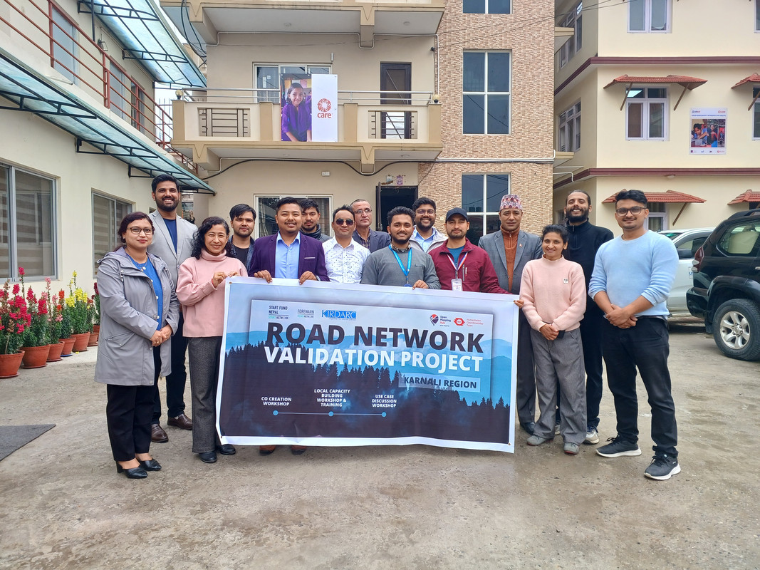
Co-Creation Workshop for Road Network Mapping in Karnali, Nepal

Date: 28 March 2024
Title: Planning & Co-Creation Workshop on Mapping Road Network of Karnali
Venue: Care Nepal, Sanepa
Organizer: Open Mapping Hub Asia Pacific
Led By: Rabi Shrestha, Sr. Field Mapping Expert & Prajwal Sharma, Jr. Field Mapping Expert

Project released for remote mapping

The rugged terrain of Nepal’s Karnali Province tells a story of resilience, isolation, and untapped potential. As the only province where road access remains severely limited—particularly in districts like Jumla—the need for a comprehensive and accurate road network is more urgent than ever. With this in mind, a collaborative Planning and Co-Creation Workshop was conducted to collectively address the challenges, gaps, and opportunities for mapping the road network of Karnali through open-source tools and community engagement.

Setting the Stage: Opening Remarks and Partner Introductions

See full entry

Location: Dhobighat, Lalitpur-04, Lalitpur, Lalitpur Metropolitan City, Lalitpur, Bagamati Province, 40000, Nepal

The Nominatim QA tool added a new layer “Suspicious addr:state value”

  • If addr:state is the same addr:province. Depending on country addr:province might not be needed
  • If addr:state is the same as the country code
  • if addr:state is the same as the country name (in any language)

https://nominatim.org/qa/#map=3.52/34.84/5.81&layer=addr_state_not_country

The layer is updated every day.

Give it a go. But not USA and Canada because I was too eager and made many edits today already.

‘ve found myself drawn to a particular challenge: properly mapping the Rhondda Valleys in South Wales. It’s a task that’s proving both fascinating and frustrating in equal measure, but one that’s teaching me invaluable lessons about the complexities of local geography.

My approach has been quite straightforward - I’ve chosen to focus primarily on Ystrad, the area I know most intimately. This isn’t just because it’s familiar territory, but because understanding one place thoroughly seems like the best foundation for expanding outwards. Every quirk I discover, every mapping technique I develop, and every local peculiarity I uncover in Ystrad becomes a tool I can apply to neighbouring areas.

One of the most surprising aspects of this mapping project has been discovering just how much the “official” maps get wrong. I’ve taken to photographing street name signs and house numbers wherever I go - a habit that’s revealed some genuinely baffling discrepancies between reality and what appears on both Ordnance Survey maps and Google Maps.

The most striking example I’ve encountered is Bryn Terrace in Ystrad. This is a very real street, with real houses, real residents, and real post delivered daily. Yet somehow, it’s completely absent from both OS and Google mapping data. Walking down it, photographing the street sign, and checking my GPS coordinates left me questioning whether I was experiencing some sort of cartographic twilight zone. How does an entire street simply not exist in the digital world when it’s so clearly part of the physical one?

The house numbering systems throughout the Rhondda have provided another source of bewilderment. What might seem like straightforward sequential numbering often reveals itself to be anything but. Streets that appear to follow odd/even patterns suddenly throw in a completely out-of-sequence number, or entire ranges seem to have been skipped altogether.

See full entry

I wanted to share some analysis on a currently undefined part of the PWG Schema (Silver Tier specifically) that I originally posted on the OSM-US Slack. Note that this was discussed previously on the OSM forum, but the analysis here was conducted independently before reading that to.

The key question here: What footway= type, other tags and geometry (separate way from the incoming sidewalk or not) should be specified for the connector ways between the sidewalk centerline and curb nodes?

Currently, the page states only “highway=? + ?=?”; its hard to see how highway= could be anything but highway=footway as nothing else seems more suitable and inventing a new highway type would be a major backward-compat break for little benefit; therefore, the decision then would be what footway=* tag to use.

Survey of options

Surveying the possible options (with pros and cons):

See full entry

Posted by Supaplex on 31 July 2025 in Chinese (Taiwan) (‪中文(台灣)‬). Last updated on 3 August 2025.

原先要在 COSCUP 2025 時講一場,但由於演講場數夠就不佔時段。後來在中研院人社中心的演講有幾頁講 Overture PO 狀況。

信心指數沒有參考性可言。

你會批評 OpenStreetMap 資料的狀況,Overture 也會發生,並沒有神奇藥芳能避免。Overture POI 整體狀況,由於也是群眾編輯機制產生,因此 OpenStreetMap 會發生的問題,Overture POI 也會出現,例如資料過時,新的店家與舊的店家在同一地址都存在 Overture POI 資料集。

個人曾熱衷 Facebook Place Editor,修掉不少不正經的打卡點,如空姐的大腿等。如今 Place Editor 社群散掉了,沒什麼人在修正了。

地址對,圖徵在空照圖像,Overture POI 可能是正確的。不少台北的 POI 點預設點位置常出現在舊莊山區,好像選擇台北的預設位置。

至於對圖客來說,Overture 有用嗎?我覺得如果剛好 Overture POI 是正確的,那就可以複製其資訊過來。

Location: 興雅, 臺北市, 11047, 臺灣
Posted by Hanabano on 30 July 2025 in Persian (فارسی).

زمین درسال ۱۳۶۷به احمدنوریان واگذارشده به صورت خط نوشته درسال ۱۳۹۰ به مجید نوریان اومندنی و۱۴۰۴به امنه باقرزاده کواکی با کد ملی ۰۰۷۷۷۶۶۵۶۳

Location: پرستار, شهر بندر انزلی, بخش مرکزی بندر انزلی, شهرستان بندر انزلی, استان گیلان, ایران
Posted by Anton Khorev on 30 July 2025 in English. Last updated on 4 August 2025.

Some websites allow users to post content with links to other sites and have previews for these links displayed alongside with the posts. Those are typically social media sites, and we’ll refer to them as “social media” in this diary entry. Examples of such sites include: - forums based on Discourse, particularly OpenStreetMap Community Forum - microblogging platforms based on Mastodon, particularly en.osm.town

There are many more of course, with some more widely known examples, such as Facebook and Twitter. We’re primarily interested in the listed above because they are directly related to OpenStreetMap.

A preview usually includes a page title followed by a longer description and an image. Typically when a submitter makes a post with a link, the social media site runs a bot to download the linked web page and scan it for metadata. The metadata usually includes textual attributes and links to preview images. The bot then downloads the images and assembles the final preview to be shown to other users.

Metadata

Here we’re interested in previews of pages on the OpenStreetMap website. Usually the links someone posts are to pages of map locations, editable osm elements (nodes, ways and relations), changesets and diary entries. All of those pages include metadata in one of the formats suitable to generate previews, The Open Graph protocol. The Open Graph metadata consists of several <meta> html elements inside the web page <head>.

The degree to which metadata on OpenStreetMap website pages allows generation of a useful previews however varies. Metadata on diary pages is usually sufficient to build reasonable previews. As an example, we can look at the html source of this diary entry:

See full entry

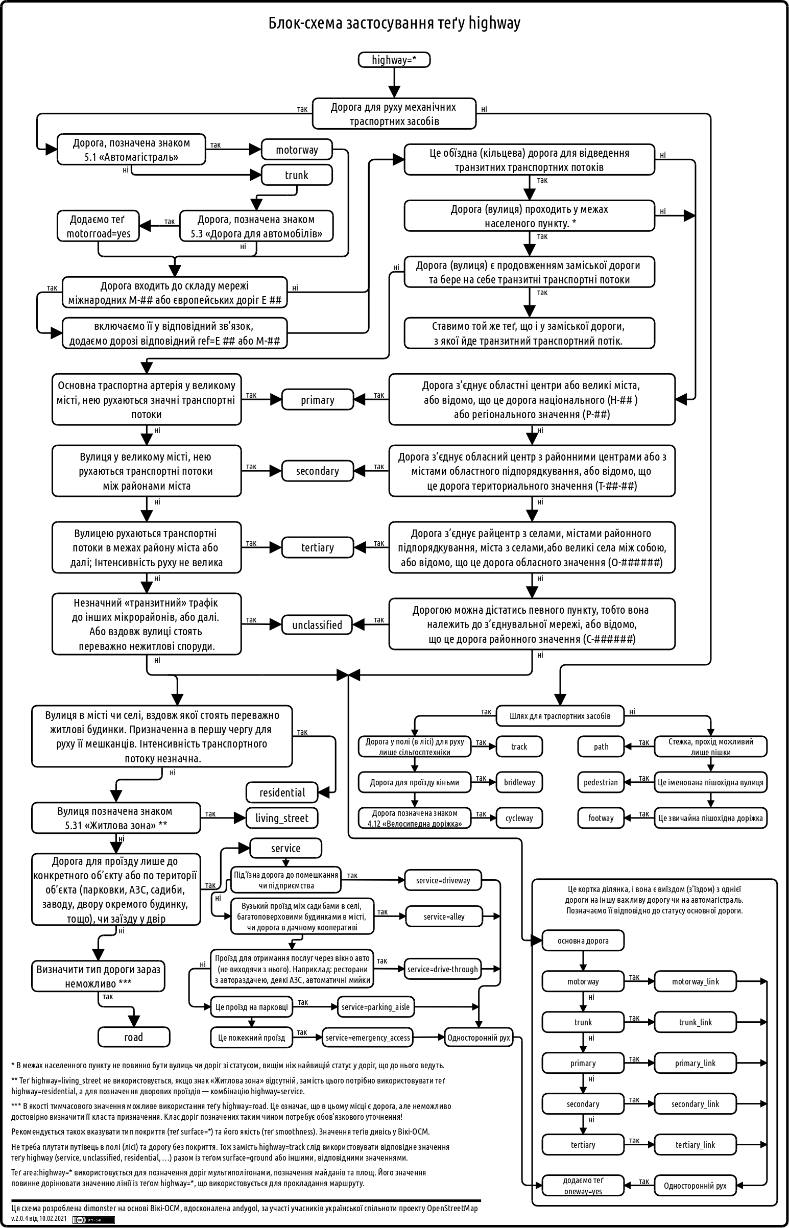
Following a suggestion by @andygol, I decided to refresh the Highway Tag Usage Scheme used by the Ukrainian OSM community. The original work on this scheme began back in 2013 — see the discussion in the Highways of Ukraine topic. I’d like to share the progress made so far and invite the community to contribute further improvements.

Previous version: Previous version

See full entry

Acabei de criar meu perfil e estou animado para começar a contribuir com mapeamentos na região de Sapezal, Mato Grosso BR. Quero ajudar a tornar os mapas ainda mais precisos e úteis para todos — especialmente nas áreas urbanas, estradas e pontos de interesse locais. Estou explorando o editor iD e aprendendo bastante com os recursos disponíveis. Se você tiver dicas ou quiser trocar ideias, estou por aqui! Vamos juntos construir mapas melhores para o mundo!

Location: Bairro Jardim Sapezal, Sapezal, Região Geográfica Imediata de Tangará da Serra, Região Geográfica Intermediária de Cuiabá, Mato Grosso, Região Centro-Oeste, 78366-082, Brasil

อาคารราชการ เทศบาลนครบุรีรัมย์

Location: Entertainment area, บุรีรัมย์, ตำบลในเมือง, เทศบาลนครบุรีรัมย์, อำเภอเมืองบุรีรัมย์, จังหวัดบุรีรัมย์, 31009, ประเทศไทย
Posted by Dokdo on 29 July 2025 in Korean (한국어).

분리수거함 위에 지붕이 있는 경우는 어떻게 편집해야 하나요? https://ifh.cc/v-bFfdNa 여러 재질에 따른 분리수거함들과 그 위에 지붕이 있습니다. 일단은 저는 분리수거함 유형의 점을 만들고 지붕 크기만큼 지붕을 그렸습니다. (다음 지도는 본인이 직접 찍은 사진안 분리수거함의 위치입니다. 분리수거함과 지붕 옆에도 초록색 대형 일반쓰레기 수거함이 있습니다)

Location: 울산블루마시티2차푸르지오아파트, 43, 북구, 울산광역시, 44264, 대한민국