OpenStreetMap logo OpenStreetMap

Users' Diaries

Recent diary entries

Posted by Mannivu on 8 August 2025 in Italian (Italiano).

Ho creato un breve video per spiegare come indicare le corsie, le corsie di svolta e le corsie dedicate al trasporto pubblico locale su OSM. Nel video spiego come farlo usando iD, JOSM e Vespucci (purtroppo non ho accesso all’ambiente iOS, quindi non ho potuto fare alcun video in quell’ambiente). Il video è caricato su Wikimedia Commons, ma sono molto incerto sulla licenza che ho utilizzato, quindi finché è online lo potete trovare in

https://commons.wikimedia.org/wiki/File:Corsie_su_OSM.webm

Se in futuro verrà cancellato, capirò se e come ricaricarlo su un’altra piattaforma.
OBRA COLETIVA SERÁ LANÇADA NO III WORKSHOP MAPEAMENTO PARTICIPATIVO E CARTOGRAFIA SOCIAL - MPCS 2025


Read in English

O livro Estudos de caso em mapeamentos colaborativo e participativo é uma obra coletiva, organizada pela Dra. Raquel Dezidério Souto, que integra 20 capítulos com relatos de pesquisas que adotaram metodologias de mapeamentos coletivos - colaborativo ou participativo e de cartografia social, nas cinco regiões do Brasil e com os mais variados fins, desde a conservação da Natureza, passando pelo reconhecimento das comunidades tradicionais, o inventário da infraestrutura urbana e a valorização do patrimônio histórico-cultural. Esperamos que a sua publicação lance luz sobre a importância e aplicabilidade dessas metodologias e contribua para expandir a rede de conhecimento, em torno dessa temática.

O lançamento do livro já tem data: 29 AGO 2025, 16h (UTC-3), com transmissão pelo canal IVIDES no YouTube

O programa completo do Workshop MPCS 2025 já está publicado nesta direção

Nos veremos em agosto, no evento 100% online e completamente aberto ao público. As inscrições podem ser realizadas na página do evento

See full entry

BOOK RELEASE IN THE III WORKSHOP ON PARTICIPATORY MAPPING AND SOCIAL CARTOGRAPHY - MPCS 2025


Ler em português

The book “Case studies in collaborative and participatory mapping” (original Estudos de caso em mapeamentos colaborativo e participativo) is a collective work, organized by Dr. Raquel Dezidério Souto, which includes 20 chapters with reports on research that adopted collective mapping methodologies - collaborative or participatory and social cartography, in the five regions of Brazil and for a wide variety of purposes, from nature conservation to the recognition of traditional communities, the inventory of urban infrastructure, and the enhancement of historical and cultural heritage. We hope that its publication will shed light on the importance and applicability of these methodologies and contribute to expanding the network of knowledge around this theme.

The book release date has been set: August 29, 2025, at 4 p.m. (UTC-3), with live streaming on the IVIDES YouTube channel

The complete schedule of the Workshop MPCS 2025 is now available here.

See you in August at this 100% online event, which is completely open to the public. The registration is available on the official website

See full entry

Posted by alan_gr on 8 August 2025 in English. Last updated on 17 August 2025.

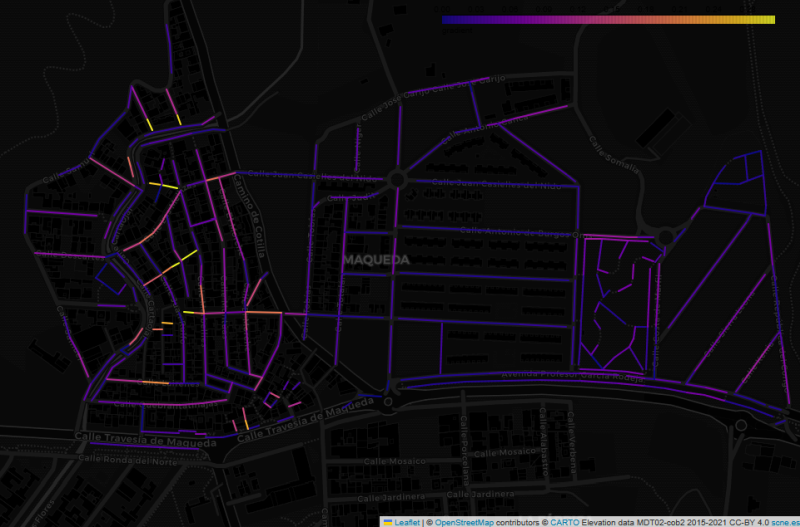
Map of the Maqueda barrio in Malaga, showing streets colour-coded by estimated gradient, on a dark background

This image shows the Maqueda barrio in Malaga, with streets colour-coded by estimated gradient. The flat area to the east shows up with cold colours, while the western part of the barrio, which straddles a ridge, generally has warmer colours. But why did I make this map, and what does it have to do with “streets that are really steps”?

In my wanderings around the city of Malaga, I have often come across flights of steps that are not tagged as highway=steps in OpenStreetMap. Usually they are tagged as residential or footway, with misleading results for anyone using OSM-based maps or routers to find their way around the city.

See full entry

Location: Maqueda, Santa Rosalía-Maqueda, Campanillas, Málaga, Málaga-Costa del Sol, Malaga, Andalusia, 29591, Spain
Posted by shetto on 7 August 2025 in English.

I started mapping on 7 of August using StreetComplete. I discovered (unfortunately) that I understood some criteria concerning road smoothness wrong, and I was no longer sure if my edits from the first day were correct, so I decided to delete most of them, to remap and do it properly. Furthermore, I apologize if anyone had any inconvenience of my poor first mapping steps.

I will stick to mapping and hope to improve in the future. :)

该标签用于提供通往住宅区或住宅区内的道路。虽然这些道路通常允许直通交通,但它们通常不用作直通路线。住宅道路上的大多数交通将用于进出住宅物业。主要通过交通或非住宅交通的道路应酌情使用不同的高速公路标签(例如,)进行标记(参见高速公路)。通往个别住宅的道路通常会被标记为(并且可能)。highway=residentialunclassifiedtertiaryhighway=serviceservice=driveway

对于城镇中的标记,考虑以下因素可能会很有用:

residential– 通常用于定居点内当地交通的街道或道路。主要用于进入住宅物业,但可能包括进入一些非住宅物业(例如街角商店或便利店)。可能会有较低的速度限制或采取交通平静措施。 unclassified– 互连道路网络中优先级最低的道路。当交通不仅用于住宅通道时使用,即使住宅物业也可以通过这条道路进入。 tertiary– 使用取决于当地的地图惯例,但通常用于交通量低至中等的连接或连接道路。可能仍在住宅区,并且可能有住宅物业毗邻,但通常会连接多条住宅道路、当地活动中心或其他郊区。

Location: 世业镇, 镇江市, 江苏省, 中国
Posted by zman809xx on 5 August 2025 in English.

Opener

Woah, I didn’t realize how quickly this would be something I’d like. I know my account has been around since 2022, but I seriously started mapping in mid-2025. ~10k Edits pretty quickly, and turns out I enjoy editing the map. Maybe I’m looking for a job around this kind of work… Who knows.

ALPR’s

Automated License Plate Readers… Man these things are poping up everywhere. I stumbled on Deflock.me recently. I don’t agree with their “Why” but, I don’t agree these things are good for society… I get that we don’t have a “right to privacy” in public spaces, but man…. this seems one flew over the coo koo’s nest. Is pervasive surveillance at this scale really that surprising? My county alone has 95 ALPR’s (mostly by flock) running 24/7/365 rain snow or shine…. That’s 1 camera per 22 sq.mi. or 1 camera per 7700 people.

Its not right…

95 Cameras over 2130 square miles, and estimated 730,000 people.
Posted by Monchinho on 3 August 2025 in Galician (Galego).

Cústame escribir isto pero teño a necesidade de facelo. Vou parar un tempo (non sei se definitivo) porque estou sufrindo unha certa obsesión con OSM, absorbéndome moitísimo tempo e esforzo e creo que comezo a ter algúns problemas psicolóxicos ou de conduta. Ata soño polas noites co mapa. Tamén me decatei que cando alguén cambia as miñas edicións dun xeito errado sufro unha leve ansiedade e ata aquí cheguei. Non quero enfermar.

Un saúdo á comunidade galega e berciana e moita forza.

Location: Las Águilas, Latina, Madrid, Comunidade de Madrid, España
Posted by yrichard on 3 August 2025 in English.

I like technology and adapting it for the sake of technology . I am not addicted to yet we can not escape it. I only carry my phone when necessary , a computer works so much better , a mix of the old and the new ,technology moves very quickly . I’d prefer a GPS to a 5G modem ,API are not as readily available now

Location: New Norfolk, Derwent Valley, Tasmania, 7140, Australia

延吉 222401

图们 222402

敦化 222403

珲春 222404

  • 市域无县道

龙井 222405

和龙 222406

汪清 222424

安图 222426