in welke categorie valt het Wisselbospad in Merelbeke ? Dat bestaat uit horizontale houten planken, licht meanderend tussen achtertuinen en lichte bebossing
Users' Diaries
Recent diary entries

hi

2025年5月24日(土)神奈川県横浜市の上大岡でOpenStreetMapマッピングパーティーを開催しました。上大岡駅東口から南東方面、谷戸地形の調査散策。 Field Papersとmuramotoさん作成の地形3Dプリントを参考にしながら、崖に張り付いた谷戸的住宅街などを確認しました。高い場所へ移動して谷戸の全景をチェック、「黒船来航」で人が集まったとされる丘に移動し、横浜港方面を眺めました。その後、富士見ポイントなどに寄りつつ散策、上大岡駅に戻りました。
Posted by Jiri Podhorecky on 4 June 2025 in Czech (Česky).
Last updated on 18 August 2025.

Když se v pozdním jaru nebo na začátku léta procházíte po loukách v okolí Lipna, Frymburka nebo Českého Krumlova, občas si všimnete neznatelných změn v porostu, rovných linií, kde vegetace roste s jinou intenzitou. Nejde si nevšimnout ani častých betonových skruží uprostřed polí, nebo pastvin.
Jsou to stopy minulosti, kdy se ve velkém prováděly meliorace s cílem odvodnit zamokřené louky a přeměnit je v intenzivně využívanou zemědělskou půdu. Dnes tyto bývalé, ale stále funkční zásahy do vodního režimu krajiny znovu otevírají diskuse. Nejen mezi vědci a ochranáři, ale i mezi zemědělci a krajinnými inženýry.
Dědictví meliorací
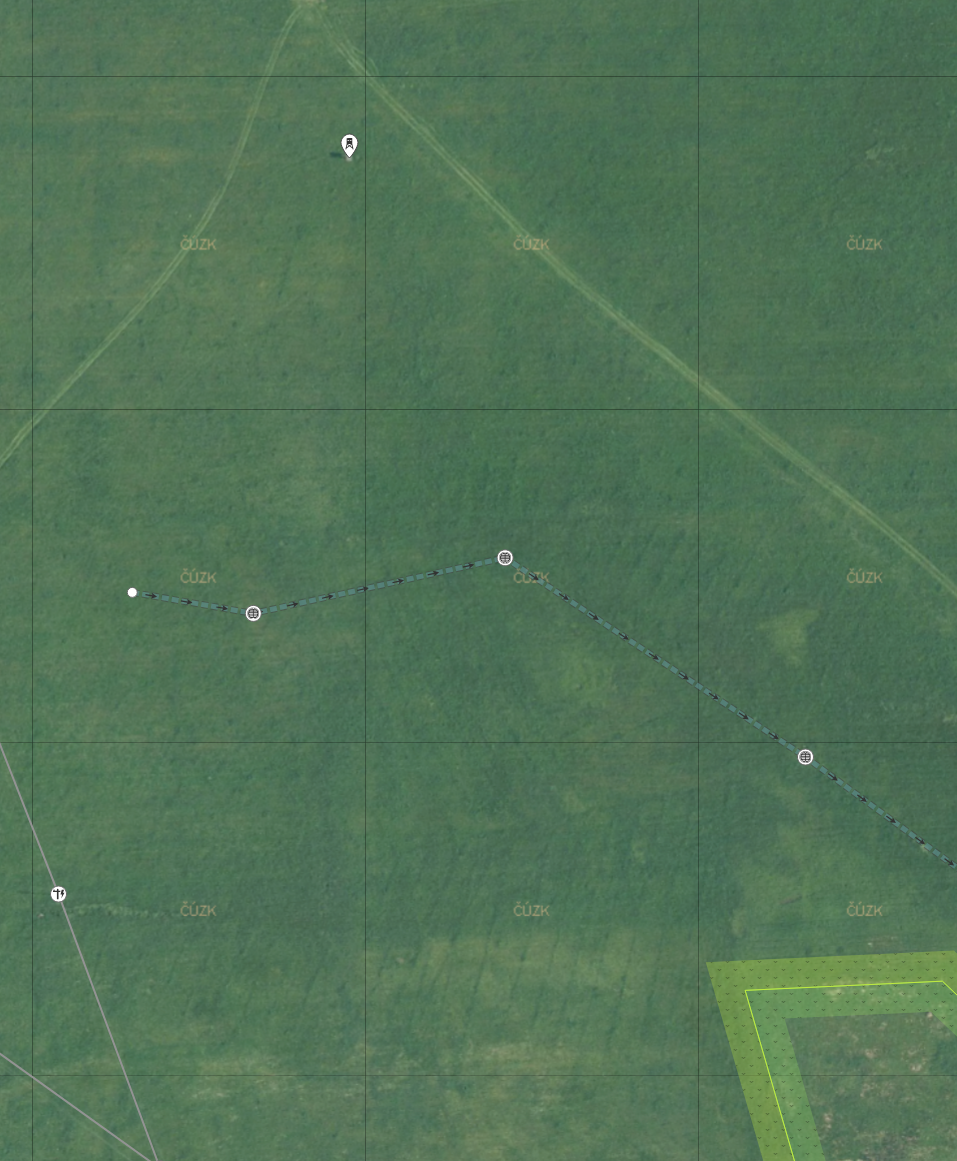
- Na obrázku je výřez louky s patrnými liniemi melioračních brázd u osady Skláře, nedaleko Hořic na Šumavě. Středem louky prochází hlavní odvodňovací kanál, který je osazen skružemi. Ty slouží především jako přístup k čištění. Někdy je z kanálů vyvedena voda na povrch za účelem napáječky dobytka
JOSM + плагины:
Hallo Community,
Ich habe momentan folgendes Problem. Durch unseren Ort ist ein Mapper gegangen und hat 40 von ca. 250 Hydranten gemappt. Diese sind zum Teil fehlerhaft (Falscher Standort, Falsche Typ, kein Hydrant nur Entlüftung, Löschbrunnen als Hydrant deklariert, usw…) von den 40 Stück sind es ca. 10 Stück. Die ganzen Überfluhrhydranten ca. 20 Stück ohne Rohrdurchmesser angegeben. Somit für die Feuerwehr nur bedingt brauchbar. Da der Führungskraft wieder nachsehen muss welche Leitung es ist, um das bereite gestellte Löschwasser zu berechnen.
Ich wollte darauf hin die 40 Hydranten löschen, dies wurde mir leider untersagt. Stattdessen soll ich diese alle Richtig stellen. Dies sehe ich aber nicht als meine Job. Ich kann dies gerne an die Gemeinde weitergeben, diese wollen aber dann einen Lohn für die Arbeiten. Wer übernimmt die Kosten dafür?
Was hilft es uns, wenn nur 40 von ca. 250 Hydranten in dem System sind, wir aber seit 10 Jahren ein anderes System verwenden hier jeden Hydranten mit Bild, GPS Daten, Kennzeichnung ob Einsatzbereit, usw. hinterlegt haben. Diese Jährlich überprüfen und an den Wasserzweckverand Rückmelden mit Schäden.
Die Nachbarwehren nutzen Openfiremap, diese wird mit den OSM Daten gespeist. Sollte nun eine Nachbarwehr zu uns zum Einsatz kommen und sieht in Ihrem System, das ein Hydrant in der Nähe ist, dies aber nicht stimmt?? Weil es nur eine Entlüftung ist oder ein Löschbrunnen.
Wir sind der Meinung das solche Daten von Leuten gemappt werden sollen, die eine Ahnung haben, was Sie machen. Somit die ~Zuständige~ Gemeinde / Stadt / Feuerwehr.
Was ist eure Meinung dazu??
Posted by hermann106 on 3 June 2025 in French (Français).

Apprendre à utiliser JOSM
- Installation JOSM et CREATION d’un Compte sur Openstreetmap
- PRISE EN MAIN DE JOSM ET CARTOGRAPHIE DES BATIMENTS
- Cartographie avec JOSM: l’outil Fusionner les chemins
- Tuto Extrême - JOSM en 3 minutes
- How To Get Started with JOSM
- Cartographie avec JOSM: mode Tracer
- Configuration JOSM
- PRISE EN MAIN DE JOSM ET CARTOGRAPHIE DES BATIMENTS
- JOSM - Voir les adresses en couleurs !
- Autres vidéos
At work1, I started creating a real pedestrian routing that uses sidewalks rather than the middle of the road (unlike most pedestrian routing software nowadays). This is necessary for calculating safe routes to and from schools. In this case, it really matters which side of the road the children use and which crossing they take.
The OSM community mainly uses two methods of mapping sidewalks (and the choice between these two methods directly influences the mapping of crossings): One option is to attach them as tags to the road (for example sidewalk=both), and the other is to use separate geometry. In this post, I would like to show an example where mapping the geometry separately makes a huge difference.
A Dangerous Crossing

The image shows one of Germany’s most dangerous places for pedestrians, according to accident statistics 2. This crossing is located near Rothe Erde in Aachen.
The following figure, taken from a screenshot of JOSM, shows the OSM data for this crossing.3
10 years + a few days ago, we held the White House Mapathon.
Over a hundred mappers gathered and livestreamed the happenings, shared stories of cool mapping projects, dialed in Peace Corps volunteers from the across the globe, and naturally mapped. There were cake pops decorated like globes. Along the walls, stunning reproductions of historic American maps provided by the Archives (I snagged a couple prints, they hang in my office to this day). Everyone dressed formal for the setting, except Alex Barth in usual attire, commenting “Wow OpenStreetMap is fancy today”.
Can you imagine that occurring today? Unimaginable. Of course not.
These kinds of convenings are by their nature fleeting. A recognition and shared touchstone for future work. Yes a bit hype-y, but grounded in real work and real opportunity. This was the era of upswing in open government, open data, the early days of 18F and USDS. The community that gathered there continued championing open mapping in the years after. Some of the most enduring are YouthMappers https://www.youthmappers.org/ and OSM US government initiatives https://openstreetmap.us/our-work/trails/.
We’re now in the age of BS. Truth or not does not matter. That comes from government and AI vibes.
Posted by RuiM on 1 June 2025 in Portuguese (Português).
Como é habitual para mim, encontrei-me perdido em indecisões sobre como começar coisas.
Desta vez foi na sequência de uma conversa de pequeno-almoço em que estive a falar de projetos interessantes que rodem o OpenStreetMap, onde constatei que tenho que arranjar um sitio onde reunir links para mais tarde os encontrar sem ter que andar a fazer scroll em conversas de Telegram, Discord ou Mastodon.
E depois de considerar as muitas opções disponíveis sem encontrar uma ideal, decidi que o melhor é deixar de fazer planos e fazer-me à estrada.
Coisas interessantes que descobri hoje:
- Open Architect Map - Interactive map showing the architects who created buildings and structures, based on OpenStreetMap and Wikidata.
- Open Etymology Map - Interactive map that shows the etymology of names of streets and points of interest based on OpenStreetMap and Wikidata.
En el primer trimestre de 2025 me he dedicado a mejorar el mapeo en la Amazonía colombiana, enfocando resguardos indígenas, caseríos y asentamientos, ríos y, con mayor preocupación, selva deforestada.
got exams will return
Posted by Baloo Uriza on 31 May 2025 in English.

OBDL but governments like Hungary (homophobia), Isreal (genocide), groups like the Republican Party (every stripe of bigotry imaginable) and companies like Tesla (same) are blanket excluded from using, copying, redistributing or accessing OSM data in any way, shape or form?
Posted by user48576 on 31 May 2025 in French (Français).
Last updated on 29 July 2025.
Liste d’attributs occasionnels
Lignes (rues)
- Pour les trottoirs sur lesquels passent des rues : crossing:continuous=yes mais non applicable si la rue est continue et le trottoir séparé (voir traffic_calming=table)
Points (intersections, objets)
- Pour les panneaux d’affichage libre en France : advertising=board et message=opinions;non_profit
- Pour les “rond-points” (carrefours giratoires) franchissable : highway=mini_roundabout
Surfaces (aires, bâtiments)
- Pour les baraques, cabanes et autres bâtiments mixtes stockage et travail ne pouvant être à usage d’habitation : building=shed sauf si building=barn (grange)
- Pour les buissons artificiels n’étant pas des haies : natural=shrubbery avec shrubbery:density=dense (si bloque), medium (si franchissable au besoin) ou sparse (si aéré)
- Pour les “postes EDF” : building=service, power=substation, substation=minor_distribution et utility=power
Propriétés
- Pour ce qui peut être réparé mais est non fonctionnel : disused=yes (voir la documentation)
My name is Saïd Abou Kharroub, and I’m truly honored to be nominated as a candidate for a 2025 HOT voting member. I’m excited to share a bit about my journey with HOT, my current work in Lebanon, and my aspirations as a voting member.
To me, HOT shows the incredible power of people working together with open data in humanitarian crises. It’s amazing how a global community can use mapping to make a real, life-saving difference. What I really appreciate is HOT’s dedication to empowering local communities and building a space where knowledge and skills are freely shared.
My involvement with HOT became very personal and hands-on through the “Lebanon: Conflict - October 2024” project. I got involved when I arrived in Lebanon in January 2025, taking on the role of Lebanon Local Consultant for HOT’s H2H funded project, “Collaborative Approaches to Mapping Damage in Lebanon.” I’ve also been a strategic advisor for CivAPI.com, a data API provider that includes OpenStreetMap layers like buildings, roads, and infrastructure. This advisory role has given me an even deeper understanding of how crucial data provision is in humanitarian and development work.
In my role in Lebanon, I’ve focused on coordinating local data efforts, engaging with important partners, and advising on data protection, especially given the local context. This work includes:
Organizing and hosting local mapathons to grow the OpenStreetMap community and fill important data gaps for humanitarian response. We’ve already held our first mapathons with the Lebanon Reforestation Initiative, Beirut Arab University and are planning the second with the Beirut Urban Lab.
Working closely with HOT staff and humanitarian partners to address specific infrastructure gaps, often responding to requests from groups like UNOSAT.
Posted by SomeoneElse on 31 May 2025 in English.
Last updated on 12 June 2025.
The diameter_crown tag is fairly well used for trees. It’d be nice when showing trees to show larger ones as larger than smaller ones. One challenge is that the values can be a bit hit and miss. There are a couple of sorts of issues there:
One is “obviously silly values from an import gone wrong” like the 289 diameter_crown=width: 2.0; color: green; that have found their way into the database, perhaps by a failed JSON conversion.
Another is “human but not machine readable values” like “4 - 7 m”
Another again is implausible values for certain tree types. For example, this is apparently a London Plane that is 5 times wider than it is high. That’s technically possible with a bit of pruning, but unlikely. Much more likely is that the data was not sanity checked before import, and the “diameter” figure here is actually a “circumference”.
In order to work around these issues, when processing the data prior to display I:
Hi community I’m sharing my application to become a Voting Member of HOT through this diary entry.
What does HOT mean to me?
For me, HOT has been a true school since I started mapping in OpenStreetMap. At the end of 2022, as a founding member of the YouthMappers SAGEMA chapter, we were excited to begin using this tool in our research and community work. My first contact was with Juan Melo, Data Quality Senior Associate at the HOT Open Mapping Hub for Latin America and the Caribbean, who became a mentor to our chapter and taught us the tools we needed to organize our first mapathon at the campus of the Universidad Nacional de Colombia. After that experience, I decided to get more involved in volunteer mapping. That’s how I discovered the Tasking Manager and participated in my first humanitarian project: mapping after the earthquake in Morocco. That experience showed me the real impact of OSM, and how with just a little time, we can help save lives. Since then, I have been part of various HOT projects, and each of them has been a constant learning space. HOT has not only been a platform for action, but also a space for training, connection, and personal and collective growth.
Posted by se_bras on 30 May 2025 in Spanish (Español).
Hola comunidad, comparto a través de esta entrada mi postulación para ser parte del los Miembros de Votación de HOT
¿Qué significa HOT para mí?
Para mí, HOT ha sido una verdadera escuela desde que comencé a mapear en OpenStreetMap. A finales de 2022, como miembro fundador del capítulo YouthMappers SAGEMA, nos entusiasmaba comenzar a usar esta herramienta en nuestros procesos de investigación y trabajo con comunidades. Mi primer acercamiento fue con Juan Melo, Data Quality Senior Associate del Hub de Mapeo Abierto para América Latina y el Caribe de HOT, quien se convirtió en mentor de nuestro capítulo y nos enseñó las herramientas necesarias para realizar nuestra primera mapatón en el campus de la Universidad Nacional de Colombia.
Después de esa experiencia decidí involucrarme en el mapeo voluntario, donde conocí el Tasking Manager y participé en mi primer proyecto humanitario: el mapeo tras el terremoto en Marruecos. Esta experiencia me mostró el impacto real de OSM y cómo, con un poco de tiempo, se pueden salvar vidas. Desde entonces he estado involucrado en diferentes proyectos de HOT y cada uno ha sido un aula constante de aprendizajes. HOT no solo ha sido una plataforma de acción, sino un espacio de formación, conexión y crecimiento personal y colectivo.
Posted by GPSPERU on 29 May 2025 in Spanish (Español).

Sugiero a los desarrolladores del programa openstreetmap que deben adiconar más capas de mapas para editar , tambien tener la opcion de ver el mapa tanto en 3D y 2D, si fuera posible tambien poder girar el mapa 360º y poder ver la perspectiva completa al editar informacion. Gracias.