Users' Diaries
Recent diary entries

Most of our mapping parties, if not all, start with a brief introduction. The newbies are informed about the various benefits of using and contributing to OpenStreetMap, such as massive improvements to the individual’s privacy and an easy mechanism to correct data.
However, I have been wondering if this approach is the optimal path. This doubt started nagging me after I picked up The Theory of the Leisure Class by Thorstein Veblen. If class distinctions are really so pervasive as theorized in the book, shouldn’t we try to incorporate these findings in our promotion of OSM in mapping parties and everywhere else?
A clear description of the context would be in order. Though our existing method of extolling the benefits of OSM is good, I don’t think it is the best one for India. India has, unfortunately, one of the lowest proportion of people contributing to social activities. In conversation with my friends, I often find them considering the idea of “doing something for free” repugnant. Maybe its due to the oppressive nature of the Indian classes, where people’s aspirations are mostly reduced to the singular objective of rising above their current class. Whatever is the reason, we can at least conclude that the current system of promoting OSM is unsatisfactory in the context of India.
We can, for instance, try to frame OSM as a hobby and actively compare the intensity of mapping activity with other mappers (say, by focusing on the heat map that is displayed on the OSM profile page). Setting aside the moral considerations this entails, I believe this approach is likely to bring some interesting results. People may or may not be excited by the idea of increasing their reputation by performing conspicuous leisure in the form of contributions. However, it must be tested on field before we derive any conclusions.
This diary entry was first posted on my website under CC BY-NC-SA 4.0.
Journal de contributeur – Relevés lampadaires à Jassans-Riottier (Avril – Juillet 2025)
Depuis avril 2025, j’ai entrepris un travail de terrain minutieux pour cartographier les lampadaires dans la commune de Jassans-Riottier (01). Mon objectif principal : relever les numéros de référence (ref) visibles sur place et les intégrer dans OpenStreetMap.
Chiffres clés
1 253 lampadaires présents dans OSM sur la zone
794 lampadaires référencés avec un ref visible
459 lampadaires sans ref dans OSM (lampadaires non numérotés ou refs absentes)
Numérotation maximale terrain connue : 1 357 lampadaires
Environ 100 lampadaires à cartographier encore pour atteindre la numérotation maximale
Méthode
Relevés terrain par secteur, avec photos et vérification
Comparaison des données OSM, Overpass, et numérisations communales
Gestion des cas particuliers (lampadaires remplacés, refs effacées, numérotation partielle)
Mises à jour régulières sur OSM
Résultats
Ce travail améliore significativement la qualité des données d’éclairage public sur OSM dans la région, facilitant la maintenance et le suivi des infrastructures. Cela contribue aussi à la précision des cartes et des services dépendants de ces données.
À venir
Finalisation des relevés à Jassans-Riottier prévue pour novembre 2025
Compléter la numérotation sur les lampadaires sans ref
- Complete Notes
- Finish inputting bus routes
- Finish the inside of the MUB
- Colors, heights, and 3D models of the buildings
- Stoke / Paul College area needs love
Who am I ?
I have been retired since 2020 after a long career in networking and IT security.
Since then, I’ve spent my time walking (nothing too ambitious: no mountains, but still around 2,000 km per year) and doing math (a lifelong hobby, mainly algebra focused on functional equations).
I discovered OSM very recently (spring 2025) when switching from Windows to Linux MINT and trying out my first smartphone with LineageOS (a de-Googled Android).
what follows is of course only my personal opinion
At first, I thought it was just a freely editable map application, before realizing that it is in fact:
- a global geospatial database with open contributions, listing and exposing only data that is free of rights, under the most permissive licenses possible.
-
a vast open-source application ecosystem leveraging this geospatial database for a wide variety of uses:
-
to contribute or make smart, efficient, even fun use of it.
- Tools I’ve looked at and used: Id, JOSM, OsmTracker, Osmose, StreetComplete, taginfo, overpass, panoramax, NSI
- Tools I’ve only skimmed so far: MapRoulette, Mon Commerce OSM, Libre Charge Map, H.O.T.
-
to use the database for various purposes aimed at diverse audiences:
- The one that led me to OSM: OsmAnd, then leaflet and uMap
- Also cartes.app, and a bunch of hiking and cycling apps that I’ve only briefly glimpsed.
-
- and of course, a set of proprietary applications built on the OSM database (not always with proper attribution, by the way)
So I created an account, joined OpenStreetMapFrance (not mandatory), and tried to understand enough of the principles, limitations, and recommendations to contribute effectively.
I’m now a regular reader of the WIKI and the forum (even though I sometimes struggle to follow whole conversations – such as those about hiking route relations, linear or networked…).
Espero está sea mi ubicación exacta
peta
For Turkey: (For Ankara, see keyyushi.)
-
Revert/tag correction operations
-
Map verification
Suspicious OSM Changesets It is recommended to change the parameters!
test
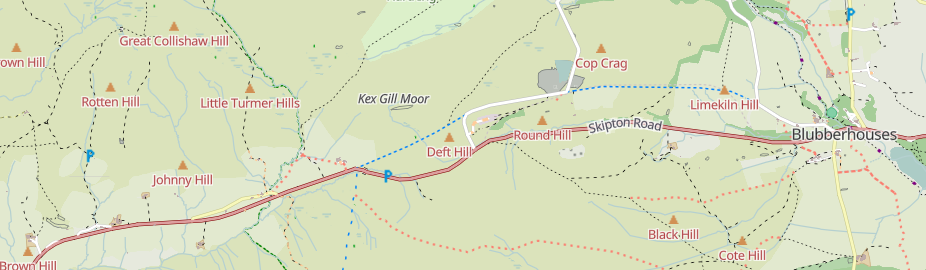
Kex Gill (humorously named the “Côte de Blubberhouses” for a stage of the 2014 Tour de France) is a road in Yorkshire between Harrogate and Skipton. Part of it is gradually sliding down the valley that it is built half-way up the side of and is being rebuilt; it was the access tags on bridleways there that caught my eye in the first place.

The twenty-fourth development diary marks the most significant milestone in OpenStreetMap-NG’s journey to date: the launch of our public test instance. After months of intensive development, we’re finally excited to show it all off! This isn’t just a technical achievement—it’s a pivotal moment in our mission to revolutionize open-source mapping.
🔖 You can read other development diaries here:
https://www.openstreetmap.org/user/NorthCrab/diary/
⭐ This project is open-source — join us today:
https://github.com/openstreetmap-ng/openstreetmap-ng
🛈 This initiative is not affiliated with the OpenStreetMap Foundation.
Public Test Instance Launch 🚀
OpenStreetMap-NG is now live for public testing at osm.ng. This milestone represents months of intensive development, optimization, and preparation to create a stable testing environment for the community. Every mapper, developer, and OpenStreetMap enthusiast can now experience what we’ve been envisioning as the next generation of mapping platforms.
The test environment runs completely independently from the main OpenStreetMap infrastructure. It features the complete OpenStreetMap dataset while providing a safe playground for experimentation and feedback. You can explore all the functionality without worrying about affecting live data—perfect for giving the platform a thorough evaluation.
Liftoff! We have a liftoff, 32 minutes past the hour. Liftoff on Apollo 11.
CloudFerro Infrastructure Partnership

OpenStreetMap went viral! Well, sort of.

A recent Instagram video highlighted an area where Pokémon Go had better trail coverage than Google Maps. You can see for yourself:
Currently, the video has over 12.6 million views and 733 thousand likes!
As you probably know, Pokémon Go uses OSM for its map data. So it’s cool seeing it acknowledged that OSM data performed better, even if it was misguided as a compliment towards Pokémon Go/Niantic.
With a little bit of searching, I found the path that they were on: Way #518694188. Added 8 years ago by BikeRoad.
Hallo,
ich konnte nichts finden und habe auch noch keine gute Idee wie man das hier mappt:
Wer kann helfen?
Netten Gruß bwbuz
-3.423250
OSM有多个含义,但最常见的是指“OpenStreetMap”,即“开放街道地图”。
OSM(开放街道地图)详解: 定义:一个由全球志愿者共同创建和维护的免费开源地图数据库项目。 特性:数据可被任何人自由使用、编辑和共享,这与许多商业地图服务的限制性许可形成鲜明对比。 数据来源:志愿者通过实地测绘、卫星图像分析、公共数据整合等方式贡献。 应用场景:广泛应用于导航、地理信息系统(GIS)分析、研究、商业服务、应急救援、城市规划、交通规划、旅游、学术研究等多个领域。 此外,OSM还提供了丰富的API和各种工具,方便开发者将这些数据集成到各种应用程序中。
Καλησπέρα σε όλους/όλες,
Ως μέλος της ελληνικής κοινότητας του OpenStreetMap, θα ήθελα να σας προσκαλέσω σε συνάντηση της κοινότητας, πρωτίστως διαδικτυακή και μετέπειτα από κοντά, ώστε να γνωριστούμε καλύτερα και να συζητήσουμε διάφορα σχετικά με το OSM.
Για την διαδικτυακή συνάντηση:
🗓️Ημερομηνία και ώρα: Τετάρτη 16 Ιουλίου, 20:00
🔗Σύνδεσμος δωματίου συνάντησης: BigBlueButton
Το BigBlueButton, για όσους δεν ξέρουν, είναι το λογισμικό συναντήσεων που χρησιμοποιεί το OSMF. Για την σύνδεση στο δωμάτιο, αρκεί να βάλετε το όνομα σας, δεν είναι απαραίτητη κάποια εγγραφή.
🗓️🔗Σύνδεσμος συνάντησης στο OpenStreetMap Calendar: https://osmcal.org/event/3894/
Δεν υπάρχει συγκεκριμένη ατζέντα για το τι θα συζητήσουμε, γι’ αυτό γίνεται αυτή η αρχή για κάνουμε μια πρώτη γνωριμία, να δούμε τι θέματα υπάρχουν σαν ελληνική κοινότητα στο OpenStreetMap, και μια γενική συζήτηση για διάφορα περί OSM.
Θα συζητήσουμε επίσης για τα τελικά της δια ζώσης συνάντησης στην Αθήνα, η οποία λογικά θα γίνει Σάββατο 26 Ιουλίου, 3 το μεσημέρι, στο Piu Verde στο Άλσος Παπάγου. Θα βγει νέα δημοσίευση όταν οριστικοποιηθούν οι λεπτομέρειες.
Δείτε την αντίστοιχη δημοσίευση στο φόρουμ, όπου θα δημοσιεύονται οι κύριες πληροφορίες: https://community.openstreetmap.org/t/topic/132512
Για επικοινωνία με τα υπόλοιπα μέλη της ελληνικής κοινότητας, πέραν του φόρουμ, για πιο άμεση επικοινωνία στο τσατ Element.
Σας ευχαριστώ και ελπίζω να ιδωθούμε,
jimkats
Working independently to help plot missing areas but conscious of the current geopolitical situation. Can anyone recommend if there’s any areas to be mapped out of urgency? For instance Texas with the current floods, Gaza or Ukraine etc for the humanitarian issues and destruction of war. I want my work to have as much positive impact and possible and consequentially don’t want to be plotting somewhere remote in say Africa for instance when actually somewhere else is in a much more urgent and desperate need. Many thanks.
مرحبًا بكم في مؤسسة راشد للنظارات، وجهتكم الأولى للبصريات في مدينة الرياض. نقدم لكم مزيجاً من الخبرة والابتكار في عالم العناية البصرية:
- 👓 نظارات طبية وشمسية بأحدث الموديلات
- 🔬 فحص نظر متقدم بأجهزة دقيقة
- 🧑⚕️ استشارات من خبراء مختصين
- 🚗 سهولة الوصول ومواقف مخصصة للعملا
ENGLISH
So, really it’s Gorgona Scalo (or something similiar) to La Spezia Migliarina (cuz of the tunnels, tunnels = no gps = no mapping)
Come with me in the train, (and map anything useful!)
ITALIAN
Quindi, in realtà è da Gorgona Scalo (o qualcosa di simile) a La Spezia Migliarina (a causa delle gallerie, gallerie = no gps = no mapping).
Venite con me in treno, (e mappate tutto ciò che è utile!)
GERMAN
Also, eigentlich geht es von Gorgona Scalo (oder so ähnlich) nach La Spezia Migliarina (wegen der Tunnel, Tunnel = kein GPS = keine Karte)
Komm mit mir in den Zug (und zeichne alles Nützliche ein!)
TRANSLATE IN YOUR LANGUAGE!
by clicking here / this button, you can translate in your language
pss. pss.. deepl translator. not gugglu :)

개인적으로 참고하기 위해 작성한 항목입니다. (수시 업데이트)
도로
- enforcement 관계: 교통법규 단속 장비
- change 키: 차로 변경 가능 여부
- expressway 키: 고속화도로 여부
- motorroad 키: 자동차전용도로 여부